File:Wildfires affect Hawaii.jpg

Original file (4,392 × 2,537 pixels, file size: 2.78 MB, MIME type: image/jpeg)
Captions
Captions
Summary[edit]
| Description |
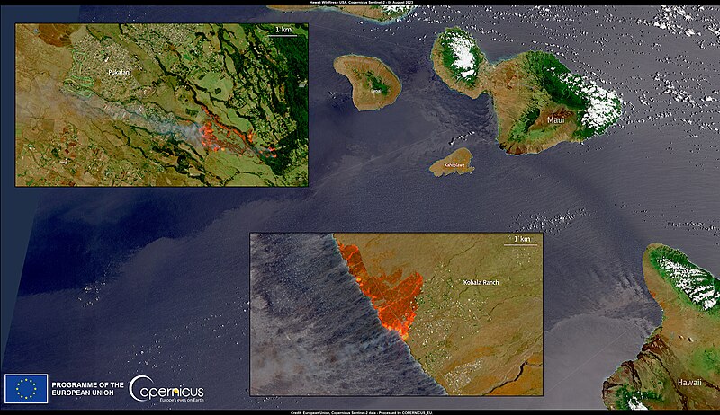
English: Numerous fires are devastating Hawaii. Maui, one of the islands in the archipelago, is the hardest-hit area. Approximately 14,000 homes have lost power, and at least six people have died. Evacuation orders have been issued on the Big Island as a result of the fires which have affected communication and infrastructures. According to NOAA, the flames have been partially fueled by strong winds generated by the passage of Hurricane Dora, located approximately 1,200 km south in the Pacific Ocean. On 8 August, one of the Copernicus Sentinel-2 satellites captured the ongoing fires on Maui and the Big Island. Copernicus plays a pivotal role in facilitating the monitoring and analysis of remote areas. |
| Date | 10 August 2023 (upload date) |
| Source | Wildfires affect Hawaii |
| Author | European Union, Copernicus Sentinel-2 imagery |
Licensing[edit]

|
This image contains data from a satellite in the Copernicus Programme, such as Sentinel-1, Sentinel-2 or Sentinel-3. Attribution is required when using this image.
Attribution: Contains modified Copernicus Sentinel data 2023
The use of Copernicus Sentinel Data is regulated under EU law (Commission Delegated Regulation (EU) No 1159/2013 and Regulation (EU) No 377/2014). Relevant excerpts:
Free access shall be given to GMES dedicated data [...] made available through GMES dissemination platforms [...].
Access to GMES dedicated data [...] shall be given for the purpose of the following use in so far as it is lawful:
GMES dedicated data [...] may be used worldwide without limitations in time.
GMES dedicated data and GMES service information are provided to users without any express or implied warranty, including as regards quality and suitability for any purpose. |
File history
Click on a date/time to view the file as it appeared at that time.
| Date/Time | Thumbnail | Dimensions | User | Comment | |
|---|---|---|---|---|---|
| current | 12:05, 10 August 2023 | | 4,392 × 2,537 (2.78 MB) | OptimusPrimeBot (talk | contribs) | #Spacemedia - Upload of https://www.copernicus.eu/system/files/2023-08/image_day/20230810_HawaiiWildfires.jpg via Commons:Spacemedia |
You cannot overwrite this file.
File usage on Commons
The following page uses this file: