File:Woojin Airport APMS; Terminal 3 Soekarno-Hatta.jpg
From Wikimedia Commons, the free media repository
Jump to navigation
Jump to search
![File:Woojin Airport APMS; Terminal 3 Soekarno-Hatta.jpg](https://upload.wikimedia.org/wikipedia/commons/thumb/8/88/Woojin_Airport_APMS%3B_Terminal_3_Soekarno-Hatta.jpg/800px-Woojin_Airport_APMS%3B_Terminal_3_Soekarno-Hatta.jpg?20170921163851)
Size of this preview: 800 × 532 pixels. Other resolutions: 320 × 213 pixels | 640 × 425 pixels | 1,024 × 680 pixels | 1,280 × 851 pixels | 2,560 × 1,701 pixels | 4,912 × 3,264 pixels.
Original file (4,912 × 3,264 pixels, file size: 8.16 MB, MIME type: image/jpeg)
File information
Structured data
Captions
Captions
Add a one-line explanation of what this file represents
Summary
[edit]DescriptionWoojin Airport APMS; Terminal 3 Soekarno-Hatta.jpg |
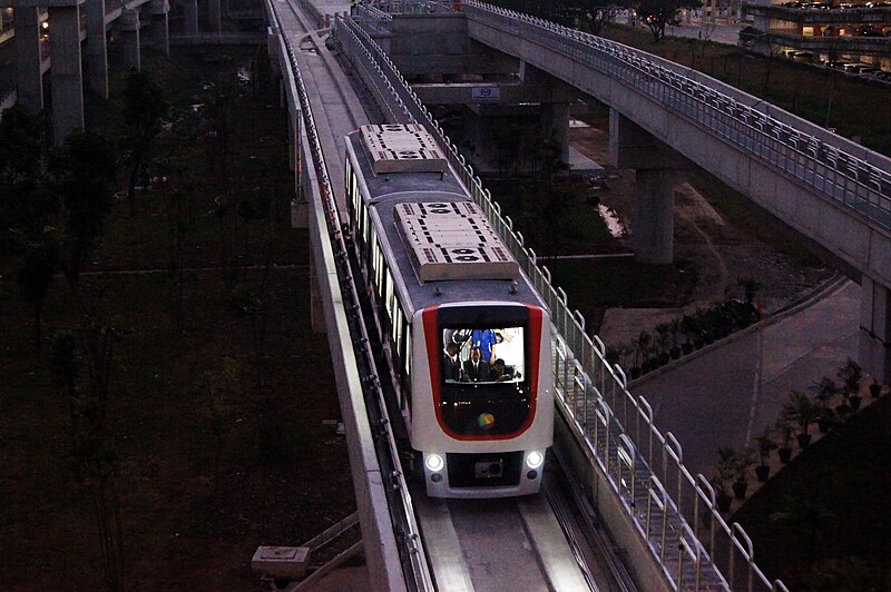
English: The new Woojin-made APMS EMU entering Terminal 3 Station on its third day of service.
Currently the APMS is limited for Terminal 2-Terminal 3, but later it will be extended to Terminal 1 as well as being integrated with Airport Railink station.
Bahasa Indonesia: APMS baru buatan Woojin memasuki Stasiun Terminal 3 pada hari ketiga dinas.
Saat ini APMS masih terbatas untuk Terminal 2-Terminal 3, tapi nanti akan diperpanjang ke Terminal 1 dan diintegrasikan dengan Stasiun Airport Railink |
Date | |
Source | Own work |
Author | Ikko Haidar Farozy |
Camera location | 6° 09′ 05.88″ S, 106° 38′ 11.27″ E ![]() | View this and other nearby images on: OpenStreetMap | ![]() |
---|
Licensing
[edit]I, the copyright holder of this work, hereby publish it under the following license:
![w:en:Creative Commons](https://upload.wikimedia.org/wikipedia/commons/thumb/7/79/CC_some_rights_reserved.svg/90px-CC_some_rights_reserved.svg.png)
![attribution](https://upload.wikimedia.org/wikipedia/commons/thumb/1/11/Cc-by_new_white.svg/24px-Cc-by_new_white.svg.png)
![share alike](https://upload.wikimedia.org/wikipedia/commons/thumb/d/df/Cc-sa_white.svg/24px-Cc-sa_white.svg.png)
This file is licensed under the Creative Commons Attribution-Share Alike 3.0 Unported license.
- You are free:
- to share – to copy, distribute and transmit the work
- to remix – to adapt the work
- Under the following conditions:
- attribution – You must give appropriate credit, provide a link to the license, and indicate if changes were made. You may do so in any reasonable manner, but not in any way that suggests the licensor endorses you or your use.
- share alike – If you remix, transform, or build upon the material, you must distribute your contributions under the same or compatible license as the original.
File history
Click on a date/time to view the file as it appeared at that time.
Date/Time | Thumbnail | Dimensions | User | Comment | |
---|---|---|---|---|---|
current | 16:38, 21 September 2017 | ![]() | 4,912 × 3,264 (8.16 MB) | KujoKaren (talk | contribs) | User created page with UploadWizard |
You cannot overwrite this file.
File usage on Commons
There are no pages that use this file.
File usage on other wikis
The following other wikis use this file:
- Usage on ca.wikipedia.org
- Usage on en.wikivoyage.org
- Usage on fr.wikipedia.org
- Usage on incubator.wikimedia.org
Metadata
This file contains additional information such as Exif metadata which may have been added by the digital camera, scanner, or software program used to create or digitize it. If the file has been modified from its original state, some details such as the timestamp may not fully reflect those of the original file. The timestamp is only as accurate as the clock in the camera, and it may be completely wrong.
Image title |
|
---|---|
Camera manufacturer | SONY |
Camera model | SLT-A55V |
Exposure time | 1/200 sec (0.005) |
F-number | f/5.6 |
ISO speed rating | 6,400 |
Date and time of data generation | 17:59, 21 September 2017 |
Lens focal length | 45 mm |
Latitude | 6° 9′ 5.88″ S |
Longitude | 106° 38′ 11.27″ E |
Altitude | 29.3 meters above sea level |
Width | 4,912 px |
Height | 3,264 px |
Bits per component |
|
Number of components | 3 |
Horizontal resolution | 350 dpi |
Vertical resolution | 350 dpi |
Software used | PhotoScape |
File change date and time | 22:50, 21 September 2017 |
Y and C positioning | Co-sited |
Exposure Program | Shutter priority |
Exif version | 2.3 |
Date and time of digitizing | 17:59, 21 September 2017 |
Meaning of each component |
|
Image compression mode | 3 |
APEX shutter speed | 7.643856 |
APEX aperture | 4.970854 |
APEX brightness | 0.62 |
APEX exposure bias | 0 |
Maximum land aperture | 4.97 APEX (f/5.6) |
Metering mode | Center weighted average |
Light source | Daylight |
Flash | Flash did not fire, compulsory flash suppression |
Supported Flashpix version | 1 |
Color space | sRGB |
File source | Digital still camera |
Scene type | A directly photographed image |
Custom image processing | Normal process |
Exposure mode | Auto exposure |
White balance | Manual white balance |
Focal length in 35 mm film | 67 mm |
Scene capture type | Standard |
Contrast | Normal |
Saturation | Normal |
Sharpness | Normal |
GPS time (atomic clock) | 08:37:43.123 |
Receiver status | Measurement interoperability |
Measurement mode | 3-dimensional measurement |
Speed unit | Kilometers per hour |
Speed of GPS receiver | 1.1 |
Reference for direction of movement | True direction |
Direction of movement | 123.11 |
Geodetic survey data used | WGS-84 |
GPS date | 21 September 2017 |
GPS differential correction | 0 |
GPS tag version | 2.3.0.0 |
Lens used | DT 18-55mm F3.5-5.6 SAM |
Date metadata was last modified | 05:50, 22 September 2017 |
Unique ID of original document | 97CAEC0811A089B7BFF40AD4C80C4718 |