File:World 1898 empires colonies territory.png
Faylın orijinalı (1.560 × 624 piksel, fayl həcmi: 45 KB, MIME növü: image/png)
Captions
Captions
| İzah |
|
||||||||||||||||
| Tarix | 9 iyun 2006 (original upload date) | ||||||||||||||||
| Mənbə | No machine-readable source provided. Own work assumed (based on copyright claims). | ||||||||||||||||
| Müəllif | No machine-readable author provided. Roke~commonswiki assumed (based on copyright claims). | ||||||||||||||||
.jpg)
._LOC_2001620596.jpg)

|
This historical map image could be re-created using vector graphics as an SVG file. This has several advantages; see Commons:Media for cleanup for more information. If an SVG form of this image is available, please upload it and afterwards replace this template with
{{vector version available|new image name}}.
It is recommended to name the SVG file “World 1898 empires colonies territory.svg”—then the template Vector version available (or Vva) does not need the new image name parameter. |
Xülasə[redaktə]
Español[redaktə]
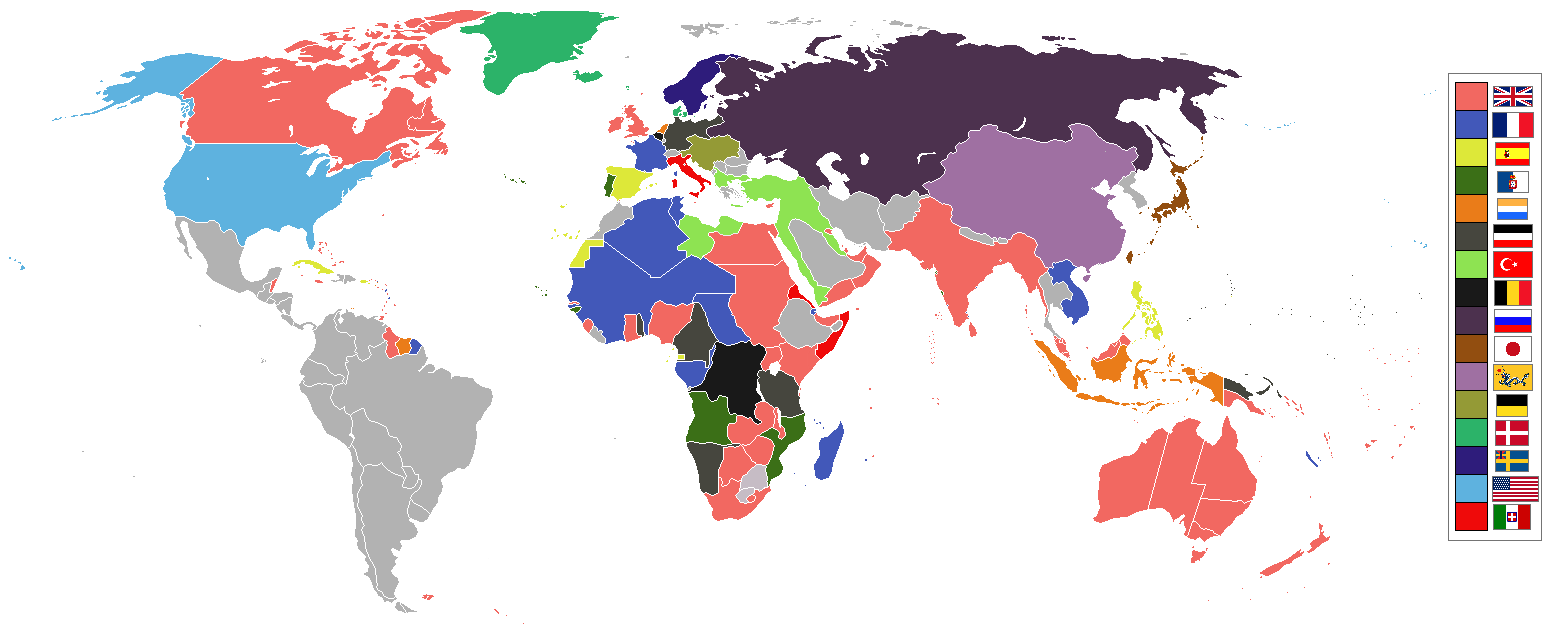
Imperios del mundo y sus colonias, (antes de la Guerra Española-Estadounidense, la Guerra de los Boxer y la Guerra de los Boer, derivado de Image:BlankMap-World-WWI.PNG
English[redaktə]
World empires and colonies 1898, (just before the Spanish–American War, Boxer Rebellion and Boer War), derived from Image:BlankMap-World-WWI.PNG
Tiếng Việt[redaktə]
Français[redaktə]
Empires et colonies du monde 1898, (juste avant la guerre hispano-américaine, la révolte des Boxers et la guerre des Boers, dérivée de Image:BlankMap-World-WWI.PNG).
عربي[redaktə]
مستوحاة من Image:BlankMap-World-WWI.PNG
中文 (繁體)[redaktə]
中文 (简体)[redaktə]
Deutsch[redaktə]
Italiano[redaktə]
Bahasa Indonesia[redaktə]
Imperium dan koloni di dunia pada tahun 1898 (sebelum Perang Spanyol-Amerika, Pemberontakan Boxer dan Perang Boer).
Македонски[redaktə]
Империи и колонии во 1898 г., (веднаш пред Шпанско-американската војна, Боксерското востание и Бурската војна), создадено врз основа на Image:BlankMap-World-WWI.PNG
Nederlands[redaktə]
Wereldrijken en kolonies 1898, (net voor de Spaans-Amerikaanse oorlog, Boxer opstand en Boerenoorlog).
Polski[redaktə]
Imperia i kolonie świata w 1898, (przed wojną amerykańsko-hiszpańską, powstaniem bokserów i wojnami burskimi), na podstawie Image:BlankMap-World-WWI.PNG
Português[redaktə]
Русский[redaktə]
Українська[redaktə]
한국어[redaktə]
1898년 세계의 각 제국과 국가들을 나타낸 지도이다. (미국-스페인 전쟁, 의화단 운동, 보어 전쟁 전의 상황이다.)
日本語[redaktə]
עברית[redaktə]
gurupletos
See also[redaktə]
| Maps of world history | |
| BC | |
|
| |
| AD |
1 · 50 · 100 · 200 · 250 · 300 · 400 · 500 · 700 · 750 · 820 · 900 · 1200 · 1500 · 1556 · 1648 · 1700 · 1750 · 1815 · 1859 · 1871 · 1914 · 1935 · 1954 · 1989 · 2000 · |
|
Maps of colonization history | |
|
see also: Eastern Hemisphere only maps template (1300BC-1500AD) | |
| (this template: · view · discuss ) | |
Lisenziya[redaktə]

|
Bu sənədi GNU Azad Sənədləşdirmə Lisenziyası, Versiya 1.2 və ya Azad Proqram Fondu tərəfindən nəşr olunan hər hansı sonrakı versiya şərtlərinə əsasən dəyişməz bölmələr, ön qapaq mətnləri və arxa qapaq mətnləri olmadan köçürmək, yayımlamaq və / və ya dəyişdirmək üçün icazə verilir; Lisenziyanın bir nüsxəsi GNU Azad Sənədləşdirmə Lisenziyası adlı hissəyə daxil edilmişdir. |
| Bu fayl Creative Commons Attribution-Share Alike 3.0 Unported lisenziyası altında yayımlanır. | ||
| ||
| This licensing tag was added to this file as part of the GFDL licensing update. |
| Annotations | This image is annotated: View the annotations at Commons |
Faylın tarixçəsi
Faylın əvvəlki versiyasını görmək üçün gün/tarix bölməsindəki tarixlərə klikləyin.
| Tarix/Vaxt | Kiçik şəkil | Ölçülər | İstifadəçi | Şərh | |
|---|---|---|---|---|---|
| indiki | 09:16, 8 noyabr 2021 | 1.560 × 624 (45 KB) | Randomastwritter (müzakirə | töhfələr) | jubaland | |
| 07:24, 3 iyul 2019 | 1.560 × 624 (40 KB) | Insider (müzakirə | töhfələr) | the border between East Africa Protectorate and Italian Somaliland per User talk:Insider#File:World 1898 empires colonies territory.png | ||
| 07:18, 31 yanvar 2019 | 1.560 × 624 (40 KB) | Insider (müzakirə | töhfələr) | Arkticheskiy Institut Islands, Izvestiy TSIK Islands, Kirov Islands, Sverdrup Island, Russky Island, Uyedineniya Island, Vize Island and Ushakov Island also is terra nullis at 1898 | ||
| 10:34, 30 yanvar 2019 | 1.560 × 624 (40 KB) | Insider (müzakirə | töhfələr) | In 1898, Grumant, Jan Mayen Island, Severnaya Zemlya, Franz Josef Land, Wrangel island was terra nullius. Fixed Aleutian and Solovki islands. | ||
| 15:56, 6 avqust 2018 | 1.560 × 624 (45 KB) | Lord Obvious (müzakirə | töhfələr) | |||
| 12:04, 12 aprel 2016 | 1.560 × 624 (45 KB) | The- (müzakirə | töhfələr) | Minor fixes | ||
| 21:59, 11 aprel 2016 | 1.560 × 624 (45 KB) | The- (müzakirə | töhfələr) | Minor fixes | ||
| 21:52, 11 aprel 2016 | 1.560 × 624 (44 KB) | The- (müzakirə | töhfələr) | More accurate map | ||
| 02:59, 3 avqust 2014 | 1.554 × 628 (41 KB) | Alvin Lee (müzakirə | töhfələr) | Correcting the boundaries of Russia and China | ||
| 18:36, 23 oktyabr 2012 | 1.554 × 628 (62 KB) | Franco310397 (müzakirə | töhfələr) | Spanish presence in Micronesia (Oceania) included in the Captaincy General of the Philippines. In the Caroline Islands and the Mariana Islands. |
Siz bu faylı yenidən yükləyə bilməzsiniz.
Fayl keçidləri
Aşağıdakı 3 səhifə bu faylı istifadə edir:
Faylın qlobal istifadəsi
Bu fayl aşağıdakı vikilərdə istifadə olunur:
- af.wikipedia.org layihəsində istifadəsi
- als.wikipedia.org layihəsində istifadəsi
- am.wikipedia.org layihəsində istifadəsi
- an.wikipedia.org layihəsində istifadəsi
- ar.wikipedia.org layihəsində istifadəsi
- av.wikipedia.org layihəsində istifadəsi
- az.wikipedia.org layihəsində istifadəsi
- ba.wikipedia.org layihəsində istifadəsi
- bg.wikipedia.org layihəsində istifadəsi
- bn.wikipedia.org layihəsində istifadəsi
- bs.wikipedia.org layihəsində istifadəsi
- ca.wikipedia.org layihəsində istifadəsi
- ceb.wikipedia.org layihəsində istifadəsi
- ce.wikipedia.org layihəsində istifadəsi
- cs.wikipedia.org layihəsində istifadəsi
- da.wikipedia.org layihəsində istifadəsi
- de.wikipedia.org layihəsində istifadəsi
- de.wiktionary.org layihəsində istifadəsi
- el.wikipedia.org layihəsində istifadəsi
- en.wikipedia.org layihəsində istifadəsi
Bu faylın qlobal istifadəsinə baxın.