File:World PVOUT Solar-resource-map GlobalSolarAtlas World-Bank-Esmap-Solargis.png

پروندهٔ اصلی (۱٬۸۸۹ × ۱٬۱۲۲ پیکسل، اندازهٔ پرونده: ۱٫۳۷ مگابایت، نوع MIME پرونده: image/png)
گزینهها
عنوان
خلاصه[ویرایش]
| توضیح |
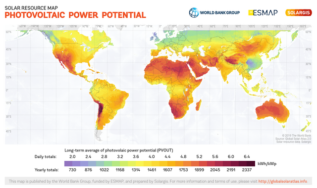
English: This solar resource map provides a summary of the estimated solar energy available for power generation and other energy applications. It represents the average daily/yearly sum of electricity production from a 1 kW-peak grid-connected solar PV power plant covering the period from 1994/1999/2007 (depending on the geographical region) to 2015. The underlying solar resource database is calculated by the Solargis model from atmospheric and satellite data with 15-minute and 30-minute time step respectively, and a spatial resolution of 1 km. Further details available from: https://globalsolaratlas.info. |
||
| تاریخ | |||
| منبع | https://globalsolaratlas.info | ||
| پدیدآور | Solargis | ||
| اجازهنامه (استفادهٔ مجدد از این پرونده) |
https://globalsolaratlas.info/support/terms-of-use
|
||
| انتساب (required by the license) | © The World Bank / | ||

The World Bank and the International Finance Corporation (IFC), collectively the World Bank Group, have published this solar resource map alongside a Global Solar Atlas consisting of global, regional and country maps, to support the scale-up of solar power in our client countries. This work is funded by the Energy Sector Management Assistance Program (ESMAP), a multi-donor trust fund administered by The World Bank and supported by 13 official bilateral donors. It is part of a global ESMAP initiative on Renewable Energy Resource Mapping that covers biomass, small hydro, solar and wind. The World Bank Group has selected Solargis as its global provider of solar resource data and related services, and this map has been prepared by Solargis, under contract to The World Bank, based on a solar resource database that they own and maintain. To obtain additional maps and information, please visit: http://globalsolaratlas.info.
اجازهنامه[ویرایش]
- شما اجازه دارید:
- برای به اشتراک گذاشتن – برای کپی، توزیع و انتقال اثر
- تلفیق کردن – برای انطباق اثر
- تحت شرایط زیر:
- انتساب – شما باید اعتبار مربوطه را به دست آورید، پیوندی به مجوز ارائه دهید و نشان دهید که آیا تغییرات ایجاد شدهاند یا خیر. شما ممکن است این کار را به هر روش منطقی انجام دهید، اما نه به هر شیوهای که پیشنهاد میکند که مجوزدهنده از شما یا استفادهتان حمایت کند.
تاریخچهٔ پرونده
روی تاریخ/زمانها کلیک کنید تا نسخهٔ مربوط به آن هنگام را ببینید.
| تاریخ/زمان | بندانگشتی | ابعاد | کاربر | توضیح | |
|---|---|---|---|---|---|
| کنونی | ۱۵ ژوئیهٔ ۲۰۲۰، ساعت ۱۰:۵۸ | | ۱٬۸۸۹ در ۱٬۱۲۲ (۱٫۳۷ مگابایت) | Juraj.betak (بحث | مشارکتها) | Upgraded data on the map (climate period now to 2018, before to 2015; PVOUT data calculated with updated Solargis model) |
| ۲۵ سپتامبر ۲۰۱۸، ساعت ۱۳:۳۶ |  | ۱٬۸۸۹ در ۱٬۱۲۲ (۱٫۶۸ مگابایت) | O-Jay (بحث | مشارکتها) | User created page with UploadWizard |
شما نمیتوانید این پرونده را رونویسی کنید.
کاربرد پرونده
صفحههای زیر از این تصویر استفاده میکنند:
کاربرد سراسری پرونده
ویکیهای دیگر زیر از این پرونده استفاده میکنند:
- کاربرد در ca.wikipedia.org
- کاربرد در cs.wikipedia.org
- کاربرد در de.wikipedia.org
- کاربرد در en.wikipedia.org
- کاربرد در es.wikipedia.org
- کاربرد در fa.wikipedia.org
- کاربرد در ru.wikipedia.org
- کاربرد در sr.wikipedia.org
- کاربرد در uk.wikipedia.org
- کاربرد در ur.wikipedia.org