File:World Trade Center, NY - 2001-09-11 - Debris Impact Areas.svg
跳至導覽
跳至搜尋

此 SVG 檔案的 PNG 預覽的大小:521 × 599 像素。 其他解析度:209 × 240 像素 | 417 × 480 像素 | 668 × 768 像素 | 891 × 1,024 像素 | 1,781 × 2,048 像素 | 2,110 × 2,426 像素。
原始檔案 (SVG 檔案,表面大小:2,110 × 2,426 像素,檔案大小:203 KB)
說明
說明
添加單行說明來描述出檔案所代表的內容
| 描述 |
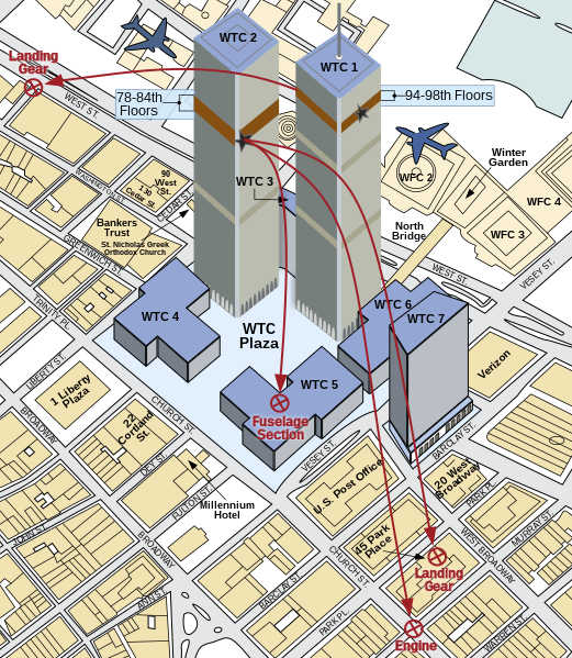
English: A diagram showing the areas where debris from American Airlines Flight 11 and United Airlines Flight 175 fell upon Lower Manhattan during the course of the September 11 terror attacks. |
||
| 日期 | |||
| 來源 | Own work. Derived from 911 - FEMA - Areas debris impact (graphic).png by Therese McAllister, Jonathan Barnett, John Gross, Ronald Hamburger, Jon Magnuson of the Federal Emergency Management Agency (FEMA) of the United States Department of Homeland Security. As a work of the United States government, it was released to the public domain. It can be located on page 6 of this FEMA study. | ||
| 作者 | Cflm001 (留言) | ||
| 授權許可 (重用此檔案) |
我,本作品的著作權持有者,決定用以下授權條款發佈本作品:
此檔案採用創用CC 姓名標示-相同方式分享 3.0 未在地化版本授權條款。
您可以選擇您需要的授權條款。 |
||
| 其他版本 |
本檔案衍生自: 911 - FEMA - Areas debris impact (graphic).png: .png) |
||
| SVG開發 |

檔案歷史
點選日期/時間以檢視該時間的檔案版本。
| 日期/時間 | 縮圖 | 尺寸 | 使用者 | 備註 | |
|---|---|---|---|---|---|
| 目前 | 2022年9月11日 (日) 03:10 | | 2,110 × 2,426(203 KB) | YitzhakNat(留言 | 貢獻) | using inkscapeː fix shadow |
| 2022年9月11日 (日) 02:57 |  | 2,110 × 2,426(198 KB) | YitzhakNat(留言 | 貢獻) | using inkscapeː minor fixes | |
| 2022年9月11日 (日) 01:09 |  | 2,110 × 2,426(196 KB) | YitzhakNat(留言 | 貢獻) | add building shadow, remove text stroke (it doesn't work on wikimedia/wikipedia) | |
| 2022年9月11日 (日) 00:59 |  | 2,110 × 2,426(195 KB) | YitzhakNat(留言 | 貢獻) | compatible font | |
| 2021年8月23日 (一) 02:02 |  | 552 × 630(92 KB) | Praça de Maio(留言 | 貢獻) | File uploaded using svgtranslate tool (https://svgtranslate.toolforge.org/). Added translation for tr. | |
| 2011年10月28日 (五) 22:58 |  | 552 × 630(78 KB) | Fred the Oyster(留言 | 貢獻) | Reduce nominal size, optimise code. | |
| 2011年7月27日 (三) 16:21 |  | 2,110 × 2,426(180 KB) | Wereon(留言 | 貢獻) | sp | |
| 2009年9月30日 (三) 07:55 |  | 2,110 × 2,426(180 KB) | Cflm001(留言 | 貢獻) | {{Information |Description={{en|1=A diagram showing the areas where debris from American Airlines Flight 11 and United Airlines Flight 175 fell upon [[w:en:Lower Manhattan|Lower Manh |
無法覆蓋此檔案。
檔案用途
下列2個頁面有用到此檔案:
全域檔案使用狀況
以下其他 wiki 使用了這個檔案:
- ast.wikipedia.org 的使用狀況
- az.wikipedia.org 的使用狀況
- cs.wikipedia.org 的使用狀況
- cy.wikipedia.org 的使用狀況
- da.wikipedia.org 的使用狀況
- de.wikipedia.org 的使用狀況
- el.wikipedia.org 的使用狀況
- en.wikipedia.org 的使用狀況
- en.wikiquote.org 的使用狀況
- es.wikipedia.org 的使用狀況
- fa.wikipedia.org 的使用狀況
- fi.wikipedia.org 的使用狀況
- fr.wikipedia.org 的使用狀況
- ga.wikipedia.org 的使用狀況
- he.wikipedia.org 的使用狀況
- hu.wikipedia.org 的使用狀況
- ja.wikipedia.org 的使用狀況
- ko.wikipedia.org 的使用狀況
- nds.wikipedia.org 的使用狀況
- nl.wikipedia.org 的使用狀況
- pdc.wikipedia.org 的使用狀況
- pl.wikipedia.org 的使用狀況
- pt.wikipedia.org 的使用狀況
- ru.wikipedia.org 的使用狀況
- sk.wikipedia.org 的使用狀況
- sr.wikipedia.org 的使用狀況
- sv.wikipedia.org 的使用狀況
- vi.wikipedia.org 的使用狀況
- zh.wikipedia.org 的使用狀況
檢視此檔案的更多全域使用狀況。