File:World War I alliances.png
Jump to navigation
Jump to search

Size of this preview: 800 × 396 pixels. Other resolutions: 320 × 159 pixels | 640 × 317 pixels | 1,024 × 507 pixels | 1,280 × 634 pixels | 2,560 × 1,268 pixels | 7,752 × 3,840 pixels.
Original file (7,752 × 3,840 pixels, file size: 1.25 MB, MIME type: image/png)
Captions
Captions
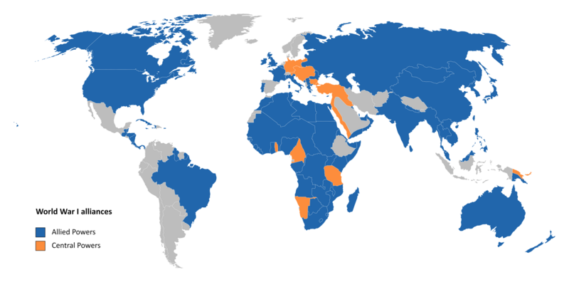
World map of the alliances in World War I
Summary[edit]
| Description |
English: Map of the world in 1914, colour-coded by alliances. The Allied Powers are blue, the Central Powers are orange, and neutral countries are grey.
Legend: Allied Powers
Central Powers
Neutral countries |
| Date | |
| Source | https://historicalmapchart.net/world-1914.html |
| Author | Template created by MapChart; edited by myself |
Licensing[edit]
This file is licensed under the Creative Commons Attribution-Share Alike 4.0 International license.
- You are free:
- to share – to copy, distribute and transmit the work
- to remix – to adapt the work
- Under the following conditions:
- attribution – You must give appropriate credit, provide a link to the license, and indicate if changes were made. You may do so in any reasonable manner, but not in any way that suggests the licensor endorses you or your use.
- share alike – If you remix, transform, or build upon the material, you must distribute your contributions under the same or compatible license as the original.
File history
Click on a date/time to view the file as it appeared at that time.
| Date/Time | Thumbnail | Dimensions | User | Comment | |
|---|---|---|---|---|---|
| current | 00:10, 28 August 2023 | | 7,752 × 3,840 (1.25 MB) | XTheBedrockX (talk | contribs) | Uploaded a work by Template created by MapChart; edited by myself from https://historicalmapchart.net/world-1914.html with UploadWizard |
You cannot overwrite this file.
File usage
The following page uses this file:
Global file usage
The following other wikis use this file:
- Usage on en.wikipedia.org
- Usage on fa.wikipedia.org
- Usage on fi.wikipedia.org
- Usage on fr.wikipedia.org
- Usage on hr.wikipedia.org
- Usage on mg.wikipedia.org
- Usage on sq.wikipedia.org
- Usage on th.wikipedia.org
- Usage on tr.wikipedia.org