File:World airline routes.png
Jump to navigation
Jump to search

Size of this preview: 800 × 370 pixels. Other resolutions: 320 × 148 pixels | 640 × 296 pixels | 1,024 × 474 pixels | 1,280 × 592 pixels | 4,000 × 1,850 pixels.
Original file (4,000 × 1,850 pixels, file size: 2.75 MB, MIME type: image/png)
Captions
Captions
Add a one-line explanation of what this file represents
Summary
[edit]
| Description |
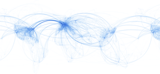
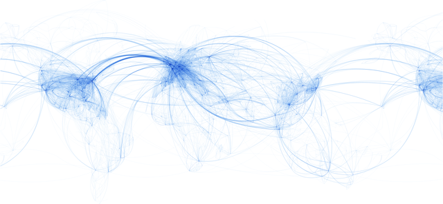
English: Map of global passenger air routes. This image is generally correct, but not specifically correct. Flights take various routes, and the traffic density portrayed is based on the number of airlines on a particular route, not the number of actual flights. Data from Google Maps, Airlineroutemaps.com, and individual airline websites.
Français : Carte mondiale des itinéraires des passagers transportés par les transports aériens. Cette est correcte pour les points de départ et d'arrivée, mais ne montre pas les itinéraires différents. La densité du trafic est dépeinte sur la base du nombre de compagnies aériennes affectées à un itinéraire particulier, et non pas sur le nombre de vols réels. (données provenant de Google Maps, Airlineroutemaps.com et sites de compagnies aériennes individuelles) |
| Date | |
| Source | Own work |
| Author | Josullivan.59 |
Licensing
[edit]
I, the copyright holder of this work, hereby publish it under the following license:
This file is licensed under the Creative Commons Attribution 3.0 Unported license.
- You are free:
- to share – to copy, distribute and transmit the work
- to remix – to adapt the work
- Under the following conditions:
- attribution – You must give appropriate credit, provide a link to the license, and indicate if changes were made. You may do so in any reasonable manner, but not in any way that suggests the licensor endorses you or your use.
File history
Click on a date/time to view the file as it appeared at that time.
| Date/Time | Thumbnail | Dimensions | User | Comment | |
|---|---|---|---|---|---|
| current | 19:56, 5 March 2009 | | 4,000 × 1,850 (2.75 MB) | Josullivan.59 (talk | contribs) | 5000 pixel version too big for thumbnail generation, changed dimensions to 4,000 x 1,850. |
| 19:52, 5 March 2009 |  | 5,000 × 3,200 (3.89 MB) | Josullivan.59 (talk | contribs) | Enlarged slightly from 4,804 × 2,385 pixels to 5000 x 3200 Changed background from 5% gray to white Fixed inconsistent appearance in USA area Better export from Illustrator | |
| 01:55, 9 February 2009 |  | 4,804 × 2,385 (3.53 MB) | Josullivan.59 (talk | contribs) | {{Information |Description= Map of global passenger air routes. This image is generally correct, but not specifically correct. Flights take various routes, and the traffic density portrayed is based on the number of airlines on a particular route, not t |
You cannot overwrite this file.
File usage on Commons
There are no pages that use this file.
File usage on other wikis
The following other wikis use this file:
- Usage on de.wikipedia.org
- Usage on de.wikibooks.org
- Usage on de.wiktionary.org
- Usage on www.wikidata.org