File:World map Strabo.jpg
跳至導覽
跳至搜尋

預覽大小:800 × 437 像素。 其他解析度:320 × 175 像素 | 640 × 350 像素 | 1,024 × 559 像素 | 1,280 × 699 像素 | 3,014 × 1,646 像素。
原始檔案 (3,014 × 1,646 像素,檔案大小:1.49 MB,MIME 類型:image/jpeg)
說明
說明
添加單行說明來描述出檔案所代表的內容
摘要
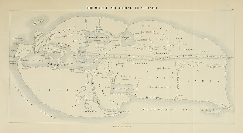
[編輯]| 描述 | 19th century reconstruction of World map according to Strabo (18 A.D.). | ||||||||||||||||||||||||||||||||||||||||||
| 日期 | |||||||||||||||||||||||||||||||||||||||||||
| 來源 | https://archive.org/download/historyofancient02bunb/historyofancient02bunb_orig_jp2.tar/historyofancient02bunb_orig_jp2%2Fhistoryofancient02bunb_orig_0271.jp2 | ||||||||||||||||||||||||||||||||||||||||||
| 作者 |
|
||||||||||||||||||||||||||||||||||||||||||
| 授權許可 (重用此檔案) |
Public domain | ||||||||||||||||||||||||||||||||||||||||||
| 其他版本 |
|
||||||||||||||||||||||||||||||||||||||||||


授權條款
[編輯]
|
本作品在其來源國以及其他版權期限是作者逝世後100年或以下的國家與地區屬於公有領域。 | |
| 此作品無已知的著作權限制,亦不受所有相關和鄰接的權利限制。 | |
檔案歷史
點選日期/時間以檢視該時間的檔案版本。
| 日期/時間 | 縮圖 | 尺寸 | 用戶 | 備註 | |
|---|---|---|---|---|---|
| 目前 | 2020年7月5日 (日) 15:03 | | 3,014 × 1,646(1.49 MB) | Sette-quattro(對話 | 貢獻) | higher quality image from https://archive.org/download/historyofancient02bunb/historyofancient02bunb_orig_jp2.tar/historyofancient02bunb_orig_jp2%2Fhistoryofancient02bunb_orig_0271.jp2 |
| 2008年2月29日 (五) 21:11 |  | 738 × 458(65 KB) | Anrie(對話 | 貢獻) | {{Information |Description=19th century reconstruction of World map according to Strabo (18 A.D.). |Source= [http://www.istrianet.org/istria/history/0000-0999AD/strabo/strabo-cartography.htm istrianet.org |Date=1800s (no exact date give) |Author= No autho |
無法覆蓋此檔案。
檔案用途
下列4個頁面有用到此檔案:
全域檔案使用狀況
以下其他 wiki 使用了這個檔案:
- af.wikipedia.org 的使用狀況
- ca.wikipedia.org 的使用狀況
- fy.wikipedia.org 的使用狀況
- kk.wikipedia.org 的使用狀況
- pl.wikipedia.org 的使用狀況