File:Ww2 europe map italy june until december 1944.jpg
跳至導覽
跳至搜尋

預覽大小:785 × 599 像素。 其他解析度:314 × 240 像素 | 629 × 480 像素 | 1,006 × 768 像素 | 1,265 × 966 像素。
原始檔案 (1,265 × 966 像素,檔案大小:1.89 MB,MIME 類型:image/jpeg)
說明
說明
添加單行說明來描述出檔案所代表的內容
摘要
[編輯]| 描述 |
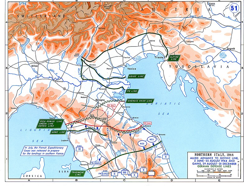
English: Allied Corp formations are depicted in blue. The German defensive lines are shown in green. The solid red line denotes the extent of the Allied advance by 29 August 1944, and the dotted red line is the extent of the Allied advance by 31 December 1944. |
| 日期 | |
| 來源 | Archive link to original website used for the map and the archive link to the map source page. |
| 作者 | The History Department of the United States Military Academy |
| 授權許可 (重用此檔案) |
US Government document |
| 其他版本 |
The current version of the map by the The History Department of the United States Military Academy: |

授權條款
[編輯]
|
|
 |
檔案歷史
點選日期/時間以檢視該時間的檔案版本。
| 日期/時間 | 縮圖 | 尺寸 | 使用者 | 備註 | |
|---|---|---|---|---|---|
| 目前 | 2021年2月20日 (六) 03:25 | | 1,265 × 966(1.89 MB) | Buidhe(留言 | 貢獻) | Reverted to version as of 14:07, 29 February 2020 (UTC) Not a minor change, should be uploaded as new file |
| 2021年2月20日 (六) 02:57 |  | 973 × 754(349 KB) | EnigmaMcmxc(留言 | 貢獻) | updated version of the map | |
| 2020年2月29日 (六) 14:07 |  | 1,265 × 966(1.89 MB) | Hohum(留言 | 貢獻) | Fix colour profile | |
| 2011年6月22日 (三) 18:21 |  | 1,265 × 966(1.93 MB) | Hohum(留言 | 貢獻) | Cleanup | |
| 2006年12月10日 (日) 12:26 |  | 1,265 × 966(2.01 MB) | MatthiasKabel(留言 | 貢獻) | == License information == {{PD-Layout}} {{PD-USGov}} Original from http://www.dean.usma.edu/history/web03/atlases/ww2%20europe/ww2%20europe%20war%20index.htm |
無法覆蓋此檔案。
檔案用途
下列6個頁面有用到此檔案:
全域檔案使用狀況
以下其他 wiki 使用了這個檔案:
- af.wikipedia.org 的使用狀況
- ar.wikipedia.org 的使用狀況
- cs.wikipedia.org 的使用狀況
- de.wikipedia.org 的使用狀況
- en.wikipedia.org 的使用狀況
- es.wikipedia.org 的使用狀況
- fi.wikipedia.org 的使用狀況
- fr.wikipedia.org 的使用狀況
- he.wikipedia.org 的使用狀況
- hu.wikipedia.org 的使用狀況
- id.wikipedia.org 的使用狀況
- it.wikipedia.org 的使用狀況
- ja.wikipedia.org 的使用狀況
- nl.wikipedia.org 的使用狀況
- no.wikipedia.org 的使用狀況
- pl.wikipedia.org 的使用狀況
- pt.wikipedia.org 的使用狀況
- ru.wikipedia.org 的使用狀況
- sk.wikipedia.org 的使用狀況
- sl.wikipedia.org 的使用狀況
- sr.wikipedia.org 的使用狀況
- sv.wikipedia.org 的使用狀況
- ta.wikipedia.org 的使用狀況
- uk.wikipedia.org 的使用狀況
- www.wikidata.org 的使用狀況
- zh.wikipedia.org 的使用狀況