File:Xinjiang nationalities by prefecture 2000.png
跳至導覽
跳至搜尋

預覽大小:725 × 600 像素。 其他解析度:290 × 240 像素 | 581 × 480 像素 | 929 × 768 像素 | 1,238 × 1,024 像素 | 1,474 × 1,219 像素。
原始檔案 (1,474 × 1,219 像素,檔案大小:129 KB,MIME 類型:image/png)
說明
說明
添加單行說明來描述出檔案所代表的內容
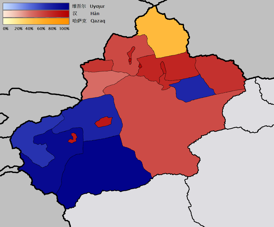
新疆地域按民族(民族)劃分的地圖。 2000年的人口普查信息來自w:en和w:de。 該地圖的基礎是Image:Bayin Gholin.png,但是我旋轉了地圖,使子午線更加接近垂直,並且還消除了背景噪音。 我從Image:Canada election 2006 v2.png中藉用了色階。 QuartierLatin196821:20,2006年1月28日(UTC)

|
本圖片是以PNG、GIF或JPEG格式上傳。然而,其中包含的資料或訊息,應該重新建立成可縮放向量圖形(SVG)檔案,以更有效率或更準確的方式儲存。如有可能,請上傳本圖片的SVG格式版本。在上傳之後,請修改維基各姊妹計畫中所有使用舊版圖片的條目(列在圖像連結章節中),替換為新版圖片,並在舊圖片的描述頁中加入{{Vector version available|新圖片名稱.svg}}模板,同時移除本模板。
|
摘要[編輯]
English: Map of the prefecture-level divisions of Xinjiang by ethnicity (nationality or 民族). 2000 census information is from w:en and w:de. The basis of the map is Image:Bayin Gholin.png, but I rotated the map so that the meridians are more nearly vertical, and also removed the background noise. I borrowed the colour scale from the Image:Canada election 2006 v2.png. QuartierLatin1968 21:20, 28 January 2006 (UTC)
Türkçe: Sincan'ın il düzeyi bölgelerindeki çoğunluğu oluşturan farklı etnik gruplar (minzu 民族). 2000 yılı nüfus verileri w:en ve w:de'den kaynaklanır. Haritanın temeli Image:Bayin Gholin.png'den alınmıştır, fakat meridyenleri daha dikey şekilde göstermek için harita döndürülmüştür ve gereksiz arka plan detayları çıkarılmıştır. Renk şeması Image:Canada election 2006 v2.png'den alınmıştır.
中文:新疆地域按民族(民族或民族)劃分的地圖。 2000年的人口普查信息來自w:en和w:de。 該地圖的基礎是Image:Bayin Gholin.png,但是我旋轉了地圖,使子午線更加接近垂直,並且還消除了背景噪音。 我從Image:Canada election 2006 v2.png中藉用了色階。 QuartierLatin196821:20,2006年1月28日(UTC)
授權條款[編輯]
我,本作品的著作權持有者,決定用以下授權條款發佈本作品:

|
已授權您依據自由軟體基金會發行的無固定段落、封面文字和封底文字GNU自由文件授權條款1.2版或任意後續版本,對本檔進行複製、傳播和/或修改。該協議的副本列在GNU自由文件授權條款中。 |
| 此檔案採用共享創意 姓名標示-相同方式分享 3.0 未在地化版本授權條款。 | ||
| ||
| 已新增授權條款標題至此檔案,作為GFDL授權更新的一部份。 |
您可以選擇您需要的授權條款。
檔案歷史
點選日期/時間以檢視該時間的檔案版本。
| 日期/時間 | 縮圖 | 尺寸 | 用戶 | 備註 | |
|---|---|---|---|---|---|
| 目前 | 2006年1月28日 (六) 21:43 | | 1,474 × 1,219(129 KB) | QuartierLatin1968(對話 | 貢獻) | adjusted Xizang/Qinghai boundary |
| 2006年1月28日 (六) 21:20 |  | 1,474 × 1,219(129 KB) | QuartierLatin1968(對話 | 貢獻) | * {{en}}: Map of the prefecture-level divisions of Xinjiang by ethnicity (nationality or 民族). 2000 census information is from w:en and w:de. The basis of the map is Image:Bayin Golin.png, but I rotated the map so that the meridians |
無法覆蓋此檔案。
檔案用途
下列4個頁面有用到此檔案:
全域檔案使用狀況
以下其他 wiki 使用了這個檔案:
- af.wikipedia.org 的使用狀況
- ast.wikipedia.org 的使用狀況
- azb.wikipedia.org 的使用狀況
- az.wikipedia.org 的使用狀況
- ba.wikipedia.org 的使用狀況
- bcl.wikipedia.org 的使用狀況
- bg.wikipedia.org 的使用狀況
- ca.wikipedia.org 的使用狀況
- da.wikipedia.org 的使用狀況
- de.wikipedia.org 的使用狀況
- en.wikipedia.org 的使用狀況
- eo.wikipedia.org 的使用狀況
- es.wikipedia.org 的使用狀況
- fr.wikipedia.org 的使用狀況
- gl.wikipedia.org 的使用狀況
- hr.wikipedia.org 的使用狀況
- incubator.wikimedia.org 的使用狀況
- ja.wikipedia.org 的使用狀況
- kk.wikipedia.org 的使用狀況
- la.wikipedia.org 的使用狀況
- lez.wikipedia.org 的使用狀況
- lv.wikipedia.org 的使用狀況
- mn.wikipedia.org 的使用狀況
- ms.wikipedia.org 的使用狀況
- nl.wikipedia.org 的使用狀況
- nn.wikipedia.org 的使用狀況
- no.wikipedia.org 的使用狀況
- oc.wikipedia.org 的使用狀況
- pt.wikipedia.org 的使用狀況
- ru.wikipedia.org 的使用狀況
檢視此檔案的更多全域使用狀況。