File:Yamagaru eki.jpg
Jump to navigation
Jump to search

Size of this preview: 600 × 600 pixels. Other resolutions: 240 × 240 pixels | 480 × 480 pixels | 768 × 768 pixels | 1,028 × 1,028 pixels.
Original file (1,028 × 1,028 pixels, file size: 967 KB, MIME type: image/jpeg)
Captions
Captions
Add a one-line explanation of what this file represents
Summary[edit]
| Description |
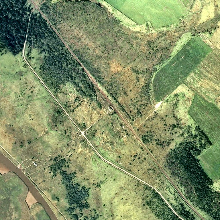
日本語: 天北線(廃線)山軽駅 1977年。周囲約1km範囲。左上が南稚内方面。無人化された後の姿で、既に棒線化されているが、かつては相対式ホーム2面2線に副本線と駅舎横の貨物引込み線、駅裏に広いストックヤードを有する普通の駅だった。
戦前から戦後すぐにかけての木材需要と、終戦直後の食糧難時代の農業開拓者受入事業によって集落が形成されたが、木材需要の低迷と農業に適さない気候風土によって、昭和40年代の高度経済成長期に入ると一気に過疎化し、無人地帯となった。この時点では木造駅舎はそのまま残されているが、後年プレハブの待合室に置き換えられている。 |
| Date | |
| Source | 国土交通省 国土画像情報(カラー空中写真)を基に作成 |
| Author | Nisanyongo |
| Permission (Reusing this file) |
下記を参照して下さい |
Licensing[edit]

|
The copyright holder of this file, the Ministry of Land, Infrastructure, Transport and Tourism of Japan, allows anyone to use it for any purpose, provided that the copyright holder is properly attributed. Redistribution, derivative work, commercial use, and all other use is permitted. |
Attribution:
Copyright © National Land Image Information (Color Aerial Photographs), Ministry of Land, Infrastructure, Transport and Tourism
|
 |
This image is copyrighted by the Ministry of Land, Infrastructure, Transport and Tourism of Japan. For terms of use, see the stipulation to use of National Land Information (in Japanese) and message from MLIT (in Japanese and English). When you display this image on an article, include the following phrase in the description: "Made based on National Land Image Information (Color Aerial Photographs), Ministry of Land, Infrastructure, Transport and Tourism".
|
File history
Click on a date/time to view the file as it appeared at that time.
| Date/Time | Thumbnail | Dimensions | User | Comment | |
|---|---|---|---|---|---|
| current | 09:43, 29 January 2010 | | 1,028 × 1,028 (967 KB) | Nisanyongo (talk | contribs) | 天北線(廃線)山軽駅 1977年。周囲約1km範囲。左上が南稚内方面。無人化された後の姿で、既に棒線化されているが、かつては相対式ホーム2面2線に副本線と駅舎横の貨物引込み線、駅裏� |
You cannot overwrite this file.
File usage on Commons
There are no pages that use this file.
File usage on other wikis
The following other wikis use this file: