File:Yann Nguema et EZ3kiel, Évolutions, 2017 (33015176242).jpg

Original file (4,576 × 3,056 pixels, file size: 3.13 MB, MIME type: image/jpeg)
Captions
Captions
Summary
[edit].jpg&action=edit§ion=1)
| Description |
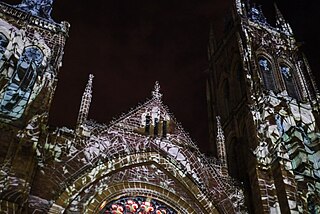
Église Saint-James, Montréal Illuminart est un nouveau circuit alliant art, lumière et technologie déployé dans le centre-ville montréalais. S’adressant à un public curieux de découvertes et d’exploration, Illuminart rassemble des projets d’artistes, de créateurs, d’ingénieurs, de scénographes, de graphistes et de vidéastes venus d’ici et d’ailleurs. L’espace urbain s’illumine, s’anime et devient un rendez-vous de créativité, d’inspiration et de partage grâce à des œuvres tantôt surprenantes, impressionnantes ou amusantes. Pour sa première édition qui a lieu du 22 février au 11 mars 2017, Illuminart présente 25 œuvres dans un parcours de 3,6 km dans le Quartier des spectacles. Conçu en collaboration artistique avec Lyon, le parcours accueille notamment 6 projets qui ont été présentés lors de la dernière édition de la Fête des Lumières. 2 - Évolutions Un souffle numérique déconstruit et reconstruit l’Église Saint-James… Sous les projections et les lasers, la pierre devient mouvante et l’architecture se plie aux caprices de la physique et de la magie ! Une épopée poétique où patrimoine et technologie se croisent.
Yann Nguema, EZ3kiel France Formé en 1993, le groupe EZ3kiel (France) est réputé pour ses créations visuelles et sonores alliant poésie, pierres et futurisme. Responsable de l’ensemble de la production visuelle du groupe, Yann Nguema axe son travail sur le spectacle vivant avec une constante recherche autour de l’association image-musique. <a href="http://experienceilluminart.com/fr-CA/Projets" rel="nofollow">experienceilluminart.com/fr-CA/Projets</a> |
| Date | |
| Source | Yann Nguema et EZ3kiel, Évolutions, 2017 |
| Author | art_inthecity from Montréal, CA |
| Camera location | | View this and other nearby images on: OpenStreetMap |
|---|
.jpg¶ms=045.505245_N_-073.568249_E_globe:Earth_type:camera_source:Flickr_&language=en)
Licensing
[edit].jpg&action=edit§ion=2)
- You are free:
- to share – to copy, distribute and transmit the work
- to remix – to adapt the work
- Under the following conditions:
- attribution – You must give appropriate credit, provide a link to the license, and indicate if changes were made. You may do so in any reasonable manner, but not in any way that suggests the licensor endorses you or your use.
| This image was originally posted to Flickr by art_inthecity at https://flickr.com/photos/57286185@N04/33015176242 (archive). It was reviewed on 6 May 2019 by FlickreviewR 2 and was confirmed to be licensed under the terms of the cc-by-2.0. |
File history
Click on a date/time to view the file as it appeared at that time.
| Date/Time | Thumbnail | Dimensions | User | Comment | |
|---|---|---|---|---|---|
| current | 15:17, 6 May 2019 | | 4,576 × 3,056 (3.13 MB) | Mindmatrix (talk | contribs) | Transferred from Flickr via #flickr2commons |
You cannot overwrite this file.
File usage on Commons
There are no pages that use this file.
.jpg&oldid=878758890)