File:Z3qb8xapg7k51.png
Jump to navigation
Jump to search

Size of this preview: 800 × 480 pixels. Other resolutions: 320 × 192 pixels | 1,024 × 614 pixels | 1,280 × 768 pixels | 2,560 × 1,535 pixels | 4,386 × 2,630 pixels.
Original file (4,386 × 2,630 pixels, file size: 295 KB, MIME type: image/png)
Captions
Captions
Add a one-line explanation of what this file represents

|
This locator map image could be re-created using vector graphics as an SVG file. This has several advantages; see Commons:Media for cleanup for more information. If an SVG form of this image is available, please upload it and afterwards replace this template with
{{vector version available|new image name}}.
It is recommended to name the SVG file “Z3qb8xapg7k51.svg”—then the template Vector version available (or Vva) does not need the new image name parameter. |
Summary[edit]
| Description |
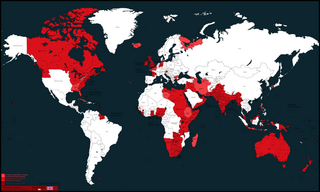
English: map |
| Date | |
| Source | Own work |
| Author | Ronnie Tang 221 |
Licensing[edit]
I, the copyright holder of this work, hereby publish it under the following license:
This file is licensed under the Creative Commons Attribution-Share Alike 4.0 International license.
- You are free:
- to share – to copy, distribute and transmit the work
- to remix – to adapt the work
- Under the following conditions:
- attribution – You must give appropriate credit, provide a link to the license, and indicate if changes were made. You may do so in any reasonable manner, but not in any way that suggests the licensor endorses you or your use.
- share alike – If you remix, transform, or build upon the material, you must distribute your contributions under the same or compatible license as the original.
File history
Click on a date/time to view the file as it appeared at that time.
| Date/Time | Thumbnail | Dimensions | User | Comment | |
|---|---|---|---|---|---|
| current | 14:53, 8 September 2023 | | 4,386 × 2,630 (295 KB) | Atavoidturk (talk | contribs) | Fixed colors |
| 14:50, 8 September 2023 |  | 4,386 × 2,630 (294 KB) | Atavoidturk (talk | contribs) | Fixed colors | |
| 15:29, 24 July 2023 |  | 4,386 × 2,630 (507 KB) | Randomastwritter (talk | contribs) | corrected Nugaal border | |
| 15:29, 21 August 2022 |  | 4,386 × 2,630 (506 KB) | Ronnie Tang 221 (talk | contribs) | Uploaded while editing "Territorial evolution of the British Empire" on en.wikipedia.org |
You cannot overwrite this file.
File usage on Commons
There are no pages that use this file.