File:Zugbrücke aus Ouderkerk aan de Amstel.jpg

Original file (4,608 × 3,456 pixels, file size: 3.06 MB, MIME type: image/jpeg)
Captions
Captions
Summary
[edit]
| Description |
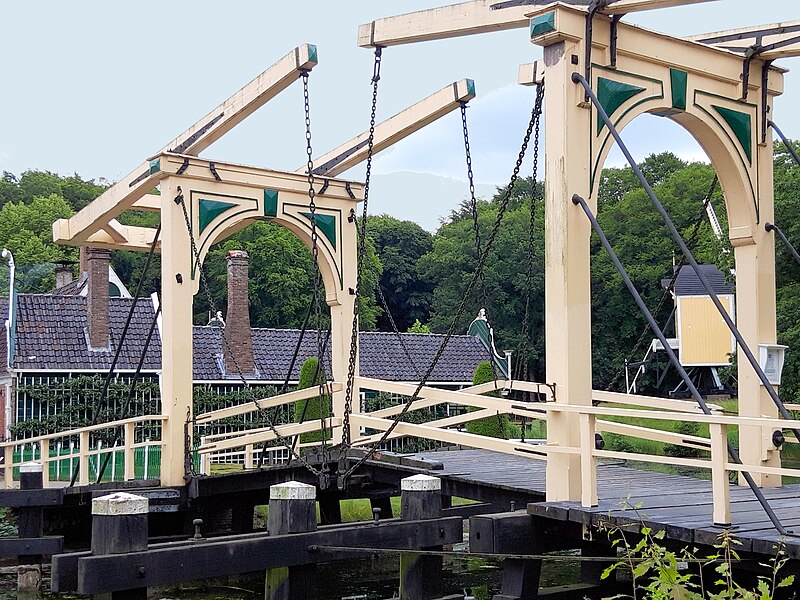
Deutsch: Zugbrücke im Openluchtmuseum, Arnheim |
| Date | |
| Source | Own work |
| Author | Viola sonans |
| Camera location | | View this and other nearby images on: OpenStreetMap |
|---|
Licensing
[edit]
- You are free:
- to share – to copy, distribute and transmit the work
- to remix – to adapt the work
- Under the following conditions:
- attribution – You must give appropriate credit, provide a link to the license, and indicate if changes were made. You may do so in any reasonable manner, but not in any way that suggests the licensor endorses you or your use.
- share alike – If you remix, transform, or build upon the material, you must distribute your contributions under the same or compatible license as the original.
Text on blackboard: Drawbridge Ouderkerk aan de Amstel, 19th century Bridge duty also for pedestrians On one of the pillars of the big one wooden bridge gates hang a price list from 1771. On it is specified exactly what a Bridge passage this year costs. Skippers pay, of course for opening the bridge. But also pedestrians, the bridge want to cross, pay one Inch. The bridge guard opens the Bridge by pulling on chains. The Counterweights cause the Bridge doors pull up easily to let. To close the bridge the bridge guard runs on one the flaps. The bridge will be then pressed by his weight. On Predecessor of this bridge is already 1358 of Duke Aalbrecht in one Pfandbrief mentions: "(...) the village at Ouder-Aemstel on both sides of the Bridge (...) ".}}
Text auf der Tafel: Zugbrücke, Ouderkerk aan de Amstel, 19. Jh m. Brückenzoll auch für Fußgänger. Auf einem der Pfosten der großen hölzernen Brückentore hängt eine Preisliste von 1771. Darauf ist genau angegeben, was eine Brückenpassage in diesem Jahr kostet. Schiffsführer zahlen natürlich für das Öffnen der Brücke. Aber auch Fußgänger, die die Brücke überqueren möchten, zahlen einenZoll. Der Brückenwächter öffnet die Brücke, indem er an Ketten zieht. Die Gegengewichte bewirken, dass die Brückenklappen sich leicht heraufziehen lassen. Zum Schließen der Brücke läuft der Brückenwächter auf eine der Klappen. Die Brücke wird dann durch sein Gewicht zugedrückt. Ein Vorgänger dieser Brücke wird bereits 1358 von Herzog Aalbrecht in einem Pfandbrief erwähnt: "( ... ) das Dorf bei Ouder-Aemstel zu beiden Seiten der Brücke ( ... )".
File history
Click on a date/time to view the file as it appeared at that time.
| Date/Time | Thumbnail | Dimensions | User | Comment | |
|---|---|---|---|---|---|
| current | 06:46, 13 July 2019 | | 4,608 × 3,456 (3.06 MB) | Viola sonans (talk | contribs) | User created page with UploadWizard |
You cannot overwrite this file.
File usage on Commons
There are no pages that use this file.
File usage on other wikis
The following other wikis use this file:
- Usage on de.wikipedia.org