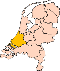
File:Zuid-Holland position.svg

原始檔案 (SVG 檔案,表面大小:200 × 236 像素,檔案大小:158 KB)
說明
說明
摘要
[編輯]| 描述Zuid-Holland position.svg | Location of the province of South-Holland (South Holland) in the Netherlands. |
| 日期 | |
| 來源 | Own work, based on freely available GIS data |
| 作者 | User:Mtcv |
| 授權許可 (重用此檔案) |
Data: attribution required; my work: PD |
| 其他版本 | I attempted to make an svg version of Image:Zuid Holland-Position.png (with less simplified boundaries) |
Clickable version
[編輯]
授權條款
[編輯]
|
本檔案的著作權持有者,Centraal Bureau voor de Statistiek,在註明所有人姓名的前提下,允許任何人使用本檔案於任何用途。包含再散布、衍生作品、商業用途及其他用途。 |
|
Attribution |
|
本作品為自由作品,可以讓任何人以任何目的使用本作品。如果您希望使用本內容,只要遵循本頁面所提到的任何著作權要求即可,而不需要請求許可。
維基媒體收到了一封電子郵件,確認著作權持有者已根據本頁面上所述的條款釋出。此郵件由一位VRT志工審查並儲存在我們的許可檔案中,獲得授權的志工可以 在工單編號#2007041210008226查看該郵件。 如果您對於該存檔郵件有疑問,請使用VRT公告板。
工單連結: https://ticket.wikimedia.org/otrs/index.pl?Action=AgentTicketZoom&TicketNumber=2007041210008226
|
| This image is (in part or entirely) based on geographical data from Statistics Netherlands (Centraal Bureau voor de Statistiek). Digital geometry files in ESRI format can be downloaded from their website [1].
In particular, boundary data of statistical districts is based on either the Wijk- en buurtkaart 2005, or the Wijk- en buurtkaart 2003 ("CBS/TOPgrenzen"). Data on localities (bevolkingskernen) are from the publication Bevolkingskernen in Nederland 2001. Conditions of use (in Dutch):
Unless otherwise specified, data on waterways and lakes are from the public domain Digital Chart of the World. |
| 註解 InfoField | 該圖片含有註解:在維基媒體共享資源上查看註解 |
檔案歷史
點選日期/時間以檢視該時間的檔案版本。
| 日期/時間 | 縮圖 | 尺寸 | 用戶 | 備註 | |
|---|---|---|---|---|---|
| 目前 | 2019年3月2日 (六) 17:21 |  | 200 × 236(158 KB) | Thayts(對話 | 貢獻) | update |
| 2006年10月3日 (二) 00:49 |  | 200 × 236(158 KB) | Mtcv(對話 | 貢獻) | {{Information| |Description=Location of the province of Noord-Holland (North Holland) in the Netherlands. |Source=Own work, based on freely available GIS data |Date=2006-10-03 |Author=User:Mtcv |Permission=Data: attribution required; my work: PD |othe |
無法覆蓋此檔案。
檔案用途
下列14個頁面有用到此檔案:
- Maps of the Netherlands
- File:Drenthe position.svg
- File:Flevoland position.svg
- File:Friesland position.svg
- File:Gelderland position.svg
- File:Groningen position.svg
- File:Limburg position.svg
- File:Noord-Brabant position.svg
- File:Noord-Holland position.svg
- File:Overijssel position.svg
- File:Provinces of the Netherlands.svg
- File:Utrecht position.svg
- File:Zeeland position.svg
- File:Zuid-Holland position.svg
全域檔案使用狀況
以下其他 wiki 使用了這個檔案:
- ar.wikipedia.org 的使用狀況
- روتردام
- لاهاي
- جنوب هولندا
- لايدن
- دلفت
- خاودا
- زوترمير
- سخيدام
- قالب:بلديات جنوب هولندا
- خوريكوم
- خوريه- أوفرفلاكيه
- كاتفايك
- ماسلاوس
- فلاردينجن
- دوردريخت
- ليسه
- ألبلاسردام
- ألبراندزفارد
- ألفن آن دن راين
- باريندريخت
- كرمبنيرفارد
- نيسافارد
- بيننيماس
- بوديخرافن-ريودايك
- بريله
- كابيلا آن دن آيسل
- كرومستراين
- خيسينلاندن
- هاردينكسفيلد- خيسيندام
- هيليفوتسلاوس
- هندريك- إيدو- أمباخت
- هيليخوم
- كاخ آن براسم
- كوريندايك
- كريمبن آن دن آيسل
- لانسينجيرلاند
- ليردام
- لايدردورب
- لايتسيندام- فوربورخ
- ميدن- دلفلاند
- مولنفارد
- نيوكوب
- نوردفايك
- نوردفايكرهاوت
- أوخستخيست
- آود- بايرلاند
- آودركيرك
- بابندريخت
- باين آكر- نوتدورب
- ريدركيرك
檢視此檔案的更多全域使用狀況。
詮釋資料
此檔案中包含其他資訊,這些資訊可能是由數位相機或掃描器在建立或數位化過程中所新增的。若檔案自原始狀態已被修改,一些詳細資料可能無法完整反映出已修改的檔案。
| 寬度 | 200 |
|---|---|
| 高度 | 236 |


