File:Östra Ramdala.svg
Jump to navigation
Jump to search

Size of this PNG preview of this SVG file: 742 × 599 pixels. Other resolutions: 297 × 240 pixels | 594 × 480 pixels | 951 × 768 pixels | 1,268 × 1,024 pixels | 2,535 × 2,048 pixels | 5,457 × 4,408 pixels.
Original file (SVG file, nominally 5,457 × 4,408 pixels, file size: 2.43 MB)
Captions
Captions
Add a one-line explanation of what this file represents
| Description |
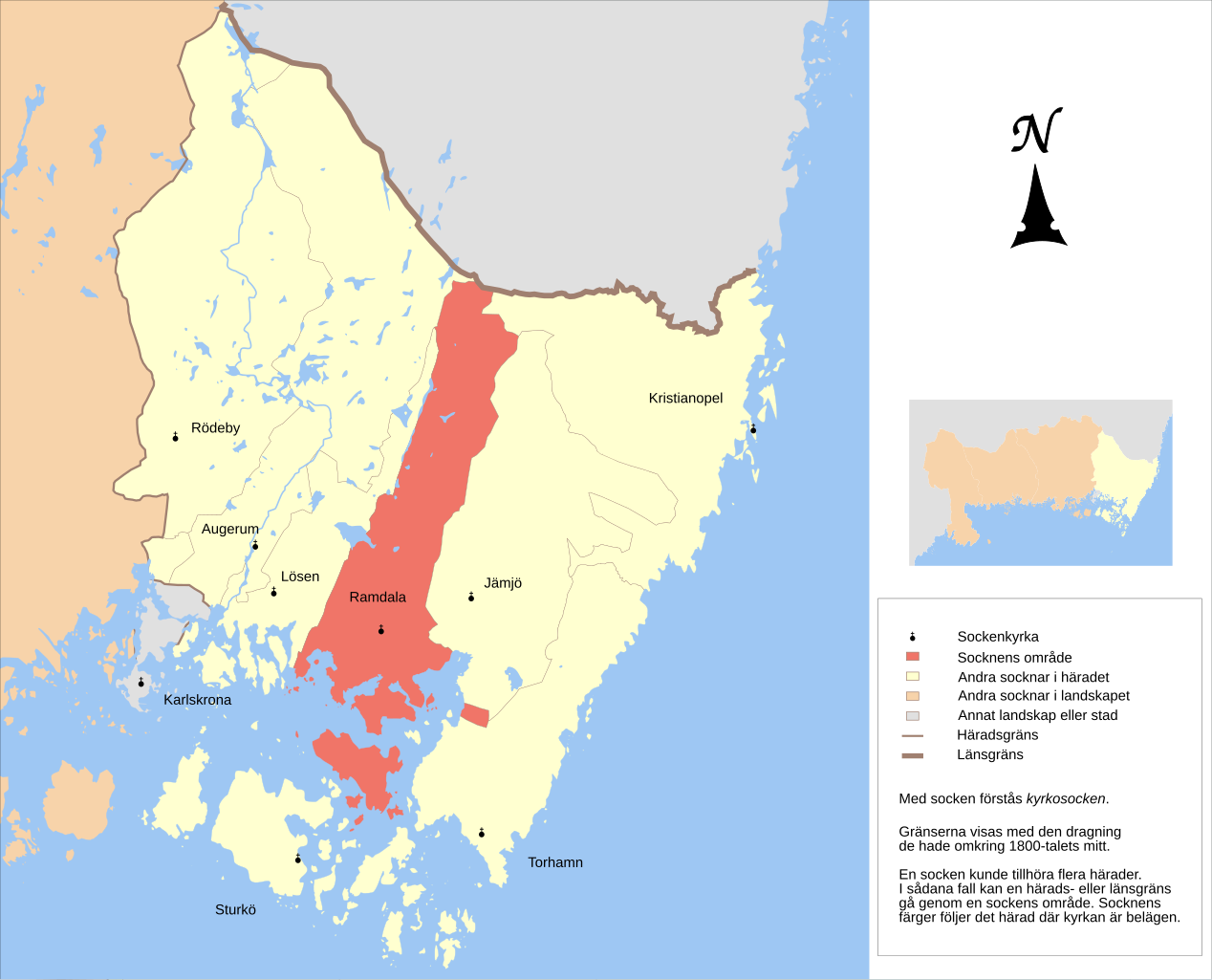
English: Map showing the borders of the civil parish of Ramdala in the hundred of Östra, Blekinge County, Blekinge Region of Sweden. Circa 1850-1900. |
| Date | (UTC) |
| Source | |
| Author |
|
| Other versions |
Derivative works of this file: |
| This is a retouched picture, which means that it has been digitally altered from its original version. Modifications: Combined maps and cut out Östra härad, marked Ramdala parish. The original can be viewed here: GS Ottenby.svg:
|
This file is licensed under the Creative Commons Attribution-Share Alike 3.0 Unported license.
- You are free:
- to share – to copy, distribute and transmit the work
- to remix – to adapt the work
- Under the following conditions:
- attribution – You must give appropriate credit, provide a link to the license, and indicate if changes were made. You may do so in any reasonable manner, but not in any way that suggests the licensor endorses you or your use.
- share alike – If you remix, transform, or build upon the material, you must distribute your contributions under the same or compatible license as the original.
Original upload log[edit]
This image is a derivative work of the following images:
- File:GS_Karlskrona.svg licensed with Cc-by-3.0
- 2010-11-06T08:27:27Z Edaen 5943x4457 (713103 Bytes) {{Information |Description={{en|1=Map showing borders of parishes and hundreds in the vicinity of Karlskrona, based on information from map by Topografiska Corpsen. '''11. Karlskrona''' Topografiska Corpsens karta öfver S
- File:GS_Ottenby.svg licensed with Cc-by-3.0
- 2010-11-15T11:41:19Z Edaen 5781x4433 (62482 Bytes) {{Information |Description={{en|1=Map showing borders of parishes and hundreds in the vicinity of Ottenby, based on information from map by Topografiska Corpsen. ''''''Ottenby''' Grav. af Hagstrand och Herlin. Topografisk
Uploaded with derivativeFX
File history
Click on a date/time to view the file as it appeared at that time.
| Date/Time | Thumbnail | Dimensions | User | Comment | |
|---|---|---|---|---|---|
| current | 15:55, 9 June 2011 | | 5,457 × 4,408 (2.43 MB) | Edaen (talk | contribs) | Reverted to version as of 10:57, 7 June 2011 |
| 10:51, 8 June 2011 |  | 5,457 × 4,408 (2.43 MB) | Edaen (talk | contribs) | Reverted to version as of 17:03, 2 June 2011 | |
| 10:57, 7 June 2011 |  | 5,457 × 4,408 (2.43 MB) | Edaen (talk | contribs) | changed colours in the small map | |
| 17:03, 2 June 2011 |  | 5,457 × 4,408 (2.43 MB) | Edaen (talk | contribs) | Removed map of Sweden | |
| 16:17, 2 June 2011 |  | 5,458 × 4,410 (2.49 MB) | Edaen (talk | contribs) | Added small maps | |
| 10:58, 22 April 2011 |  | 4,490 × 4,408 (373 KB) | Edaen (talk | contribs) | {{Information |Description={{en|1=Map showing borders of parishes and hundreds in the vicinity of Karlskrona, based on information from map by Topografiska Corpsen. <small>'''11. Karlskrona''' Topografiska Corpsens karta öfver Sverige 1870. (Uppmätt 1 |
You cannot overwrite this file.
File usage on Commons
The following 8 pages use this file:
File usage on other wikis
The following other wikis use this file:
- Usage on sv.wikipedia.org
- Usage on www.wikidata.org