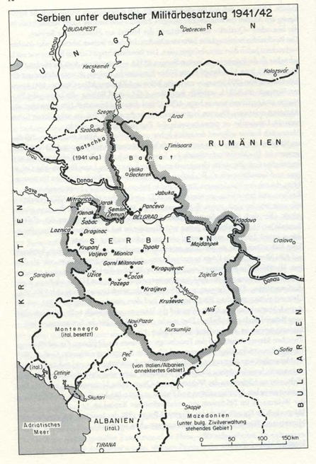
File talk:Serbia1941 1944.png
 | 这个file曾于02 September 2007被提出存废讨论,讨论结果为保留。 如果您认为需要再度提出存废讨论,请先参阅该讨论页。 |
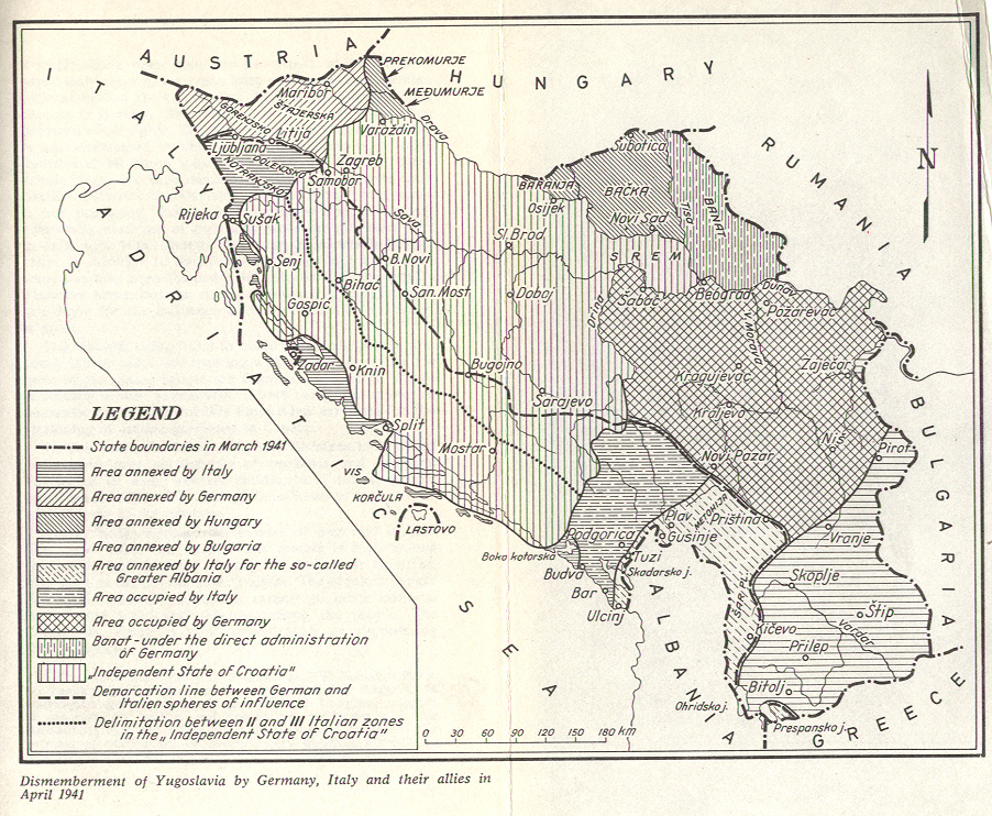
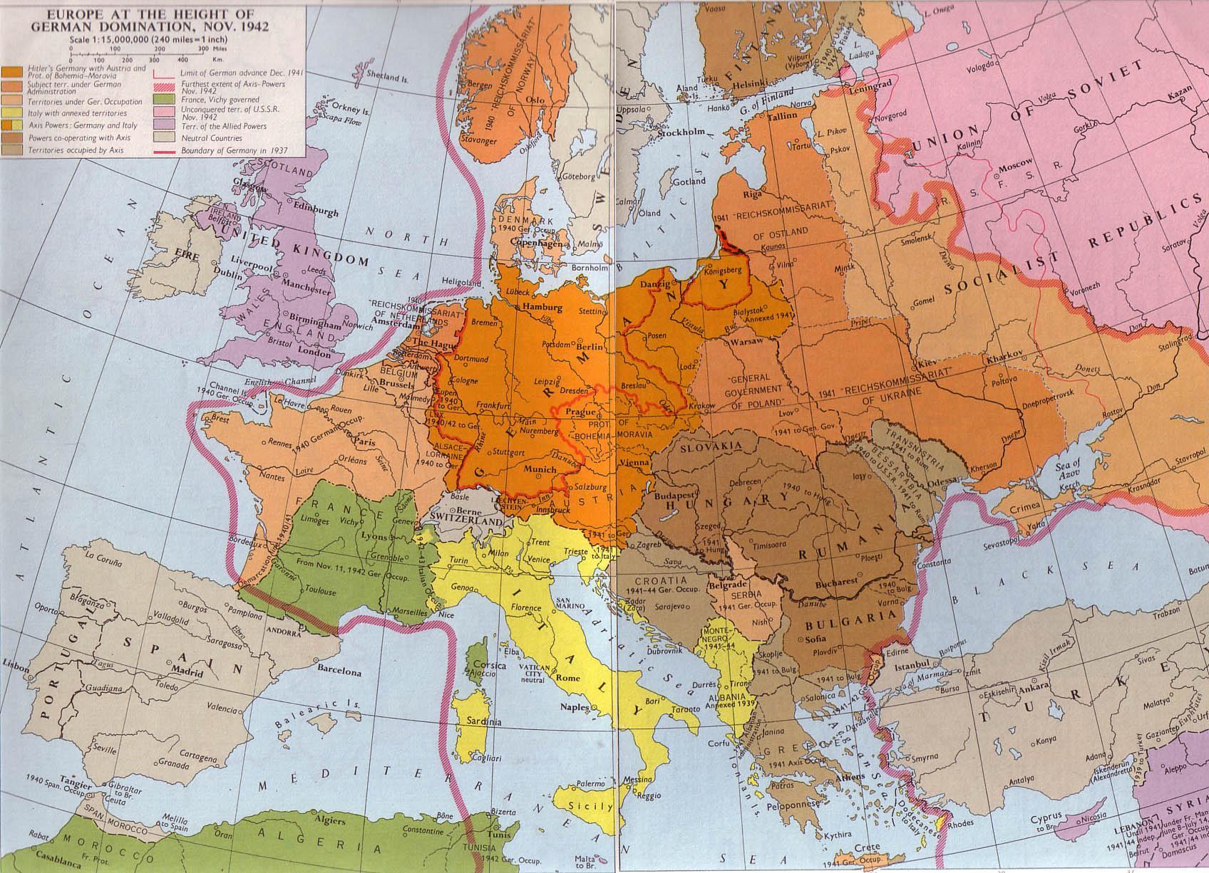
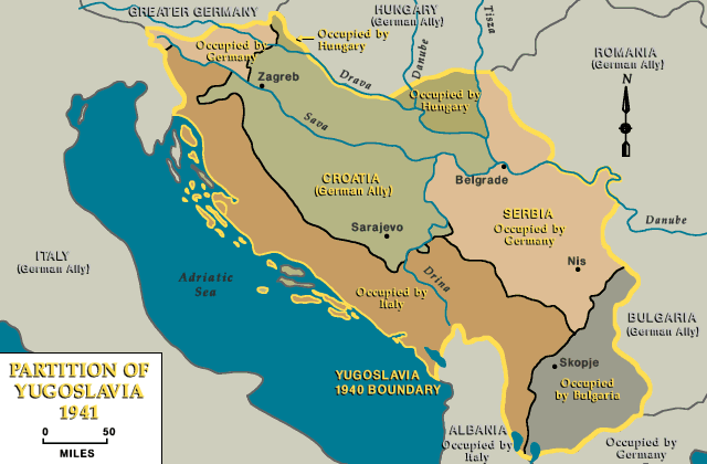
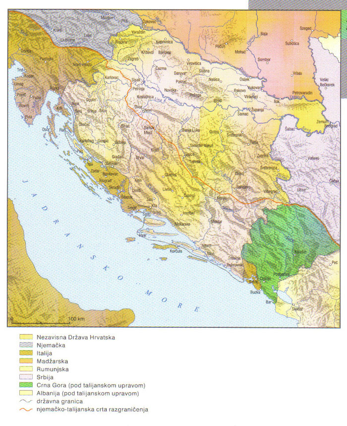
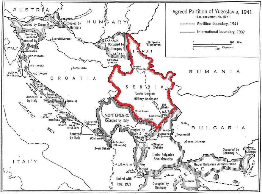
It seems that Banat was not under Serbian but under direct German jurisdiction.
http://www.muzejavnoj.ba/virtuelna-tura/ulaznihol/pocetak-rata/
http://www.marxists.org/subject/yugoslavia/images/maps/1941-dismemberment.jpg
http://terkepek.adatbank.transindex.ro/kepek/netre/211.gif --Mladifilozof (talk) 20:56, 19 November 2013 (UTC)
- That mean "direct jurisdiction of German minority in Banat". Officially, Banat was autonomous region of Serbia. Read this book for info: http://www.helsinki.org.rs/serbian/doc/Ogledi07.pdf
- page 22: Nedićeva vlada je potpisivala i odluke po kojima za državljane Rajha nije važilo ograničenje dozvole za rad u Srbiji, po kojima su sve diplome Rajha priznavane bez nostrifikacije, ili npr. po kojima su gradovi u Banatskom okrugu umesto srpskih dobijali nemačka imena.
- page 191: PROMENA IMENA MESTA – Po molbi Odbora Opštine Banatski Karlovac […] rešavam: Da se dosadanje ime mesta Banatski Karlovac, Sreza belocrkvanskog, Dunavske banovine promeni u ’Karlsdorf’. (Milan Nedić s. r. Službene novine, 14. novembar 1941.)
- page 269: PROMENA IMENA MESTA U OKRUGU BANATSKOM
- So, according to these documents, Banat was under jurisdiction of government of Milan Nedić. Anyway, that is just one example. You also have many maps which are showing Banat within Serbia:
- http://www.srpska-mreza.com/MAPS/Yugoslavia/YU-Nazi-division.jpg
- http://www.conflicts.rem33.com/images/deut/nazi_europe.jpg
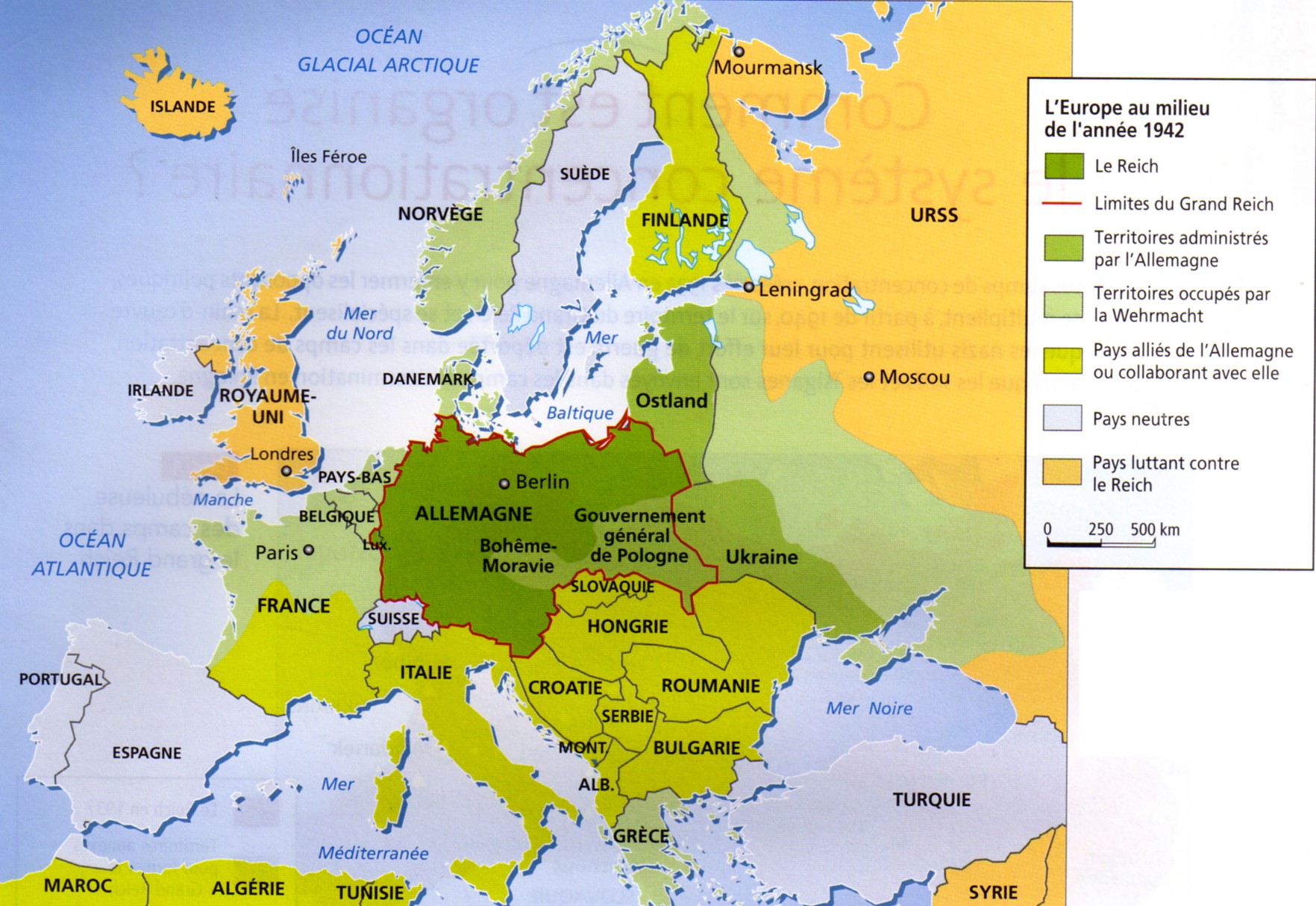
- http://faculty.unlv.edu/pwerth/Europe-1942.jpg
- http://www.ushmm.org/lcmedia/map/lc/image/yug71020.gif
- http://www.cartoko.com/content/wp-content/uploads/2010/05/Yugoslavia_1992_p038_CtryStudy.jpg
- http://www.emperors-clothes.com/croatia/cmap324.jpg
- http://www.hervardi.com/images/ndh_1941_1943.jpg
- http://img25.imageshack.us/img25/1898/mapairfieldsrumaniasmall5xn.jpg
- http://freepages.genealogy.rootsweb.ancestry.com/~atpc/graphic/map-europe-1942.gif
- http://faculty.unlv.edu/pwerth/Europe-East-Central-1939-42.jpg
- http://cfluckiger.yolasite.com/resources/europe%201942.jpg
- http://www.citinet.net/ak/img/europe-1942.jpg
- http://rene.corti.pagesperso-orange.fr/histoire/mineures/europe42/europe42.jpg
- http://static1.assistancescolaire.com/ele/images/fde07hi09i01.png
- http://home.versatel.nl/gerardvonhebel/germany1943.GIF
- http://www.skidmore.edu/~rginsber/go-201/Europe1943.gif
- http://www.histoirealacarte.com/images/cartes_fixes/tome3/europe-janv1943.gif
- http://home.zonnet.nl/gerardvonhebel/euro1943.GIF
- http://www.atlas-historique.net/cartographie/1914-1945/grand_format/Europe1943GF.gif
- http://www.open.ac.uk/socialsciences/semlin/a/images/holocaust-chronology/map.jpg
- http://eba-www.yokohama-cu.ac.jp/~kogiseminagamine/img286SerbienManoschek1.jpg
- http://p1.grando.hu/photos/6b/00/6b95_1_1600.jpg
- http://crowland.uw.hu/images/csata/delvidek_02.jpg
- http://szebbjovo.hu/images/2011/04/delvidek.jpg
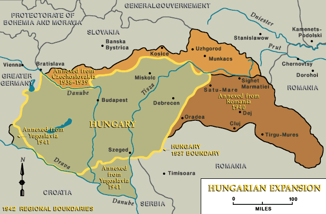
- http://www.ushmm.org/lcmedia/map/lc/image/hun71060.gif
- http://m.cdn.blog.hu/ha/hajdusag/image/HUN1941_v2.jpg
- http://www.centarzaedukaciju.com/austria/Slike/Karta%2041-45.png
- http://thomas-sz.com/web_adel/csaky/bilder/beruehmte_ahnen/istvan_miniszter/magyarorszag_1941_550px.gif
- http://www.ushmm.org/lcmedia/map/lc/image/eur66830.gif PANONIAN (talk) 12:51, 20 November 2013 (UTC)
Map of Nedić Serbia from official military atlas[编辑]

I see that you have many links for your map, but few valid sources would be enough. I have an old military atlas, published in Belgrade in 1952. According to the atlas, occupied Serbia was without Banat. I don't know what was the situation then, but I believe that experts from Geography institute ("Geografski institut JNA") knew the situation better then me and you. --Mladifilozof (talk) 15:36, 8 December 2013 (UTC)
- That is just mistake in presentation in that atlas. Banat was part of Serbia and there is no any textual source that explicitly claiming anything opposite. That atlas was meant to be used as a graphical illustration of textual info. I suppose that authors of the atlas were not aware that somebody will misinterpret that info like this. They only aimed to show that Banat was under different administration than rest of Serbia. Textual sources are explicitly claiming that Banat was established as autonomous region within Serbia. See this one as example: [1] - Quote: "Nedić's Serbia included the Banat region of Vojvodina, containing a population of 640,000 (including about 130,000 Volksdeutsche). On June 5, 1941, Banat was accorded an autonomous status". There is no source which says that this autonomous status was changed during the war. However, the "autonomy" of Banat was in fact very significant and Banat was something like a "state inside a state". Government of Milan Nedić had very little authority in Banat, whose local German authorities de facto were in almost total control. However, it was a "de jure" part of Serbia, although "de facto" it was almost a separate state - that was meant to be presented in mentioned atlas. PANONIAN (talk) 21:16, 8 December 2013 (UTC)
- Here is a detailed description of status of Banat: http://www.doiserbia.nb.rs/img/doi/0350-7599/2012/0350-75991202093J.pdf (page 94 - The question of the Banat). Quote (from page 97): "The Banat enjoyed autonomy from the rest of Serbia and was put first under a vice-banus, and during the administrative reorganization of the country on December 18, 1941, it became one of 14 counties (okrug)." PANONIAN (talk) 09:26, 9 December 2013 (UTC)