Ilford Road Metro station
Jump to navigation
Jump to search
English: Ilford Road 55°00′00″N 1°36′39″W / 55°N 1.6108°W is a station on the Green & Yellow Lines of the Tyne and Wear Metro.
| Opened | New or converted |
Number of platforms | Track alignment | Tyne & Wear metropolitan borough |
| 11 August 1980 | New | 2 | NNE-SSW | Newcastle upon Tyne |
| Layout | ||||
| Two side platforms in a cutting, with platform level station buildings in the northern half | ||||
| Platform no. and position |
Direction of travel |
Previous stop |
Route | Next stop |
| Platform 1 East |
Southbound | South Gosforth | Yellow Line to South Shields (stop 25 of 42) | West Jesmond |
| Green Line to South Hylton (stop 09 of 31) | ||||
| Platform 2 West |
Northbound | West Jesmond | Yellow Line to St James (stop 18 of 42) | South Gosforth |
| Green Line to Airport (stop 23 of 31) | ||||
| Notes | ||||
| None | ||||
| Station buildings | ||||
| Two simple rectangular structures in the original style, both 20' by 10' | ||||
| Access | ||||
| Sloped paths down to platform level from parallel streets, Ilford Road to the west, Albury Road/Woodthorne Road to the east, with both roads running south to an E-W bridge for Moorfield Road, 300' south of the platform ends | ||||
| Protection from the elements | ||||
| 60' platform shelters attached to the front of both station buildings | ||||
| Interchanges | ||||
| None | ||||
-
 The view north to the station from the Moorfield Road bridge; Metrocar 4010 is loading in Platform 1, en route to Park Lane
5 May 2008 -
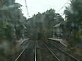 The view from the front of Metrocar No. 4089 as it approaches Platform 1, en route to South Hylton
10 October 2005 -
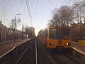 The view from the front of a Metrocar as it approaches Platform 2, en route to Airport, while another stands in Platform 1 en route to Pelaw
1 March 2010


