File:Вугленосні райони Донбасу.svg
Jump to navigation
Jump to search

Size of this PNG preview of this SVG file: 800 × 347 pixels. Other resolutions: 320 × 139 pixels | 640 × 278 pixels | 1,024 × 444 pixels | 1,280 × 556 pixels | 2,560 × 1,111 pixels | 28,800 × 12,500 pixels.
Original file (SVG file, nominally 28,800 × 12,500 pixels, file size: 37 KB)
Captions
Captions
Add a one-line explanation of what this file represents
Summary[edit]
| Description |
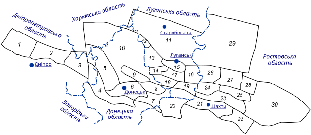
Українська: Карта вугленосних районів Донбасу Схема розташування вугленосних районів Донецького басейну: 1 — Петриковський, 2 — Новомосковський, 3 — Петропавлівський, 4 — Південно–Донбаський, 5 — Покровський, 6 — Донецько–Макіївський, 7 — Амвросієвський, 8 — Торезько–Сніжнянський; 9 — Центральний, 10 — Північно-західні окраїни Донбасу; 11 — Старобельська площа, 12 — Лисичанський; 13 — Алмазно–Мар'ївський; 14 — Селезнівський, 15 — Луганський, 16 — Краснодонський; 17 — Ореховський; 18 — Боково–Хрустальський; 19 — Должансько–Ровенецький; 20 — Міуський, 21 — Шахтинсько–Несвітаєвський; 22 — Задонський, 23 — Суліна–Садкінський; 24 — Гуково–Звєрєвський; 25 — Червонодонецький; 26 — Каменсько–Гундорівський; 27 — Білокалітвенський; 28 — Тадинський; 29 — Міллєровський; 30 — Цимлянський. |
| Date | |
| Source | Юровский А. З. Сера каменных углей — М.: 1960. — 295 с. |
| Author | Leon II |
| Permission (Reusing this file) |
This file is licensed under the Creative Commons Attribution-Share Alike 3.0 Unported license.
|
| SVG development |
File history
Click on a date/time to view the file as it appeared at that time.
| Date/Time | Thumbnail | Dimensions | User | Comment | |
|---|---|---|---|---|---|
| current | 17:06, 28 March 2022 | | 28,800 × 12,500 (37 KB) | Leon II (talk | contribs) | fix |
| 17:01, 28 March 2022 |  | 29,700 × 13,650 (40 KB) | Leon II (talk | contribs) | paths has been converted to text | |
| 06:34, 22 February 2021 |  | 1,052 × 484 (81 KB) | Leon II (talk | contribs) | правопис | |
| 19:15, 7 July 2011 |  | 1,052 × 484 (80 KB) | Leon II (talk | contribs) | {{Зображення |Назва= |Опис= |Автор= |Джерело= |Час створення= |Ліцензія= }} | |
| 19:13, 7 July 2011 |  | 1,052 × 484 (41 KB) | Leon II (talk | contribs) | {{Зображення |Назва= |Опис= |Автор= |Джерело= |Час створення= |Ліцензія= }} | |
| 19:11, 7 July 2011 |  | 1,052 × 744 (41 KB) | Leon II (talk | contribs) | {{Зображення |Назва=Карта вугленосних районів Донбасу |Опис=Схема розташування вугленосних районів Донецького басейну: 1 — Петриковськи� |
You cannot overwrite this file.
File usage on Commons
The following page uses this file:
File usage on other wikis
The following other wikis use this file:
- Usage on ru.wikipedia.org
- Usage on uk.wikipedia.org