File:1593 Norden's map of Westminster surveyed and publ 1593 (1).jpg
קפיצה לניווט
קפיצה לחיפוש
אין גרסה ברזולוציה גבוהה יותר.
1593_Norden's_map_of_Westminster_surveyed_and_publ_1593_(1).jpg (712 × 446 פיקסלים, גודל הקובץ: 193 ק"ב, סוג MIME: image/jpeg)
כיתובים
כיתובים
נא להוסיף משפט שמסביר מה הקובץ מייצג
תקציר[עריכה]
.jpg&action=edit§ion=1)
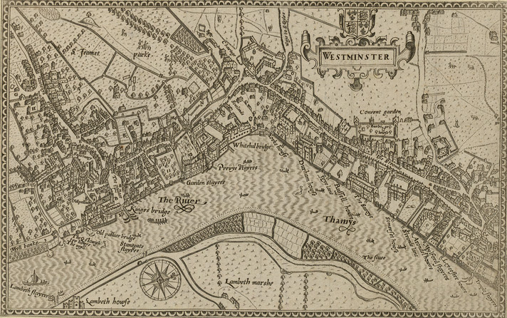
Norden's map of Westminster, surveyed and published 1593. From the Crace Collection at the British Library. The Strand, which is the main road on the right hand side of the map, was in its heyday as the favoured residence of the elite of the English aristocracy, and several of the major mansions located there are labelled on the map.
| תיאור | Norden's map of Westminster. | ||||
| תאריך יצירה | |||||
| מקור | Crace Collection at the British Library. | ||||
| יוצר | Norden | ||||
| אישורים והיתרים (שימוש חוזר בקובץ זה) |
|
||||
היסטוריית הקובץ
ניתן ללחוץ על תאריך/שעה כדי לראות את הקובץ כפי שנראה באותו זמן.
| תאריך/שעה | תמונה ממוזערת | ממדים | משתמש | הערה | |
|---|---|---|---|---|---|
| נוכחית | 19:10, 16 בפברואר 2006 | | 446 × 712 (193 ק"ב) | Merchbow~commonswiki (שיחה | תרומות) | Norden's map of Westminster, surveyed and published 1593. From the Crace Collection at the British Library. Category:Maps of London category:City of Westminster |
אין באפשרותך לדרוס את הקובץ הזה.
שימוש בקובץ
אין דפים המשתמשים בקובץ זה.
שימוש גלובלי בקובץ
אתרי הוויקי השונים הבאים משתמשים בקובץ זה:
- שימוש באתר de.wikipedia.org
- שימוש באתר en.wikipedia.org
- שימוש באתר es.wikipedia.org
- שימוש באתר he.wikipedia.org
- שימוש באתר ja.wikipedia.org
- שימוש באתר nrm.wikipedia.org
- שימוש באתר sco.wikipedia.org
- שימוש באתר zh.wikipedia.org
.jpg&oldid=868608261)