File:1799 Clement Crutwell Map of Hindoostan - Geographicus - India-cruttwell-1799.jpg
Naar navigatie springen
Naar zoeken springen

Grootte van deze voorvertoning: 505 × 600 pixels. Andere resoluties: 202 × 240 pixels | 404 × 480 pixels | 647 × 768 pixels | 862 × 1.024 pixels | 1.724 × 2.048 pixels | 2.947 × 3.500 pixels.
Oorspronkelijk bestand (2.947 × 3.500 pixels, bestandsgrootte: 2,51 MB, MIME-type: image/jpeg)
Bijschriften
Bijschriften
Beschrijf in één regel wat dit bestand voorstelt
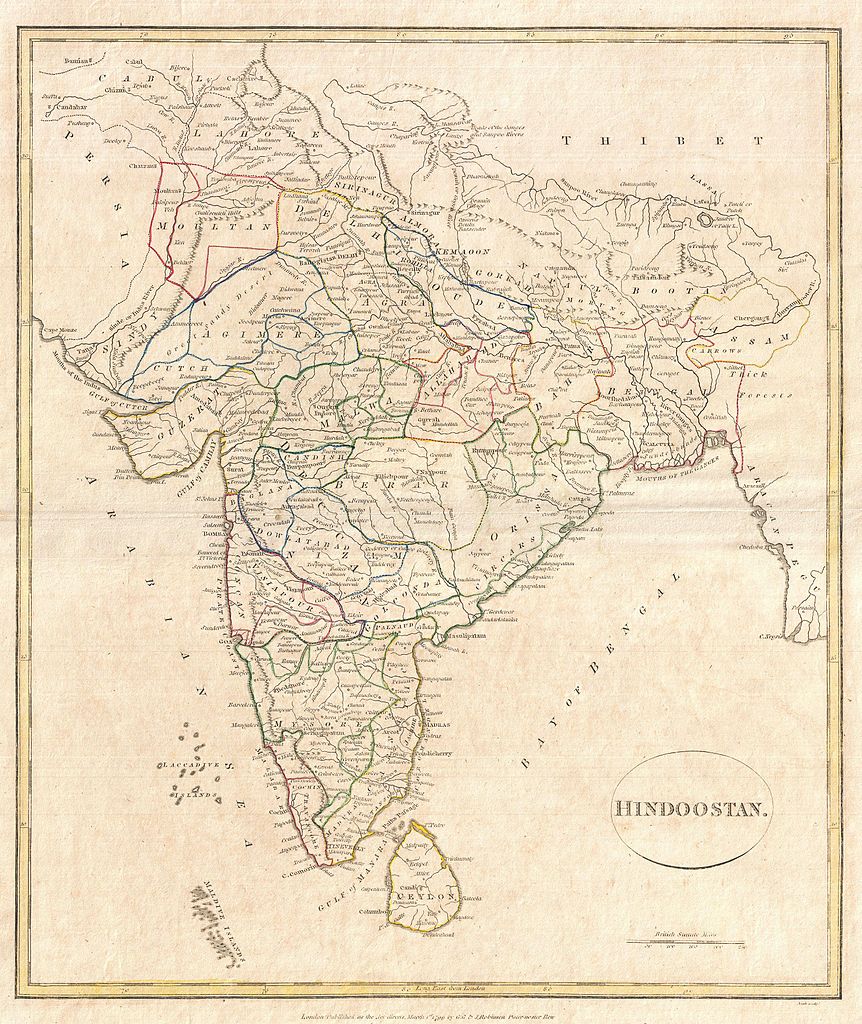
| Hindoostan. | ||||||
|---|---|---|---|---|---|---|
| Kunstenaar | ||||||
| Titel |
Hindoostan. |
|||||
| Beschrijving |
English: A fine 1799 map India, here labeled Hindoostan, by the English map publisher Clement Cruttwell. Covers the entire subcontinent and is divided into the various princely states. Though there is no specific reference to British dominance in the region, most of India had, at this juncture, fallen under the control of the British East India Company. Includes rivers, political boundaries, important cities, ports and gulfs. Mountains and other topographical features shown by profile. Outline color and fine copper plate engraving in the minimalist English style prevalent in the late 18th and early 19th centuries. Drawn by G. G. and J. Robinson of Paternoster Row, London, for Clement Cruttwell's 1799 Atlas to Cruttwell's Gazetteer. |
|||||
| Datum | 1799 (dated) | |||||
| Afmetingen | hoogte: 16 in (40,6 cm); breedte: 13,7 in (34,9 cm) | |||||
| Inventarisnummer |
Geographicus link: India-cruttwell-1799 |
|||||
| Bron/fotograaf |
Cruttwell, C., Atlas to Cruttwell's Gazetteer, 1799.
|
|||||
| Toestemming (Hergebruik van dit bestand) |
|
|||||
Bestandsgeschiedenis
Klik op een datum/tijd om het bestand te zien zoals het destijds was.
| Datum/tijd | Miniatuur | Afmetingen | Gebruiker | Opmerking | |
|---|---|---|---|---|---|
| huidige versie | 24 mrt 2011 11:45 | | 2.947 × 3.500 (2,51 MB) | BotMultichillT (overleg | bijdragen) | {{subst:User:Multichill/Geographicus |link=http://www.geographicus.com/P/AntiqueMap/India-cruttwell-1799 |product_name=1799 Clement Crutwell Map of Hindoostan |map_title=Hindoostan. |description=A fine 1799 map India, here labeled Hindoostan, by the Engli |
U kunt dit bestand niet overschrijven.
Bestandsgebruik
Dit bestand wordt op de volgende pagina gebruikt:
Globaal bestandsgebruik
De volgende andere wiki's gebruiken dit bestand:
- Gebruikt op nl.wiktionary.org