File:AGHRC (1890) - Carta IV - Virreinato de Santafé y Capitanía General de Venezuela.jpg
קפיצה לניווט
קפיצה לחיפוש
גודל התצוגה המקדימה הזאת: 743 × 600 פיקסלים. רזולוציות אחרות: 298 × 240 פיקסלים | 595 × 480 פיקסלים | 952 × 768 פיקסלים | 1,269 × 1,024 פיקסלים | 2,538 × 2,048 פיקסלים | 4,310 × 3,478 פיקסלים.
לקובץ המקורי (4,310 × 3,478 פיקסלים, גודל הקובץ: 5.73 מ"ב, סוג MIME: image/jpeg)
כיתובים
כיתובים
נא להוסיף משפט שמסביר מה הקובץ מייצג
תקציר[עריכה]
| תיאור |
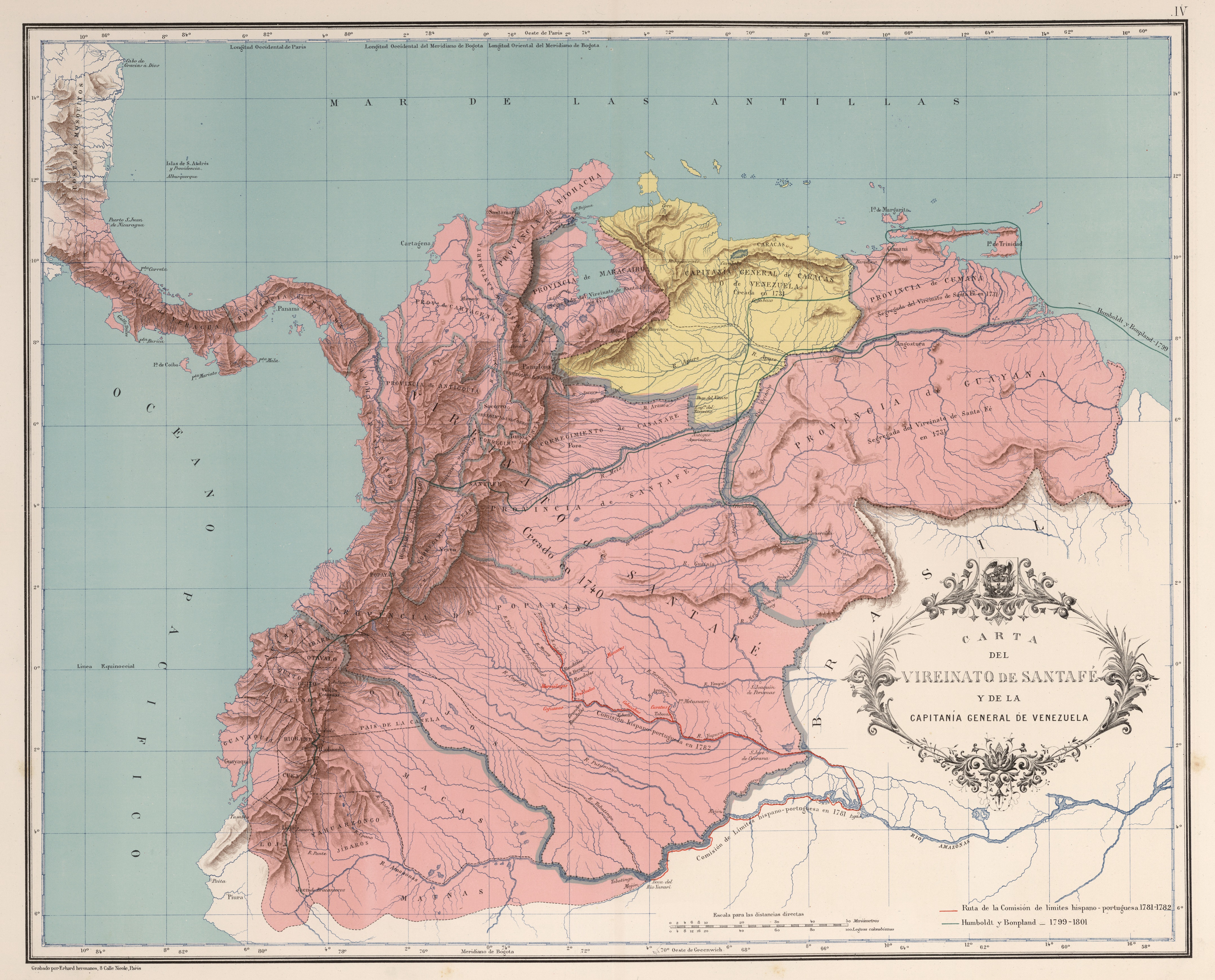
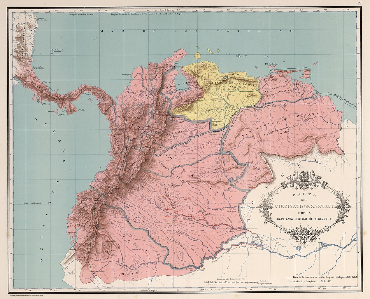
Español: Carta del Virreinato de Santafé y la Capitanía General de Venezuela (1742). Carta IV del Atlas geográfico e histórico de la República de Colombia, 1890. |
||||||||||||||||||||
| תאריך יצירה | |||||||||||||||||||||
| מקור | Atlas geográfico e histórico de la República de Colombia, 1890. | ||||||||||||||||||||
| יוצר |
|
||||||||||||||||||||

_-_Carta_III_-_Presidencias_de_Santaf%C3%A9_y_Quito.jpg)
_-_Carta_V_-_Divisi%C3%B3n_pol%C3%ADtica_del_Virreinato_de_Santaf%C3%A9,_1810.jpg)
_-_Carta_IV_-_Virreinato_de_Santaf%C3%A9_y_Capitan%C3%ADa_General_de_Venezuela.jpg&action=edit§ion=1)
רישיון[עריכה]
_-_Carta_IV_-_Virreinato_de_Santaf%C3%A9_y_Capitan%C3%ADa_General_de_Venezuela.jpg&action=edit§ion=2)
This file is in the public domain because the copyright of this work, registered in Colombia, has expired, according to “Law 23 of 1982 on Copyright, Articles 11, 21-29”, amended by “Law 44 of 1993, Article 2” and “Law 1520 of 2012, Articles 4, 6 and 10” (details). However, some restrictions have to be addressed:
|

|
היסטוריית הקובץ
ניתן ללחוץ על תאריך/שעה כדי לראות את הקובץ כפי שנראה באותו זמן.
| תאריך/שעה | תמונה ממוזערת | ממדים | משתמש | הערה | |
|---|---|---|---|---|---|
| נוכחית | 13:34, 28 בנובמבר 2018 | | 3,478 × 4,310 (5.73 מ"ב) | Milenioscuro (שיחה | תרומות) | high quality (from David Rumsey) |
| 04:26, 20 במרץ 2009 |  | 2,344 × 2,861 (2.97 מ"ב) | Milenioscuro (שיחה | תרומות) | {{Information |Description={{es|1=Carta del Virreinato de Santafé y la Capitanía General de Venezuela. Tomado del "Atlas geográfico e histórico de la República de Colombia", 1890.}} |Source=Atlas geográfico e histórico de la República de Colombia, |
אין באפשרותך לדרוס את הקובץ הזה.
שימוש בקובץ
הדפים הבאים משתמשים בקובץ הזה:
- Atlas Geográfico e Histórico de la República de Colombia (1890)
- Atlas of Colombia
- File:Atlas Geográfico e Histórico de la República de Colombia (1890) - Carta IV - Virreinato de Santafé y Capitanía General de Venezuela.jpg (הפניה של קובץ)
- File:Virreinato de Santafé y Capitanía General de Venezuela.jpg (הפניה של קובץ)
_-_Carta_IV_-_Virreinato_de_Santaf%C3%A9_y_Capitan%C3%ADa_General_de_Venezuela.jpg&redirect=no)
שימוש גלובלי בקובץ
אתרי הוויקי השונים הבאים משתמשים בקובץ זה:
- שימוש באתר ast.wikipedia.org
- שימוש באתר ca.wikipedia.org
- שימוש באתר cs.wikipedia.org
- שימוש באתר de.wikipedia.org
- שימוש באתר en.wikipedia.org
- שימוש באתר es.wikipedia.org
- Virreinato de Nueva Granada
- Compañía Guipuzcoana
- Capitanía general de Venezuela
- Batalla de Bocachica
- Época de la colonia (Venezuela)
- Provincia de Venezuela
- Organización territorial del Virreinato de Nueva Granada
- Historia política de Colombia
- Conflicto limítrofe entre el Perú y Colombia
- Protocolo Pedemonte-Mosquera
- שימוש באתר eu.wikipedia.org
- שימוש באתר fr.wikipedia.org
- שימוש באתר gl.wikipedia.org
- שימוש באתר he.wikipedia.org
- שימוש באתר it.wikipedia.org
- שימוש באתר pt.wikipedia.org
- שימוש באתר ru.wikipedia.org
- שימוש באתר sh.wikipedia.org
- שימוש באתר sk.wikipedia.org
- שימוש באתר uk.wikipedia.org
_-_Carta_IV_-_Virreinato_de_Santafé_y_Capitanía_General_de_Venezuela.jpg&oldid=790612243)