File:AMH-7679-NA Floor plan of Fort St. Antonie at Axim.jpg

File originale (1 372 × 2 400 pixel, dimensione del file: 428 KB, tipo MIME: image/jpeg)
Didascalie
Didascalie
Dettagli
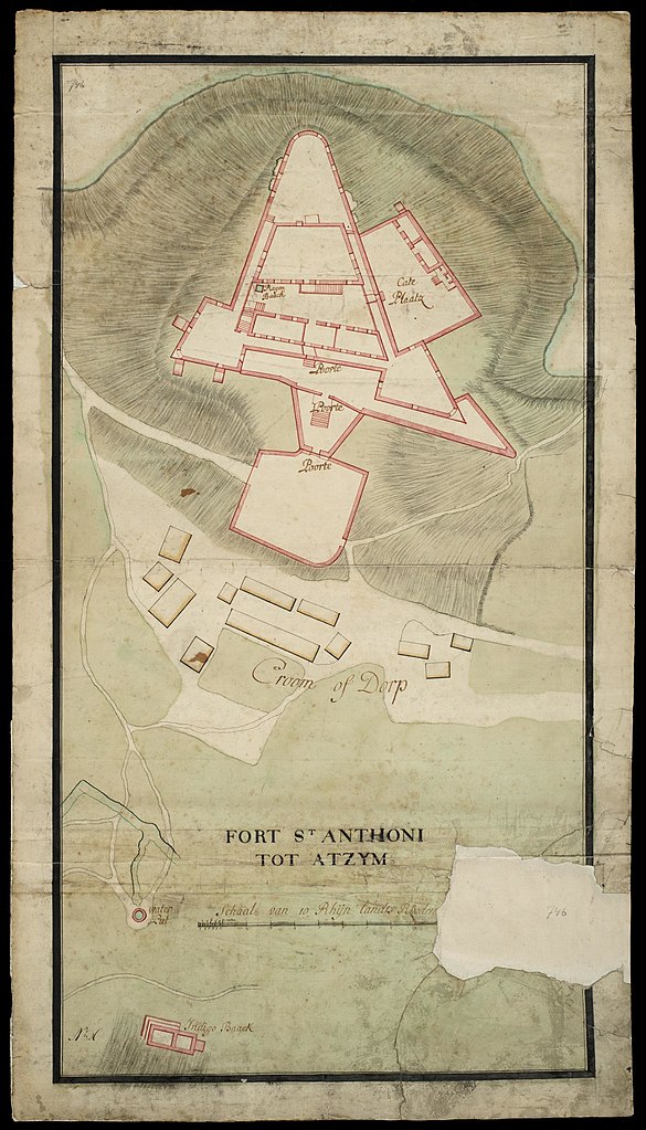
[modifica]Nederlands: Plattegrond van fort St. Antonie te Axim
English: Floor plan of Fort St. Antonie at Axim( |
||||||||||||||||||||||||
|---|---|---|---|---|---|---|---|---|---|---|---|---|---|---|---|---|---|---|---|---|---|---|---|---|
| Autore |
Nederlands: Anoniem / Anonymous (landmeter / kaartenmaker)
English: Anoniem / Anonymous (land surveyor / mapmaker) |
|||||||||||||||||||||||
| Titolo |
Nederlands: Plattegrond van fort St. Antonie te Axim
English: Floor plan of Fort St. Antonie at Axim |
|||||||||||||||||||||||
| Descrizione |
Nederlands: Plattegrond van fort St. Antonie te Axim.
Titel catalogus Leupe (NA): Platte grond van het fort St. Anthoni tot Atzym, benevens het Croom of dorp. Fort St Anthoni tot Atzym. Notities verso: No. 8 Fort St. Anthonij. Register 8, Deel 1, Folio 32, Portefeuille .. [geschreven op een blauw etiket] / 447 [met vette cijfers gestempeld op een etiketje].English: Floor plan of Fort St. Antonie at Axim.
Title in the Leupe catalogue (NA): Platte grond van het fort St. Anthoni tot Atzym, benevens het Croom of dorp. Fort St Anthoni tot Atzym. Notes on reverse: No. 8 Fort St. Anthonij. Register 8, Deel 1, Folio 32, Portefeuille .. [inscribed on a blue label] / 447 [stamped in bold figures on a small label]. |
|||||||||||||||||||||||
| Data | tra il 1700 e il 1750 | |||||||||||||||||||||||
| Tecnica/materiale |
Nederlands: ingekleurde tekening op papier
English: coloured drawing on paper |
|||||||||||||||||||||||
| Dimensioni | altezza: 48 cm; larghezza: 86 cm | |||||||||||||||||||||||
| Collezione |
|
|||||||||||||||||||||||
| Numero d'inventario |
NL-HaNA_4.VEL_746 (old number: VEL0746) |
|||||||||||||||||||||||
| Iscrizioni |
Fort St Anthoni tot Atzym
|
|||||||||||||||||||||||
| Note |
English: Subjects: fortification, building, chart / map / plan, tanck / well / watering hole
Nederlands: Onderwerpen: vesting, gebouw, plattegrond / kaart, tanck / waterplaats / put
English: Post: this image is related to a WIC trading post called Axim |
|||||||||||||||||||||||
| Fonte/Fotografo |
|
|||||||||||||||||||||||
| Licenza (Riusare questo file) |
|
|||||||||||||||||||||||

| Posizione del soggetto | | Posizione di questa e altre immagini su: OpenStreetMap |
|---|
Cronologia del file
Fare clic su un gruppo data/ora per vedere il file come si presentava nel momento indicato.
| Data/Ora | Miniatura | Dimensioni | Utente | Commento | |
|---|---|---|---|---|---|
| attuale | 10:06, 11 giu 2014 | | 1 372 × 2 400 (428 KB) | HuskyBot (discussione | contributi) | == {{int:filedesc}} == {{Artwork |title = {{nl|1=Plattegrond van fort St. Antonie te Axim}} {{en|1=Floor plan of Fort St. Antonie at Axim}} |description = {{nl|1=Plattegrond van fort St. Antonie te Axim. Titel... |
Impossibile sovrascrivere questo file.
Utilizzo del file
La seguente pagina usa questo file:
Utilizzo globale del file
Anche i seguenti wiki usano questo file:
- Usato nelle seguenti pagine di avk.wikipedia.org:
- Usato nelle seguenti pagine di en.wikipedia.org:
- Usato nelle seguenti pagine di ha.wikipedia.org:
- Usato nelle seguenti pagine di it.wikipedia.org: