File:Alamannien Hochburgund ca 1000.png
둘러보기로 이동
검색으로 이동
미리 보기 크기: 711 × 599 픽셀 다른 해상도: 285 × 240 픽셀 | 570 × 480 픽셀 | 911 × 768 픽셀 | 1,215 × 1,024 픽셀 | 2,500 × 2,107 픽셀
원본 파일 (2,500 × 2,107 픽셀, 파일 크기: 1.11 MB, MIME 종류: image/png)
캡션
설명
이 파일이 나타내는 바에 대한 한 줄 설명을 추가합니다
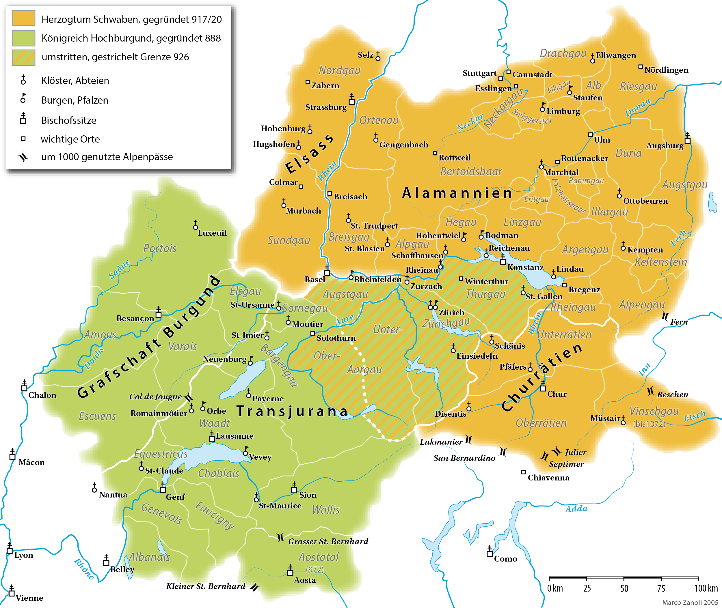
Map of the Duchy of Swabia and the Kingdom of Upper Burgundy in the 10th/11th century
파일 설명[편집]
| 설명 |
English: A map (in German) of the Duchy of Alamannia and the Kingdom of Upper Burgundy in the 10th century. |
| 날짜 | |
| 출처 | own work; G. Droysen: Allgemeiner Historischer Handatlas. Bielefeld / Leipzig, 1886, 22f. |
| 저자 | Marco Zanoli |
| 다른 버전 |
|


|
이 그림 파일은 벡터 SVG 형식으로 다시 만들어야 합니다. SVG의 장점에 대해서는 여기(영어)를 참고해 주십시오. 만약 이 그림의 SVG 버전이 이미 존재한다면 이 틀을 {{vector version available|새 파일 이름.svg}}으로 대체해 주십시오.
|
라이선스[편집]
You may use my work outside wikipedia for free as long as you name me as the author. If you would like to use my work in a print medium, please send me a specimen copy.
Contact me if you have questions regarding the license or if you want individual changes to the map (marco.zanoli at hotmail.ch). 이 파일은 크리에이티브 커먼즈 저작자표시-동일조건변경허락 4.0 국제 라이선스로 배포됩니다. 저작자표시: Marco Zanoli
|
파일 역사
날짜/시간 링크를 클릭하면 해당 시간의 파일을 볼 수 있습니다.
| 날짜/시간 | 섬네일 | 크기 | 사용자 | 설명 | |
|---|---|---|---|---|---|
| 현재 | 2021년 4월 10일 (토) 16:49 | | 2,500 × 2,107 (1.11 MB) | Sidonius (토론 | 기여) | Lukmanier und San Bernardino vertauscht |
| 2021년 3월 28일 (일) 14:11 |  | 2,500 × 2,107 (1.12 MB) | Sidonius (토론 | 기여) | kleinere Korrekturen, Gaue auch in Hochburgund in modernen Namen | |
| 2020년 11월 15일 (일) 18:49 |  | 1,500 × 1,319 (550 KB) | FootKalos1597 (토론 | 기여) | Added informations | |
| 2019년 2월 19일 (화) 08:08 |  | 1,500 × 1,319 (534 KB) | Sidonius (토론 | 기여) | - Chiavenna entfernt, da erst 1157 zu Schwaben | |
| 2019년 2월 18일 (월) 16:15 |  | 1,500 × 1,319 (535 KB) | Sidonius (토론 | 기여) | - Kloster St-Claude eingezeichnet - Beschriftung weiss hinterlegt - Vinschgau übereinstimmend mit Forschung zu Churrätien als Teil des Hzm. Schwaben eingezeichnet | |
| 2019년 1월 20일 (일) 13:24 |  | 1,500 × 1,319 (414 KB) | Sidonius (토론 | 기여) | - Abtei Hugshofen eingezeichnet - Aostatal als Teil von Hochburgund | |
| 2019년 1월 13일 (일) 14:22 |  | 1,500 × 1,285 (404 KB) | Sidonius (토론 | 기여) | weitere Fehler korrigiert, zusätzliche Orte eingezeichnet, Legende überarbeitet, Grenzen korrigiert gemäss Historischem Lexikon der CH | |
| 2019년 1월 12일 (토) 15:36 |  | 1,500 × 1,288 (392 KB) | Sidonius (토론 | 기여) | kleinere Fehler behoben in Beschriftungen, Farben noch etwas angepasst | |
| 2012년 11월 26일 (월) 23:10 |  | 1,500 × 1,322 (252 KB) | Hawky.diddiz (토론 | 기여) | Lossless optimization | |
| 2011년 5월 23일 (월) 11:54 |  | 1,500 × 1,322 (433 KB) | Sidonius (토론 | 기여) | letzter Versuch, die korrigierte Datei einzubinden |
이 파일을 덮어쓸 수 없습니다.
이 파일을 사용하는 문서
다음 문서 15개가 이 파일을 사용하고 있습니다:
- Atlas of Switzerland
- Maps of Switzerland
- User:J budissin/Uploads/BiH/2019 February 10-18
- User:J budissin/Uploads/BiH/2019 February 19-28
- User:J budissin/Uploads/BiH/2019 January 11-20
- User:Magog the Ogre/Multilingual legend/2020 November 11-20
- User:Magog the Ogre/Multilingual legend/2021 April 1-10
- User:Magog the Ogre/Multilingual legend/2021 March 21-31
- User:Sidonius
- User:Zinneke/Nei Biller iwwer Lëtzebuerg/2020 November 11-20
- File:Souabe et Haute-Bourgogne.png
- File:Souabe et Haute-Bourgogne.svg
- File:Souabe et Haute-Bourgogne1.png
- File talk:Heiliges Römisches Reich 1000.PNG
- Category:Duchy of Swabia
이 파일을 사용하고 있는 모든 위키의 문서 목록
다음 위키에서 이 파일을 사용하고 있습니다:
- als.wikipedia.org에서 이 파일을 사용하고 있는 문서 목록
- an.wikipedia.org에서 이 파일을 사용하고 있는 문서 목록
- ar.wikipedia.org에서 이 파일을 사용하고 있는 문서 목록
- arz.wikipedia.org에서 이 파일을 사용하고 있는 문서 목록
- ast.wikipedia.org에서 이 파일을 사용하고 있는 문서 목록
- bg.wikipedia.org에서 이 파일을 사용하고 있는 문서 목록
- br.wikipedia.org에서 이 파일을 사용하고 있는 문서 목록
- ca.wikipedia.org에서 이 파일을 사용하고 있는 문서 목록
- cs.wikipedia.org에서 이 파일을 사용하고 있는 문서 목록
- cy.wikipedia.org에서 이 파일을 사용하고 있는 문서 목록
- de.wikipedia.org에서 이 파일을 사용하고 있는 문서 목록
이 파일의 더 많은 사용 내역을 봅니다.