File:Armenia map numbered.svg
跳转到导航
跳转到搜索

此SVG文件的PNG预览的大小:587 × 599像素。 其他分辨率:235 × 240像素 | 470 × 480像素 | 752 × 768像素 | 1,003 × 1,024像素 | 2,006 × 2,048像素 | 725 × 740像素。
原始文件 (SVG文件,尺寸为725 × 740像素,文件大小:86 KB)
说明
说明
添加一行文字以描述该文件所表现的内容
摘要
[编辑]
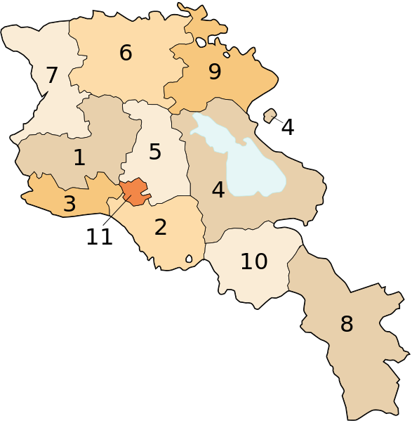
Image shows the eleven administrative subdivisions of Armenia:
- Aragatsotn (Արագածոտնի)
- Ararat (Արարատի)
- Armavir (Արմավիրի)
- Gegharkunik (Գեղարքունիքի)
- Kotayk (Կոտայքի)
- Lori (Լոռու)
- Shirak (Շիրակի)
- Syunik (Սյունիքի)
- Tavush (Տավուշի)
- Vayots Dzor (Վայոց Ձորի)
- Yerevan (Երևան) - special administrative status
Derived from a multiple of public sources and created using Inkscape.
许可协议
[编辑]

|
已授权您依据自由软件基金会发行的无固定段落及封面封底文字(Invariant Sections, Front-Cover Texts, and Back-Cover Texts)的GNU自由文件许可协议1.2版或任意后续版本的条款,复制、传播和/或修改本文件。该协议的副本请见“GNU Free Documentation License”。 |
| 本文件采用知识共享署名-相同方式共享 3.0 未本地化版本许可协议授权。 | ||
| ||
| 本许可协议标签作为GFDL许可协议更新的组成部分被添加至本文件。 |
文件历史
点击某个日期/时间查看对应时刻的文件。
| 日期/时间 | 缩略图 | 大小 | 用户 | 备注 | |
|---|---|---|---|---|---|
| 当前 | 2013年10月13日 (日) 17:18 | | 725 × 740(86 KB) | Fry1989(留言 | 贡献) | Per AN, this type of POV is improper and unacceptable |
| 2013年10月11日 (五) 20:06 |  | 725 × 740(80 KB) | Ankax Hayastan(留言 | 贡献) | Reverted to version as of 17:27, 26 September 2010 | |
| 2013年10月11日 (五) 20:00 |  | 725 × 740(86 KB) | Fry1989(留言 | 贡献) | Revert political POV | |
| 2010年9月26日 (日) 17:27 |  | 725 × 740(80 KB) | Ankax Hayastan(留言 | 贡献) | Reverted to version as of 17:31, 25 November 2006 (((Exclaves deleted according to official map at http://www.gov.am/en/regions/))) | |
| 2006年11月25日 (六) 19:37 |  | 725 × 740(86 KB) | Bastique(留言 | 贡献) | Cleanup | |
| 2006年11月25日 (六) 19:26 |  | 725 × 740(84 KB) | Bastique(留言 | 贡献) | Enclaves | |
| 2006年11月25日 (六) 17:31 |  | 725 × 740(80 KB) | Bastique(留言 | 贡献) | Fixed canvas size | |
| 2006年11月25日 (六) 17:27 |  | 744 × 1,052(78 KB) | Bastique(留言 | 贡献) | Image shows the subdivisions of Armenia. Derived from a multiple of public sources and created using Inkscape. == Licensing == {{GFDL}} Image shows the eleven administrative subdivisions of Armenia: #Aragatsotn (Արագածոտնի) #[[Ararat (pr |
您不可以覆盖此文件。
文件用途
以下12个页面使用本文件:
全域文件用途
以下其他wiki使用此文件:
- ast.wikipedia.org上的用途
- avk.wikipedia.org上的用途
- awa.wikipedia.org上的用途
- az.wikipedia.org上的用途
- az.wiktionary.org上的用途
- be-tarask.wikipedia.org上的用途
- be.wikipedia.org上的用途
- bg.wikipedia.org上的用途
- bn.wikipedia.org上的用途
- bs.wikipedia.org上的用途
- ca.wikipedia.org上的用途
- cs.wikipedia.org上的用途
- cy.wikipedia.org上的用途
- el.wikipedia.org上的用途
- en.wikipedia.org上的用途
- eo.wikipedia.org上的用途
- es.wikipedia.org上的用途
- fa.wikipedia.org上的用途
- fr.wikipedia.org上的用途
- hi.wikipedia.org上的用途
查看此文件的更多全域用途。