File:Asia Minor in the Greco-Roman period - general map - regions and main settlements.jpg
Jump to navigation
Jump to search
Size of this preview: 800 × 522 pixels. Other resolutions: 320 × 209 pixels | 640 × 418 pixels | 1,024 × 669 pixels | 1,280 × 836 pixels | 2,560 × 1,672 pixels | 6,167 × 4,027 pixels.
Original file (6,167 × 4,027 pixels, file size: 8.56 MB, MIME type: image/jpeg)
Captions
Captions
Add a one-line explanation of what this file represents
Summary[edit]
| Description |
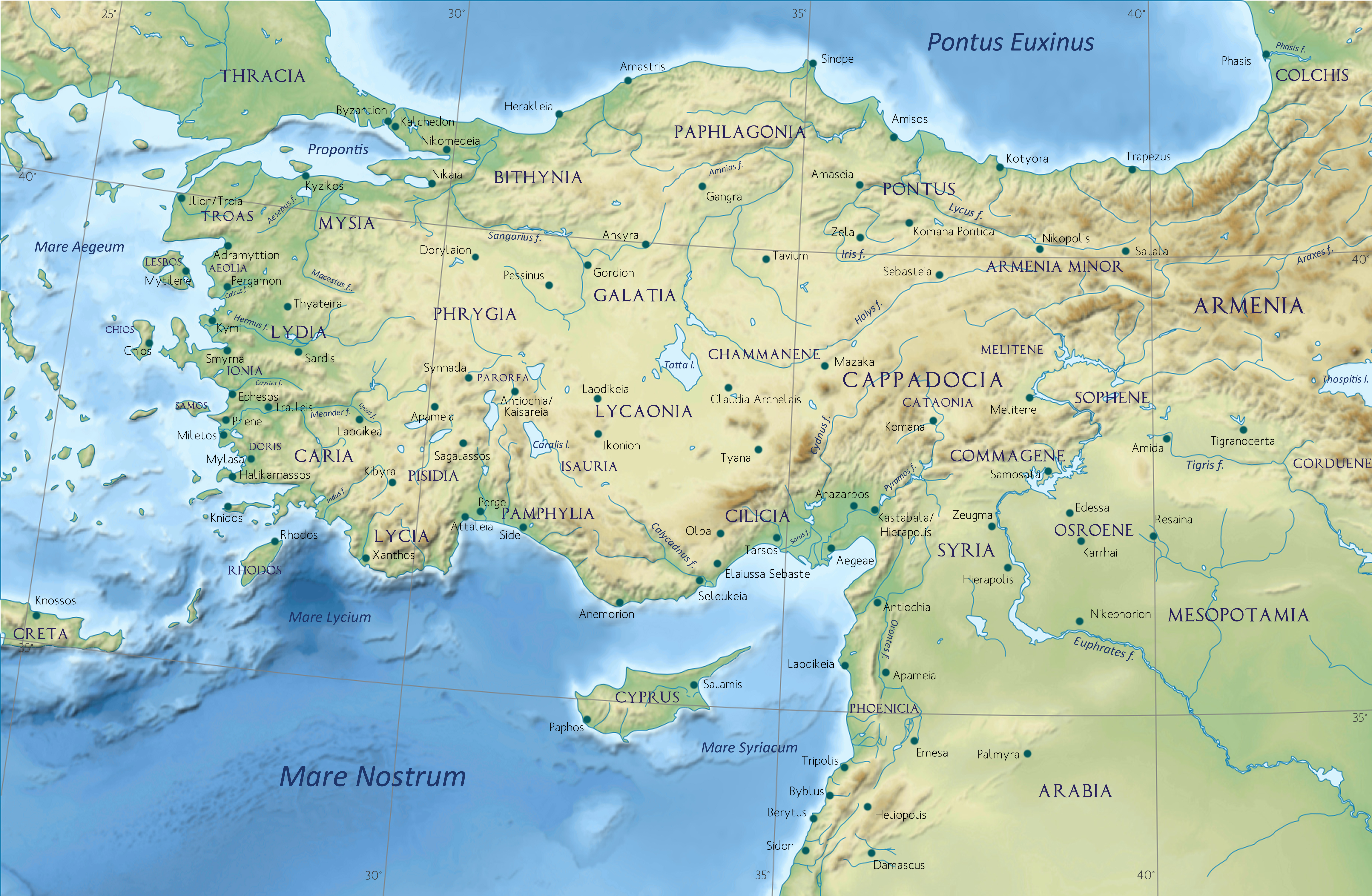
English: Asia Minor in the Greco-Roman period (332 BC - 395 AD) - general map - regions and main settlements |
| Date | (UTC) |
| Source | Own work |
| Author | Caliniuc since Putzger & Westermann atlases (Atlas zur Weltgeschichte, Stier, H.E., dir., 1985) |
| Permission (Reusing this file) |
Background since File:Turkey relief location map.jpg, NGDC ETOPO1, NASA Shuttle Radar Topography Mission SWBD, and World Data Bank II (public domain) |
| Other versions |
|
.jpg)
Licensing[edit]
I, the copyright holder of this work, hereby publish it under the following license:
This file is licensed under the Creative Commons Attribution-Share Alike 4.0 International license.
- You are free:
- to share – to copy, distribute and transmit the work
- to remix – to adapt the work
- Under the following conditions:
- attribution – You must give appropriate credit, provide a link to the license, and indicate if changes were made. You may do so in any reasonable manner, but not in any way that suggests the licensor endorses you or your use.
- share alike – If you remix, transform, or build upon the material, you must distribute your contributions under the same or compatible license as the original.
File history
Click on a date/time to view the file as it appeared at that time.
| Date/Time | Thumbnail | Dimensions | User | Comment | |
|---|---|---|---|---|---|
| current | 18:14, 28 April 2017 | | 6,167 × 4,027 (8.56 MB) | Caliniuc (talk | contribs) | User created page with UploadWizard |
You cannot overwrite this file.
File usage on Commons
The following 3 pages use this file:
File usage on other wikis
The following other wikis use this file:
- Usage on af.wikipedia.org
- Usage on ar.wikipedia.org
- Usage on arz.wikipedia.org
- Usage on ast.wikipedia.org
- Usage on ba.wikipedia.org
- Usage on ca.wikipedia.org
- Usage on de.wikipedia.org
- Usage on el.wikipedia.org
- Usage on en.wikipedia.org
- Galatia
- Bithynia
- Pontus (region)
- Cappadocia
- Pamphylia
- Mysia
- Isauria
- Paphlagonia
- Troad
- List of ancient Celtic peoples and tribes
- Phrygians
- Pisidia
- Lycaonia
- Cataonia
- Anatolian peoples
- Publius Servilius Vatia Isauricus
- Ancient regions of Anatolia
- Orontes I
- Asiatic style
- List of ancient peoples of Anatolia
- Syennesis (5th century)
- List of ancient Anatolian peoples
- Cinna (Galatia)
- User:Falcaorib
- History of Cilicia
- Caesarea (Mazaca)
- Gothic Revolt of Tribigild
- Usage on eo.wikipedia.org
- Usage on es.wikipedia.org
- Usage on et.wikipedia.org
- Usage on fa.wikipedia.org
- Usage on fr.wikipedia.org
View more global usage of this file.