File:Astrahanin sotaretki, kartta.png
Jump to navigation
Jump to search

Size of this preview: 800 × 597 pixels. Other resolutions: 320 × 239 pixels | 640 × 477 pixels | 1,024 × 764 pixels | 1,110 × 828 pixels.
Original file (1,110 × 828 pixels, file size: 722 KB, MIME type: image/png)
Captions
Captions
Add a one-line explanation of what this file represents
Summary
[edit]
| Description |
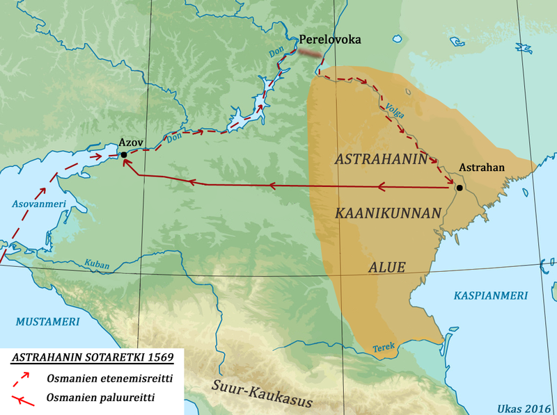
English: A map of Ottoman Astrakhan campaign of 1569 in Finnish language.
Suomi: Kartta Venäjän-Turkin sodan 1568-1570 ajan turkkilaisten Astrahanin sotaretkestä. |
| Date | |
| Source | Own work, information about routes based on descriptions in works by A. N. Kurat, Jerdjez Taranowski, etc. |
| Author | Ukas |
In Northern Caucasus region. Derivative work of Relief Map of Southern Federal District.jpg by User:Hellerick.
Licensing
[edit]
I, the copyright holder of this work, hereby publish it under the following license:
This file is licensed under the Creative Commons Attribution-Share Alike 4.0 International license.
- You are free:
- to share – to copy, distribute and transmit the work
- to remix – to adapt the work
- Under the following conditions:
- attribution – You must give appropriate credit, provide a link to the license, and indicate if changes were made. You may do so in any reasonable manner, but not in any way that suggests the licensor endorses you or your use.
- share alike – If you remix, transform, or build upon the material, you must distribute your contributions under the same or compatible license as the original.
File history
Click on a date/time to view the file as it appeared at that time.
| Date/Time | Thumbnail | Dimensions | User | Comment | |
|---|---|---|---|---|---|
| current | 08:34, 16 June 2016 | | 1,110 × 828 (722 KB) | Ukas (talk | contribs) | User created page with UploadWizard |
You cannot overwrite this file.
File usage on Commons
There are no pages that use this file.
File usage on other wikis
The following other wikis use this file:
- Usage on fi.wikipedia.org
- Usage on ka.wikipedia.org