File:Atmprofile.jpg
둘러보기로 이동
검색으로 이동
미리 보기 크기: 484 × 600 픽셀 다른 해상도: 194 × 240 픽셀 | 387 × 480 픽셀 | 670 × 830 픽셀
원본 파일 (670 × 830 픽셀, 파일 크기: 100 KB, MIME 종류: image/jpeg)
캡션
설명
이 파일이 나타내는 바에 대한 한 줄 설명을 추가합니다
파일 설명[편집]
| 설명 |
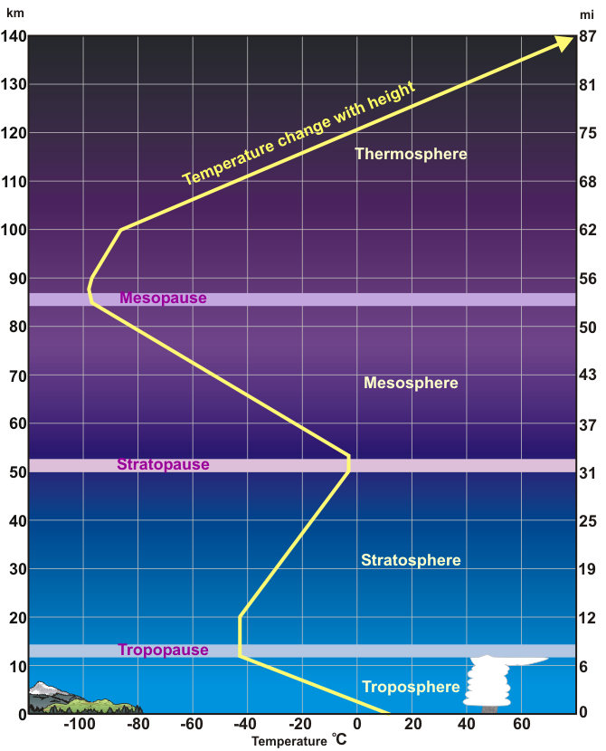
English: Standardized Temperature Profile
An average temperature profile through the lower layers of the atmosphere. Height (in miles and kilometers) is indicated along each side. Temperatures in the thermosphere continue to climb, reaching as high as (3,600°F) 2,000°C. |
| 날짜 | 날짜를 알 수 없음 |
| 출처 | http://www.srh.noaa.gov/srh/jetstream/atmos/atmprofile.htm |
| 저자 | 미상 |
| 다른 버전 |
|

라이선스[편집]
This image is in the public domain because it was stored on the web servers of the U.S. National Weather Service. NWS-created images are automatically public domain in the U.S. since the NWS is a part of the U.S. government. However, the NWS sites also host non-NWS images which have been submitted by individuals: these are generally shown as "Courtesy of ...". Such images have explicitly been released to the public domain by the copyright owner as part of the upload process.
As stated at https://www.weather.gov/fsd/disclaimer: "By submitting images, you understand that your image is being released into the public domain. This means that your photo or video may be downloaded, copied, and used by others." Thus, all* images on NWS servers are public domain (including "Courtesy of ..." and “Photo by ...” images) unless specifically stated otherwise through a copyright (©) watermark.
*A deletion discussion in November 2023 ruled that Getty Images on the web servers of NWS, are to be considered copyrighted, even without a copyright (©) watermark and are the sole exception to this rule.
|
파일 역사
날짜/시간 링크를 클릭하면 해당 시간의 파일을 볼 수 있습니다.
| 날짜/시간 | 섬네일 | 크기 | 사용자 | 설명 | |
|---|---|---|---|---|---|
| 현재 | 2010년 12월 11일 (토) 12:36 | | 670 × 830 (100 KB) | P.wormer~commonswiki (토론 | 기여) | {{Information |Description={{en|1=Standardized Temperature Profile An average temperature profile through the lower layers of the atmosphere. Height (in miles and kilometers) is indicated along each side. Temperatures in the thermosphere continue to clim |
이 파일을 덮어쓸 수 없습니다.
이 파일을 사용하는 문서
이 파일을 사용하는 문서가 없습니다.
이 파일을 사용하고 있는 모든 위키의 문서 목록
다음 위키에서 이 파일을 사용하고 있습니다: