File:Atropatene as a vassal of Seleucids.png
Jump to navigation
Jump to search

Size of this preview: 800 × 582 pixels. Other resolutions: 320 × 233 pixels | 640 × 466 pixels | 1,038 × 755 pixels.
Original file (1,038 × 755 pixels, file size: 241 KB, MIME type: image/png)
Captions
Captions
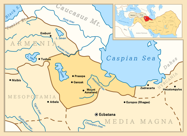
Map of Atropatene as a vassal of the Seleucid Empire
Summary[edit]
| Description |
English: Map depicting Atropatene in a close-up view, with territories surrounding it as well as a zoomed-out view, showing all of the empire and neighboring countries. |
| Date | |
| Source |
Own work. Borders adapted from:
This PNG graphic was created with Medibang. |
| Author | Golden |
Licensing[edit]
I, the copyright holder of this work, hereby publish it under the following license:
This file is licensed under the Creative Commons Attribution-Share Alike 4.0 International license.
- You are free:
- to share – to copy, distribute and transmit the work
- to remix – to adapt the work
- Under the following conditions:
- attribution – You must give appropriate credit, provide a link to the license, and indicate if changes were made. You may do so in any reasonable manner, but not in any way that suggests the licensor endorses you or your use.
- share alike – If you remix, transform, or build upon the material, you must distribute your contributions under the same or compatible license as the original.
File history
Click on a date/time to view the file as it appeared at that time.
| Date/Time | Thumbnail | Dimensions | User | Comment | |
|---|---|---|---|---|---|
| current | 11:34, 1 September 2020 | | 1,038 × 755 (241 KB) | Golden (talk | contribs) | Made the borders in the top-right map a bit thicker |
| 09:44, 28 August 2020 |  | 1,038 × 755 (240 KB) | Golden (talk | contribs) | Changed colour of Armenia and Cappadocia to a lighter colour in the top-right map as they were vassal states, not provinces of Seleucids | |
| 21:27, 27 August 2020 |  | 1,038 × 755 (239 KB) | Golden (talk | contribs) | Added "(Rhagae)" near Europos as it was also a common name for the city at the time | |
| 20:56, 27 August 2020 |  | 1,038 × 755 (237 KB) | Golden (talk | contribs) | Added 2 new cities: Europos and Arbela | |
| 15:25, 27 August 2020 |  | 1,038 × 755 (234 KB) | Golden (talk | contribs) | Fixed typo, Asnavad->Asnavand. Also expanded the smaller map on the top right to a bit right, so it the border isn't on the frame. | |
| 14:16, 27 August 2020 |  | 1,038 × 755 (234 KB) | Golden (talk | contribs) | Changed name of the city Takht-e Soleyman to Mount Asnavand as that is the name it was known by at those times | |
| 08:03, 27 August 2020 |  | 1,038 × 755 (234 KB) | Golden (talk | contribs) | Changed font of regions, mountains, seas. Deleted Tabriz, added 2 other cities in Atropatene. | |
| 00:32, 27 August 2020 |  | 1,038 × 755 (234 KB) | Golden (talk | contribs) | Uploaded own work with UploadWizard |
You cannot overwrite this file.
File usage on Commons
The following 3 pages use this file:
File usage on other wikis
The following other wikis use this file:
- Usage on ast.wikipedia.org
- Usage on az.wikipedia.org
- Usage on ba.wikipedia.org
- Usage on be.wikipedia.org
- Usage on bg.wikipedia.org
- Usage on ca.wikipedia.org
- Usage on cs.wikipedia.org
- Usage on el.wikipedia.org
- Usage on en.wikipedia.org
- Usage on es.wikipedia.org
- Usage on eu.wikipedia.org
- Usage on fa.wikipedia.org
- Usage on fi.wikipedia.org
- Usage on ko.wikipedia.org
- Usage on lt.wikipedia.org
- Usage on nl.wikipedia.org
- Usage on ro.wikipedia.org
- Usage on ru.wikipedia.org
- Usage on sr.wikipedia.org
- Usage on th.wikipedia.org
- Usage on tr.wikipedia.org
- Usage on uk.wikipedia.org
- Usage on ur.wikipedia.org
- Usage on www.wikidata.org