File:Babylonian Celestial Map.png
Jump to navigation
Jump to search
Size of this preview: 799 × 368 pixels. Other resolutions: 320 × 147 pixels | 640 × 295 pixels | 1,535 × 707 pixels.
Original file (1,535 × 707 pixels, file size: 909 KB, MIME type: image/png)
Captions
Captions
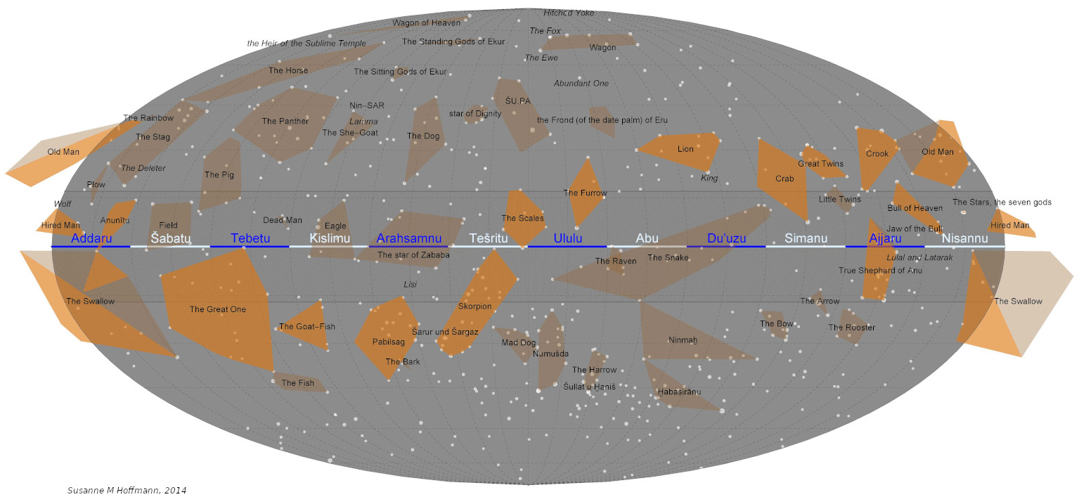
Map of the Babylonian uranology
Summary[edit]
| Description |
English: Map of the Babylonian Sky. Celestial equator divided in 12 equal parts (ideal months), constellations as polygons because only estimates of their position can be derived from the preserved data. Pingree's identification of constellations. Path of Anu marked in grey, path of the moon brighter than other constellations. Similar maps have been published in Hoffmann, Springer (2017). |
| Date | |
| Source | Own work |
| Author | Susanne M Hoffmann |
Licensing[edit]
I, the copyright holder of this work, hereby publish it under the following license:
This file is licensed under the Creative Commons Attribution-Share Alike 4.0 International license.
- You are free:
- to share – to copy, distribute and transmit the work
- to remix – to adapt the work
- Under the following conditions:
- attribution – You must give appropriate credit, provide a link to the license, and indicate if changes were made. You may do so in any reasonable manner, but not in any way that suggests the licensor endorses you or your use.
- share alike – If you remix, transform, or build upon the material, you must distribute your contributions under the same or compatible license as the original.
File history
Click on a date/time to view the file as it appeared at that time.
| Date/Time | Thumbnail | Dimensions | User | Comment | |
|---|---|---|---|---|---|
| current | 20:01, 23 August 2021 | | 1,535 × 707 (909 KB) | LittleAstronomer (talk | contribs) | Uploaded own work with UploadWizard |
You cannot overwrite this file.
File usage on Commons
There are no pages that use this file.
File usage on other wikis
The following other wikis use this file:
- Usage on ca.wikipedia.org
- Usage on de.wikibooks.org
- Usage on en.wikipedia.org