File:Baldcypress range.jpg
Pereiti į navigaciją
Jump to search
Šios peržiūros dydis: 457 × 600 taškų. Kitos 3 rezoliucijos: 183 × 240 taškų | 366 × 480 taškų | 640 × 840 taškų.
Pradinė rinkmena (640 × 840 taškų, rinkmenos dydis: 93 KiB, MIME tipas: image/jpeg)
Captions
Captions
Add a one-line explanation of what this file represents
Aprašymas[keisti]
| Aprašymas |
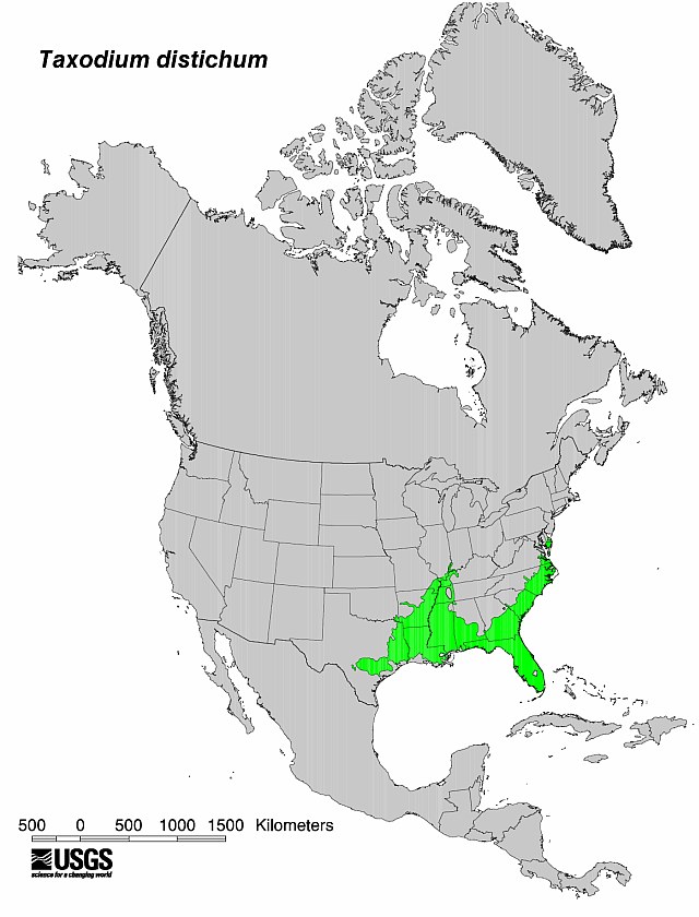
English: Flora distribution map Bald Cypress (Taxodium distichum) tree.
|
| Data | No clue when it was produced by the USGS - I'm uploading it here 5/25/09 |
| Šaltinis | USGS |
| Autorius | USGS |


Licencija[keisti]
This image is in the public domain in the United States because it only contains materials that originally came from the United States Geological Survey, an agency of the United States Department of the Interior. For more information, see the official USGS copyright policy.
|
Originalus įkėlimo įrašas[keisti]
Perkelta iš en.wikipedia į Vikiteką by Sreejithk2000 naudojant CommonsHelper.
Pirminis aprašymo puslapis buvo čia. Visi žemiau perteikti naudotojų vardai priklauso en.wikipedia.
- 2009-05-25 18:58 Nuberger13 640×840× (94968 bytes) {{Information |Description = Map showing the range of the baldcypress tree |Source = USGS |Date = No clue when it was produced by the USGS - I'm uploading it here 5/25/09 |Author = USGS |Permission = PD |other_versio
Rinkmenos istorija
Paspauskite ant datos/laiko, kad pamatytumėte rinkmeną tokią, kokia ji buvo tuo metu.
| Data/Laikas | Miniatiūra | Matmenys | Naudotojas | Paaiškinimas | |
|---|---|---|---|---|---|
| dabartinis | 07:47, 1 birželio 2010 | | 640 × 840 (93 KiB) | File Upload Bot (Magnus Manske) (aptarimas | indėlis) | {{BotMoveToCommons|en.wikipedia|year={{subst:CURRENTYEAR}}|month={{subst:CURRENTMONTHNAME}}|day={{subst:CURRENTDAY}}}} {{Information |Description={{en|Map showing the range of the baldcypress tree}} |Source=Transferred from [http://en.wikipedia.org en.wi |
Jūs negalite perrašyti šios rinkmenos.
Rinkmenos naudojimas
Šis puslapis naudoja šią rinkmeną:
Visuotinis rinkmenos naudojimas
Ši rinkmena naudojama šiose viki svetainėse:
- Naudojama ceb.wikipedia.org
- Naudojama en.wikipedia.org
- Naudojama eo.wikipedia.org
- Naudojama he.wikipedia.org
- Naudojama hu.wikipedia.org
- Naudojama is.wikipedia.org
- Naudojama lt.wikipedia.org
- Naudojama ru.wikipedia.org
- Naudojama war.wikipedia.org