File:Bananal-Island-North-End-Landsat-25-07-1992.png
Jump to navigation
Jump to search

Size of this preview: 600 × 600 pixels. Other resolutions: 240 × 240 pixels | 480 × 480 pixels | 768 × 768 pixels | 1,024 × 1,024 pixels.
Original file (1,024 × 1,024 pixels, file size: 610 KB, MIME type: image/png)
Captions
Captions
Add a one-line explanation of what this file represents
Summary[edit]
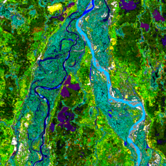
| Description | Landsat image of the northern end of Bananal Island, Brazil |
| Date | |
| Source | Landsat http://www.geog.ucsb.edu/~rivers/sa/bananal-web/cluster50.gif |
| Author | Landsat 5, US Government |
| Permission (Reusing this file) |
Public Domain |
Licensing[edit]
This image is in the public domain because it contains materials that originally came from the U.S. National Oceanic and Atmospheric Administration, taken or made as part of an employee's official duties.
|
Original upload log[edit]
| Date/Time | Dimensions | User | Comment |
|---|---|---|---|
| 15 August 2006, 21:25:13 | 1024 × 1024 (508177 bytes) | Bejnar (talk · contribs) | {{Information |Description=Landsat image of the northern end of Bananal Island |Source=Landsat http://www.geog.ucsb.edu/~rivers/sa/bananal-web/cluster50.gif |Date= 25 July 1992 |Author= Landsat 5, US Government |Permission=Public Domain |other_versions= } |
File history
Click on a date/time to view the file as it appeared at that time.
| Date/Time | Thumbnail | Dimensions | User | Comment | |
|---|---|---|---|---|---|
| current | 10:09, 23 August 2014 | | 1,024 × 1,024 (610 KB) | GifTagger (talk | contribs) | Bot: Converting file to superior PNG file. (Source: Bananal-Island-North-End-Landsat-25-07-1992.gif). This GIF was problematic due to non-greyscale color table. |
You cannot overwrite this file.
File usage on Commons
The following 2 pages use this file:
File usage on other wikis
The following other wikis use this file:
- Usage on af.wikipedia.org
- Usage on ca.wikipedia.org
- Usage on cs.wikipedia.org
- Usage on en.wikipedia.org
- Usage on eo.wikipedia.org
- Usage on es.wikipedia.org
- Usage on fa.wikipedia.org
- Usage on fi.wikipedia.org
- Usage on gl.wikipedia.org
- Usage on he.wikipedia.org
- Usage on id.wikipedia.org
- Usage on it.wikipedia.org
- Usage on ja.wikipedia.org
- Usage on ko.wikipedia.org
- Usage on nl.wikipedia.org
- Usage on pl.wikipedia.org
- Usage on pt.wikipedia.org
- Usage on ro.wikipedia.org
- Usage on sl.wikipedia.org
- Usage on sr.wikipedia.org
- Usage on vi.wikipedia.org
- Usage on war.wikipedia.org
- Usage on www.wikidata.org
- Usage on zh.wikipedia.org