File:Battle of Daraa City.svg
Vai alla navigazione
Vai alla ricerca

Dimensioni di questa anteprima PNG per questo file SVG: 600 × 600 pixel. Altre risoluzioni: 240 × 240 pixel | 480 × 480 pixel | 768 × 768 pixel | 1 024 × 1 024 pixel | 2 048 × 2 048 pixel | 1 500 × 1 500 pixel.
File originale (file in formato SVG, dimensioni nominali 1 500 × 1 500 pixel, dimensione del file: 2,8 MB)
Didascalie
Didascalie
Aggiungi una brevissima spiegazione di ciò che questo file rappresenta
Dettagli
[modifica]| Descrizione |
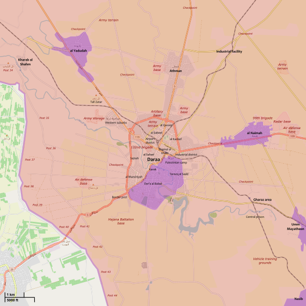
English: Map showing the current strategic situation in Daraa City.
العربية: .خريطة تظهر الحالة الإستراتيجية في مدينا درعا
Syrian Arab Republic full control
Reconciled rebels control (no Syrian Government presence)
Reconciled rebels control (with Syrian Government presence) |
||||
| Data | |||||
| Fonte | Opera propria | ||||
| Autore | MrPenguin20 | ||||
| Altre versioni |
|
||||
| SVG sviluppo | Questa mappa in grafica vettoriale è stata creata con Inkscape. |


.svg)


.svg)


.svg)


_Territory_Change_2014-2016.gif)

_(within_Northern_Syria).svg)


.png)
.svg)


_map.png)
.svg)


.svg)


Licenza
[modifica]
Io, detentore del copyright su quest'opera, dichiaro di pubblicarla con la seguente licenza:
Questo file è disponibile in base alla licenza Creative Commons Attribuzione-Condividi allo stesso modo 3.0 Unported
- Tu sei libero:
- di condividere – di copiare, distribuire e trasmettere quest'opera
- di modificare – di adattare l'opera
- Alle seguenti condizioni:
- attribuzione – Devi fornire i crediti appropriati, un collegamento alla licenza e indicare se sono state apportate modifiche. Puoi farlo in qualsiasi modo ragionevole, ma non in alcun modo che suggerisca che il licenziante approvi te o il tuo uso.
- condividi allo stesso modo – Se remixi, trasformi o sviluppi il materiale, devi distribuire i tuoi contributi in base alla stessa licenza o compatibile all'originale.
| This work contains information from OpenStreetMap, which is made available under the Open Database License (ODbL).
The ODbL does not require any particular license for maps produced from ODbL data. Prior to 1 August 2020, map tiles produced by the OpenStreetMap Foundation were licensed under the CC-BY-SA-2.0 license. Maps produced by other people may be subject to other licences. |
Cronologia del file
Fare clic su un gruppo data/ora per vedere il file come si presentava nel momento indicato.
| Data/Ora | Miniatura | Dimensioni | Utente | Commento | |
|---|---|---|---|---|---|
| attuale | 17:26, 19 set 2021 | | 1 500 × 1 500 (2,8 MB) | Rr016 (discussione | contributi) | Update. Syrian Army forced new agreement for Daraa Al-Balad (Sept. 5), Al-Yadudah (Sept. 13), Muzayrib (Sept. 16), and Tafas (Sept. 18)) |
| 13:13, 1 ago 2021 |  | 1 500 × 1 500 (2,81 MB) | Rr016 (discussione | contributi) | Overhauled map, made corrections | |
| 18:17, 12 lug 2018 |  | 711 × 628 (564 KB) | Rr016 (discussione | contributi) | Rebel forces in Daraa agree to reconcile; hostilities have ceased and the city is back under full SAA control... | |
| 19:59, 9 lug 2018 |  | 711 × 628 (567 KB) | Rr016 (discussione | contributi) | Big update: Daraa encircled | |
| 16:48, 6 lug 2018 |  | 711 × 628 (567 KB) | Rr016 (discussione | contributi) | Updates | |
| 20:22, 30 giu 2018 |  | 711 × 628 (575 KB) | Rr016 (discussione | contributi) | Let the map updates begin... | |
| 00:30, 21 apr 2017 |  | 711 × 628 (580 KB) | MrPenguin20 (discussione | contributi) | Wider surrounds of Daraa bit different atm (although I think the western/eastern frontlines are largely inactive) - e.g. see http://syria.liveuamap.com/. Updates on further advances in Daraa al-Manshiyah District by opposition groups - https://pbs.twim... | |
| 04:09, 3 mar 2017 |  | 711 × 628 (597 KB) | Kami888 (discussione | contributi) | based on https://pbs.twimg.com/media/C53GRnwWQAEX94B.jpg together with previously cited sources | |
| 14:07, 16 feb 2017 |  | 711 × 628 (578 KB) | Kami888 (discussione | contributi) | rebel offensive per multiple sources https://pbs.twimg.com/media/C4yN6ScWYAEtoBz.jpg https://pbs.twimg.com/media/C4x68O3XAAE6L2F.jpg https://pbs.twimg.com/media/C4o9mFTXAAAzavC.jpg https://archicivilians.files.wordpress.com/2017/02/daraa-feb14.jpg | |
| 14:49, 12 feb 2016 |  | 711 × 628 (571 KB) | MrPenguin20 (discussione | contributi) | Updates. |
Impossibile sovrascrivere questo file.
Utilizzo del file
Più di 100 pagine usano questo file. Di seguito sono elencate solo le prime 100 pagine che usano questo file. È disponibile un elenco completo.
- User:Faebot/SVG report 2014-04
- User:Hermes79
- User:Hermes7979
- User:Magog the Ogre/Maps of conflicts/2017 April
- User:Magog the Ogre/Maps of conflicts/2017 February
- User:Magog the Ogre/Maps of conflicts/2017 March
- User:Magog the Ogre/Maps of conflicts/2018 July
- User:Magog the Ogre/Maps of conflicts/2021 September
- User:MrPenguin21
- User talk:Rr016
- File:2013 Hama Offensive.svg
- File:2015 Latakia Frontlines.svg
- File:Aleppo Offensives 2015.svg
- File:Aleppo offensive (October 2013).svg
- File:Attaques-terroristes-meurtrières-au-21eme-siecle.png
- File:Battle of Daraa City.svg
- File:Battle of Hasakah.svg
- File:Battle of Qamishli.svg
- File:Battle of Raqqa.svg
- File:Battle of Tadmur.svg
- File:Battle of Western Qalamoun.svg
- File:Battlefields in The Global War on Terror.svg
- File:Battlefields in The Global War on Terror - edit03.png
- File:Battlefields in The Global War on Terror - edit04.png
- File:Benghazi Conflict Detailed Map.png
- File:Benghazi Conflict Detailed Map.svg
- File:Boko Haram insurgency map.svg
- File:Countries by soldier count.svg
- File:Daraa 2018 gif.gif
- File:Deir ez-Zor clashes (2017).svg
- File:Derna Conflict Detailed Map.png
- File:East Congo conflict map.svg
- File:GSPC map.png
- File:ISIS (Grey) Territory Change 2014-2016.gif
- File:Iraqi Civil War map (2014–present).png
- File:Iraqi–Kurdish conflict map.png
- File:Islamist insurgency in Nigeria.svg
- File:Lebanese insurgency.svg
- File:Libyan Civil War.svg
- File:Libyan war final-fr.svg
- File:Map of Ongoing conflicts around the world.png
- File:Map of terror of the Islamic State (ad-Daula al-islāmiyya).png
- File:Mexico states map small war.PNG
- File:Mosul offensive (2015) map.png
- File:Number of Terrorist Incidents.png
- File:Ongoing Conflicts (1).png
- File:Pakistan-Waziristan-Map.png
- File:Political map Afar triangle.png
- File:Rif Damashq.svg
- File:Siege of Homs Map.svg
- File:Sinai insurgency.svg
- File:Sinai map.PNG
- File:Somali Civil War (2009-present).svg
- File:Syria and Iraq 2014-onward War map.png
- File:Syrian, Iraqi, and Lebanese insurgencies.png
- File:Syrian Civil War map.svg
- File:Syrian civil war.png
- File:Tadmur offensive (2015).jpg
- File:Turkish attack on Efrin.svg
- File:Yemeni Civil War.svg
- Template:City maps of ongoing civil wars
- Category:Aleppo
- Category:Attack
- Category:Battle of Aleppo
- Category:Battles in 2016
- Category:Battles in 2022
- Category:Battles of Syria
- Category:Battles of the Syrian Civil War
- Category:Cities in Syria
- Category:Civil wars
- Category:Conflicts
- Category:Conflicts by continent
- Category:Conflicts by country
- Category:Conflicts by type
- Category:Feuds
- Category:Fights
- Category:Liberation of Palmyra (2016)
- Category:Maps of Aleppo
- Category:Maps of Somali Civil War
- Category:Maps of conflicts
- Category:Maps of disputed territories
- Category:Maps of the Syrian Civil War in 2016
- Category:Maps of the Syrian Civil War in 2017
- Category:Maps of the Syrian Civil War in 2018
- Category:Maps of the Syrian Civil War in 2019
- Category:Maps of the Syrian Civil War in 2020
- Category:Maps of the Syrian Civil War in 2021
- Category:Maps of the Syrian Civil War in 2022
- Category:Military conflicts
- Category:Ongoing armed conflicts
- Category:Palmyra offensive (December 2016)
- Category:Quarrels
- Category:Rebellions
- Category:Riots
- Category:Schisms
- Category:Syrian Civil War
- Category:Terrorism
- Category:Uprisings
- Category:War casualties
- Category:Warfare by type
.svg)
.png)
.png)
.png)
.jpg)
Visualizza altri collegamenti a questo file.
Utilizzo globale del file
Anche i seguenti wiki usano questo file:
- Usato nelle seguenti pagine di ar.wikipedia.org:
- Usato nelle seguenti pagine di en.wikipedia.org:
- Usato nelle seguenti pagine di fo.wikipedia.org:
- Usato nelle seguenti pagine di id.wikipedia.org:
- Usato nelle seguenti pagine di ku.wikipedia.org:
- Usato nelle seguenti pagine di pa.wikipedia.org:
- Usato nelle seguenti pagine di pl.wikipedia.org:
- Usato nelle seguenti pagine di tr.wikipedia.org:
- Usato nelle seguenti pagine di www.wikidata.org:
- Usato nelle seguenti pagine di zh.wikipedia.org: