File:Bay-of-Piran maritime-boundary-dispute.jpg
Vai alla navigazione
Vai alla ricerca
Non sono disponibili versioni a risoluzione più elevata.
Bay-of-Piran_maritime-boundary-dispute.jpg (709 × 600 pixel, dimensione del file: 160 KB, tipo MIME: image/jpeg)
Didascalie
Didascalie
Aggiungi una brevissima spiegazione di ciò che questo file rappresenta
Dettagli
[modifica]
|
File:Bay-of-Piran maritime-boundary-dispute.svg è una versione vettoriale di questo file. Dovrebbe essere usata quella versione al posto di questo file JPG, quando sia migliore.
File:Bay-of-Piran maritime-boundary-dispute.jpg → File:Bay-of-Piran maritime-boundary-dispute.svg
Per maggiori informazioni, vedi Help:SVG. |
 |
| Descrizione |
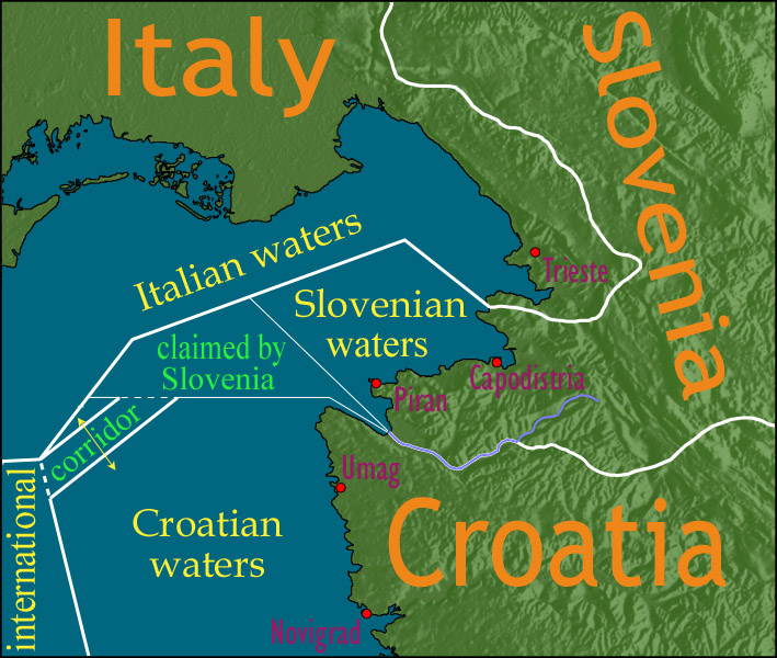
English: Map showing a diplomatic dispute resulting from Slovenia's desire to obtain a direct corridor from its own territorial waters to international waters, to avoid the necessity of Slovenian ships having to sail through the territorial waters of any other country to get to the high seas. Slovenia's only seacoast is in the Bay of Piran / Gulf of Trieste (as shown in this map), and its only commercial seaport is Capodistria / Koper (the eastern of the two red dots in Slovenia on this map), while Italy and Croatia both have long seacoasts outside the area shown in this map.
Slovenia's claim to the area labelled with green text, and the existence of a corridor to international waters, would have been allowed by Croatia under the Drnovšek-Račan agreement, but this was never ratified by either countries' parliaments. This is an English version of image de:Bild:Grenzstreit-Bucht-von-Piran.jpg, created using image Image:BorderDispute_BayOfPiran_blank.png. Raw Adobe Photoshop PSD files (with all text on different type layers) are available on request. |
| Data | |
| Fonte | File:BorderDispute_BayOfPiran_blank.png |
| Autore |
|
| Licenza (Riusare questo file) |
The underlying source Image:BorderDispute_BayOfPiran_blank.png is declared to be GFDL, while I declare my changes to it to be PD. |
| Altre versioni | Opere derivate da questo file: Bay-of-Piran maritime-boundary-dispute.svg |

Licenza
[modifica]

|
È permesso copiare, distribuire e/o modificare questo documento in base ai termini della GNU Free Documentation License, Versione 1.2 o successive pubblicata dalla Free Software Foundation; senza alcuna sezione non modificabile, senza testo di copertina e senza testo di quarta di copertina. Una copia della licenza è inclusa nella sezione intitolata Testo della GNU Free Documentation License. |
| Questo file è disponibile in base alla licenza Creative Commons Attribuzione-Condividi allo stesso modo 3.0 Unported | ||
| ||
| Questo tag di copyright è stato aggiunto nell'ambito dell'aggiornamento della licenza dei progetti Wikimedia. |
Cronologia del file
Fare clic su un gruppo data/ora per vedere il file come si presentava nel momento indicato.
| Data/Ora | Miniatura | Dimensioni | Utente | Commento | |
|---|---|---|---|---|---|
| attuale | 14:17, 8 gen 2007 | | 709 × 600 (160 KB) | AnonMoos (discussione | contributi) | adding city names |
| 18:13, 24 dic 2006 |  | 709 × 600 (156 KB) | AnonMoos (discussione | contributi) | deepening colors slightly | |
| 14:00, 14 dic 2006 |  | 709 × 600 (156 KB) | AnonMoos (discussione | contributi) | Map showing diplomatic dispute over Slovenia's desire to obtain a direct corridor from its own territorial waters to international waters, to avoid Slovenian ships having to sail through the territorial waters of any other country to get to the high seas. |
Impossibile sovrascrivere questo file.
Utilizzo del file
Le seguenti 16 pagine usano questo file:
- Atlas of Croatia
- Atlas of Italy
- Atlas of Slovenia
- User:AnonMoos/Gallery (non-self)
- File:Bay-of-Piran maritime-boundary-dispute-ar.png
- File:Bay-of-Piran maritime-boundary-dispute-br.svg
- File:Bay-of-Piran maritime-boundary-dispute-eo.svg
- File:Bay-of-Piran maritime-boundary-dispute-fr.svg
- File:Bay-of-Piran maritime-boundary-dispute-hr.svg
- File:Bay-of-Piran maritime-boundary-dispute-hu.svg
- File:Bay-of-Piran maritime-boundary-dispute-it.SVG
- File:Bay-of-Piran maritime-boundary-dispute-mk.SVG
- File:Bay-of-Piran maritime-boundary-dispute-ru.svg
- File:Bay-of-Piran maritime-boundary-dispute-sr.svg
- File:Bay-of-Piran maritime-boundary-dispute.svg
- Template:Other versions/Bay-of-Piran maritime-boundary-dispute
Utilizzo globale del file
Anche i seguenti wiki usano questo file:
- Usato nelle seguenti pagine di de.wikipedia.org:
- Usato nelle seguenti pagine di en.wikipedia.org:
- Usato nelle seguenti pagine di en.wikinews.org:
- Usato nelle seguenti pagine di es.wikipedia.org:
- Usato nelle seguenti pagine di fy.wikipedia.org:
- Usato nelle seguenti pagine di it.wikipedia.org:
- Usato nelle seguenti pagine di ja.wikipedia.org:
- Usato nelle seguenti pagine di ko.wikipedia.org:
- Usato nelle seguenti pagine di pl.wikipedia.org:
- Usato nelle seguenti pagine di sl.wikipedia.org:
- Usato nelle seguenti pagine di zh.wikipedia.org: