File:Belvoir, le château.jpg
Jump to navigation
Jump to search

Size of this preview: 800 × 450 pixels. Other resolutions: 320 × 180 pixels | 640 × 360 pixels | 1,024 × 576 pixels | 1,280 × 720 pixels | 2,560 × 1,440 pixels | 3,946 × 2,220 pixels.
Original file (3,946 × 2,220 pixels, file size: 6.21 MB, MIME type: image/jpeg)
Captions
Captions
Add a one-line explanation of what this file represents
Summary[edit]
| Description |
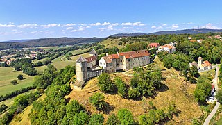
Français : Le château de Belvoir
|
|
| Date | ||
| Source | Own work | |
| Author | JGS25 |
| Camera location | | View this and other nearby images on: OpenStreetMap |
|---|
Licensing[edit]
I, the copyright holder of this work, hereby publish it under the following license:
This file is licensed under the Creative Commons Attribution-Share Alike 4.0 International license.
- You are free:
- to share – to copy, distribute and transmit the work
- to remix – to adapt the work
- Under the following conditions:
- attribution – You must give appropriate credit, provide a link to the license, and indicate if changes were made. You may do so in any reasonable manner, but not in any way that suggests the licensor endorses you or your use.
- share alike – If you remix, transform, or build upon the material, you must distribute your contributions under the same or compatible license as the original.

|
This image was uploaded as part of Wiki Loves Monuments 2018.
|
File history
Click on a date/time to view the file as it appeared at that time.
| Date/Time | Thumbnail | Dimensions | User | Comment | |
|---|---|---|---|---|---|
| current | 07:24, 19 September 2018 | | 3,946 × 2,220 (6.21 MB) | JGS25 (talk | contribs) | User created page with UploadWizard |
You cannot overwrite this file.
File usage on Commons
The following 25 pages use this file:
- Bourgogne-Franche-Comté
- Commons:WikiProject Aviation/recent uploads/2018 September 19
- Category:Airports in Bourgogne-Franche-Comté
- Category:Barns in Bourgogne-Franche-Comté
- Category:Bourgogne-Franche-Comté
- Category:Castles in Bourgogne-Franche-Comté
- Category:Cemeteries in Bourgogne-Franche-Comté
- Category:Churches in Bourgogne-Franche-Comté
- Category:Communautés d'agglomération in Bourgogne-Franche-Comté
- Category:Communautés urbaines in Bourgogne-Franche-Comté
- Category:Energy in Bourgogne-Franche-Comté
- Category:Gothic architecture in Bourgogne-Franche-Comté
- Category:Groups of communes in Bourgogne-Franche-Comté
- Category:History of Bourgogne-Franche-Comté
- Category:Hospitals in Bourgogne-Franche-Comté
- Category:Maps of Bourgogne-Franche-Comté
- Category:Monasteries in Bourgogne-Franche-Comté
- Category:Mountains of Bourgogne-Franche-Comté
- Category:Paintings of Bourgogne-Franche-Comté
- Category:Rail transport in Bourgogne-Franche-Comté
- Category:Railway lines in Bourgogne-Franche-Comté
- Category:Sports in Bourgogne-Franche-Comté
- Category:Stadiums in Bourgogne-Franche-Comté
- Category:Train stations in Bourgogne-Franche-Comté
- Category:Transport in Bourgogne-Franche-Comté
File usage on other wikis
The following other wikis use this file:
- Usage on ar.wikipedia.org
- Usage on arz.wikipedia.org
- Usage on ast.wikipedia.org
- Usage on az.wikipedia.org
- Usage on ca.wikipedia.org
- Usage on ceb.wikipedia.org
- Usage on ce.wikipedia.org
- Usage on cy.wikipedia.org
- Usage on diq.wikipedia.org
- Usage on en.wikipedia.org
- Usage on eo.wikipedia.org
- Usage on fr.wikipedia.org
- Usage on fr.wikinews.org
- Usage on fr.wikivoyage.org
- Usage on gl.wikipedia.org
- Usage on ha.wikipedia.org
- Usage on he.wikipedia.org
- Usage on hy.wikipedia.org
- Usage on is.wikipedia.org
- Usage on ja.wikivoyage.org
- Usage on nn.wikipedia.org
- Usage on no.wikipedia.org
- Usage on oc.wikipedia.org
- Usage on os.wikipedia.org
- Usage on pl.wikipedia.org
- Usage on sl.wikipedia.org
- Usage on sr.wikipedia.org
- Usage on tt.wikipedia.org
- Usage on uk.wikipedia.org
- Usage on vec.wikipedia.org
- Usage on vi.wikipedia.org
- Usage on www.wikidata.org