File:Bharatiya Janata Party in states.png
Jump to navigation
Jump to search
Size of this preview: 511 × 599 pixels. Other resolutions: 205 × 240 pixels | 410 × 480 pixels | 655 × 768 pixels | 874 × 1,024 pixels | 1,594 × 1,868 pixels.
Original file (1,594 × 1,868 pixels, file size: 212 KB, MIME type: image/png)
Captions
Captions
Add a one-line explanation of what this file represents
Summary[edit]
| Description |
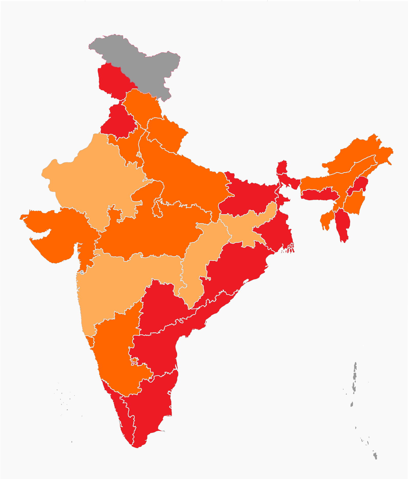
English: States with a chief minister from the Bharatiya Janata Party (BJP).
States which had a chief minister from the BJP.
States which which did not have/had a chief minister from the BJP.
Union territories without a state government. |
| Date | (UTC) |
| Source |
This file was derived from: Indian states by ruling party.png:  |
| Author |
|
| Other versions | Derivative works of this file: Communist Parties of India in states.png |

|
This file may be updated to reflect new information. If you wish to use a specific version of the file without new updates being mirrored, please upload the required version as a separate file. |
Licensing[edit]
I, the copyright holder of this work, hereby publish it under the following license:
This file is licensed under the Creative Commons Attribution 3.0 Unported license.
- You are free:
- to share – to copy, distribute and transmit the work
- to remix – to adapt the work
- Under the following conditions:
- attribution – You must give appropriate credit, provide a link to the license, and indicate if changes were made. You may do so in any reasonable manner, but not in any way that suggests the licensor endorses you or your use.
Original upload log[edit]
This image is a derivative work of the following images:
- File:Indian_states_by_ruling_party.png licensed with Cc-by-3.0
- 2013-07-29T15:56:04Z Wantsallanger 1486x1734 (297488 Bytes) updated j&k to United Nations map. Indian constitution doesnt matter, see wp:worldview
- 2013-07-12T11:40:24Z Vibhijain 1486x1734 (297395 Bytes) trying again
- 2013-07-12T10:03:43Z Vibhijain 1486x1734 (297395 Bytes) Update Jharkhand
- 2013-07-02T12:14:24Z Vibhijain 1486x1734 (297251 Bytes) The reader should know that the claimed areas are a part of the J&K according to the constitution. Its well under NPOV since a line divides the claimed areas and the controlled area.
- 2013-07-02T12:12:46Z Vibhijain 1486x1734 (297251 Bytes) The reader should know that the claimed areas are a part of the J&K according to the constitution. Its well under NPOV since a line divides the claimed areas and the controlled area.
- 2013-06-19T09:20:18Z Wantsallanger 1486x1734 (334271 Bytes) update bihar, fix assam
- 2013-05-09T10:28:15Z Vibhijain 1486x1734 (297621 Bytes) its getting all wrong
- 2013-05-09T10:13:42Z Vibhijain 1486x1734 (297189 Bytes) uploaded the wrong version previous time
- 2013-05-08T15:11:19Z Vibhijain 1486x1734 (297116 Bytes) Karnataka updated
- 2013-04-16T10:31:57Z Wantsallanger 1486x1734 (333823 Bytes) fix maharastra
- 2013-01-21T19:57:16Z Bill william compton 1486x1734 (333726 Bytes) President's rule in Jharkhand
- 2012-12-23T14:14:09Z Vibhijain 1486x1734 (297739 Bytes) fix
- 2012-12-21T06:02:33Z Wantsallanger 1486x1734 (334975 Bytes) bigger font
- 2012-12-20T11:08:20Z Wantsallanger 1486x1734 (336060 Bytes) remove confusing background
- 2012-12-20T05:33:33Z Wantsallanger 1486x1734 (456517 Bytes) fix
- 2012-12-20T05:31:12Z Wantsallanger 1486x1734 (456448 Bytes) updated himachal pradesh results
- 2012-10-03T10:47:45Z Vibhijain 1486x1734 (429794 Bytes) replacing dark green with india green
- 2012-10-03T10:11:16Z Vibhijain 1486x1734 (389219 Bytes) update
- 2012-07-09T14:09:11Z Vibhijain 658x770 (245211 Bytes) fix
- 2012-03-25T12:01:44Z Vibhijain 655x770 (235271 Bytes) Fixed.
- 2012-03-25T11:54:48Z Vibhijain 662x770 (215825 Bytes) '
Uploaded with derivativeFX
File history
Click on a date/time to view the file as it appeared at that time.
| Date/Time | Thumbnail | Dimensions | User | Comment | |
|---|---|---|---|---|---|
| current | 21:26, 13 April 2020 | | 1,594 × 1,868 (212 KB) | Bharatiya29 (talk | contribs) | Update MP |
| 13:09, 18 January 2020 |  | 1,594 × 1,868 (213 KB) | Bharatiya29 (talk | contribs) | various updates | |
| 06:46, 29 July 2019 |  | 1,486 × 1,734 (263 KB) | Bharatiya29 (talk | contribs) | Update Karnataka | |
| 12:34, 24 May 2019 |  | 1,486 × 1,734 (263 KB) | Bharatiya29 (talk | contribs) | update | |
| 14:24, 5 July 2018 |  | 1,486 × 1,734 (262 KB) | Bharatiya29 (talk | contribs) | Not relevant to this map | |
| 11:26, 5 July 2018 |  | 1,486 × 1,734 (307 KB) | Junior Jumper (talk | contribs) | kashmir | |
| 07:03, 30 May 2018 |  | 1,486 × 1,734 (262 KB) | Bharatiya29 (talk | contribs) | update Karnataka | |
| 13:42, 17 May 2018 |  | 1,486 × 1,734 (265 KB) | RaviC (talk | contribs) | Karnataka | |
| 14:07, 4 March 2018 |  | 1,486 × 1,734 (262 KB) | Bharatiya29 (talk | contribs) | update Tripura | |
| 23:38, 17 December 2017 |  | 1,486 × 1,734 (265 KB) | RaviC (talk | contribs) |
You cannot overwrite this file.
File usage on Commons
The following 2 pages use this file:
File usage on other wikis
The following other wikis use this file:
- Usage on hi.wikipedia.org
- Usage on id.wikipedia.org
- Usage on pnb.wikipedia.org
- Usage on te.wikipedia.org
- Usage on ur.wikipedia.org