File:Bijapur-sultanate-map.svg
Jump to navigation
Jump to search

Size of this PNG preview of this SVG file: 565 × 600 pixels. Other resolutions: 226 × 240 pixels | 452 × 480 pixels | 723 × 768 pixels | 964 × 1,024 pixels | 1,929 × 2,048 pixels | 1,651 × 1,753 pixels.
Original file (SVG file, nominally 1,651 × 1,753 pixels, file size: 432 KB)
Captions
Captions
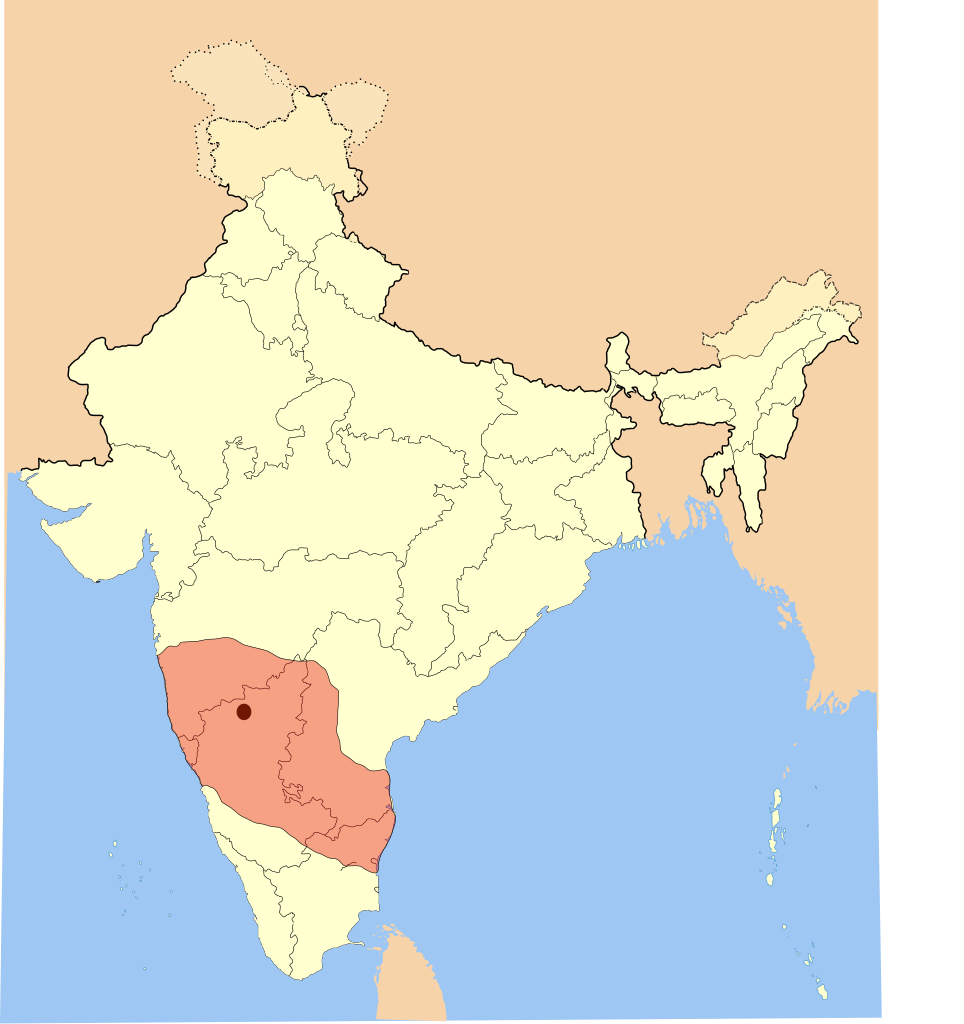
Bijapur or Vijayapura
Summary
[edit]
I used Image:India-locator-map-blank.svg as base and edited myself using inkspace and created it by looking at the following source.
Suryanath U. Kamat, A Concise history of Karnataka from pre-historic times to the present, Jupiter books, MCC, Bangalore, 2001 (Reprinted 2002) OCLC: 7796041 - p329
Note: Original source has overlay of Viajaya Nagara empire, bahamani and Bijapur maps on the same page, I placed only bijapur sultante map here.
| Description | Bijapur Sultante Map |
| Date | |
| Source | Own work |
| Author | Mlpkr |
Licensing
[edit]
I, the copyright holder of this work, hereby publish it under the following licenses:

|
Permission is granted to copy, distribute and/or modify this document under the terms of the GNU Free Documentation License, Version 1.2 or any later version published by the Free Software Foundation; with no Invariant Sections, no Front-Cover Texts, and no Back-Cover Texts. A copy of the license is included in the section entitled GNU Free Documentation License. |
| This file is licensed under the Creative Commons Attribution-Share Alike 3.0 Unported license. | ||
| ||
| This licensing tag was added to this file as part of the GFDL licensing update. |
This file is licensed under the Creative Commons Attribution-Share Alike 2.5 Generic, 2.0 Generic and 1.0 Generic license.
- You are free:
- to share – to copy, distribute and transmit the work
- to remix – to adapt the work
- Under the following conditions:
- attribution – You must give appropriate credit, provide a link to the license, and indicate if changes were made. You may do so in any reasonable manner, but not in any way that suggests the licensor endorses you or your use.
- share alike – If you remix, transform, or build upon the material, you must distribute your contributions under the same or compatible license as the original.
You may select the license of your choice.
File history
Click on a date/time to view the file as it appeared at that time.
| Date/Time | Thumbnail | Dimensions | User | Comment | |
|---|---|---|---|---|---|
| current | 10:33, 27 May 2007 | | 1,651 × 1,753 (432 KB) | Mlpkr (talk | contribs) | I used Image:India-locator-map-blank.svg as base and edited myself using inkspace and created it by looking at the following source. Suryanath U. Kamat, A Concise history of Karnataka from pre-historic times to the present, Jupiter books, MCC, Banga |
| 09:59, 27 May 2007 |  | 1,651 × 1,753 (433 KB) | Mlpkr (talk | contribs) | == Summary == I used Image:India-locator-map-blank.svg as base and edited myself using inkspace and created it by looking at the following source. Suryanath U. Kamat, A Concise history of Karnataka from pre-historic times to the present, Jupiter boo | |
| 09:41, 27 May 2007 |  | 1,651 × 1,753 (432 KB) | Mlpkr (talk | contribs) | I used Image:India-locator-map-blank.svg as base and edited myself using inkspace and created it by looking at the following source. Suryanath U. Kamat, A Concise history of Karnataka from pre-historic times to the present, Jupiter books, MCC, Banga |
You cannot overwrite this file.
File usage on Commons
The following 2 pages use this file:
File usage on other wikis
The following other wikis use this file:
- Usage on ast.wikipedia.org
- Usage on az.wikipedia.org
- Usage on ca.wikipedia.org
- Usage on ckb.wikipedia.org
- Usage on de.wikipedia.org
- Usage on en.wikipedia.org
- Usage on es.wikipedia.org
- Usage on fa.wikipedia.org
- Usage on id.wikipedia.org
- Usage on ja.wikipedia.org
- Usage on kn.wikipedia.org
- Usage on ko.wikipedia.org
- Usage on mr.wikipedia.org
- Usage on nl.wikipedia.org
- Usage on pnb.wikipedia.org
- Usage on pt.wikipedia.org
- Usage on ru.wikipedia.org
- Usage on skr.wikipedia.org
- Usage on te.wikipedia.org
- Usage on tg.wikipedia.org
- Usage on tr.wikipedia.org
- Usage on uk.wikipedia.org
- Usage on ur.wikipedia.org
- Usage on uz.wikipedia.org
- Usage on www.wikidata.org
- Usage on zh.wikipedia.org