File:Bundesarchiv Bild 183-11408-0005, Dresden, zerstörtes Stadtzentrum.jpg
Jump to navigation
Jump to search
No higher resolution available.
Bundesarchiv_Bild_183-11408-0005,_Dresden,_zerstörtes_Stadtzentrum.jpg (800 × 465 pixels, file size: 58 KB, MIME type: image/jpeg)
Captions
Captions
Add a one-line explanation of what this file represents
Summary[edit]
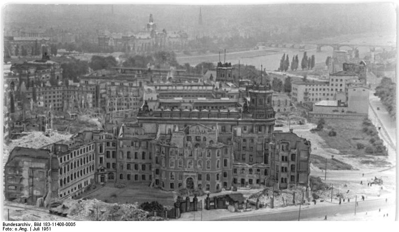
| Dresden, zerstörtes Stadtzentrum
( |
|||||||||||||||||||||||||||
|---|---|---|---|---|---|---|---|---|---|---|---|---|---|---|---|---|---|---|---|---|---|---|---|---|---|---|---|
| Photographer |
Unknown |
||||||||||||||||||||||||||
| Title |
Dresden, zerstörtes Stadtzentrum |
||||||||||||||||||||||||||
| Original caption |
For documentary purposes the German Federal Archive often retained the original image captions, which may be erroneous, biased, obsolete or politically extreme. ADN-ZB/Archiv Dresden nach dem britisch-amerikanischen Luftangriff am 13./14.2.1945. |
||||||||||||||||||||||||||
| Description |
|
||||||||||||||||||||||||||
| Depicted place | Dresden | ||||||||||||||||||||||||||
| Date | July 1951 | ||||||||||||||||||||||||||
| Collection |
|
||||||||||||||||||||||||||
| Current location |
Allgemeiner Deutscher Nachrichtendienst - Zentralbild (Bild 183) |
||||||||||||||||||||||||||
| Accession number | |||||||||||||||||||||||||||
| Source |
|
||||||||||||||||||||||||||

| Camera location | | View this and other nearby images on: OpenStreetMap |
|---|
Licensing[edit]
This file is licensed under the Creative Commons Attribution-Share Alike 3.0 Germany license.
Attribution: Bundesarchiv, Bild 183-11408-0005 / CC-BY-SA
- You are free:
- to share – to copy, distribute and transmit the work
- to remix – to adapt the work
- Under the following conditions:
- attribution – You must give appropriate credit, provide a link to the license, and indicate if changes were made. You may do so in any reasonable manner, but not in any way that suggests the licensor endorses you or your use.
- share alike – If you remix, transform, or build upon the material, you must distribute your contributions under the same or compatible license as the original.

| Object location | | View this and other nearby images on: OpenStreetMap |
|---|
File history
Click on a date/time to view the file as it appeared at that time.
| Date/Time | Thumbnail | Dimensions | User | Comment | |
|---|---|---|---|---|---|
| current | 16:30, 9 December 2008 | | 800 × 465 (58 KB) | BArchBot (talk | contribs) | == {{int:filedesc}} == {{Information |Description={{BArch-description |comment= <!-- add translations and/or more description --> |biased=<!-- if the original description text is biased, write here why! --> |headline='''Dresden, zerstörtes Stadtzentrum'' |
You cannot overwrite this file.
File usage on Commons
The following page uses this file:
File usage on other wikis
The following other wikis use this file:
- Usage on de.wikipedia.org
- Usage on de.wikibooks.org
- Usage on en.wikipedia.org
- Usage on fr.wikipedia.org