File:C71188s5 Ant.Map Cape Adare.jpg
קפיצה לניווט
קפיצה לחיפוש
גודל התצוגה המקדימה הזאת: 557 × 599 פיקסלים. רזולוציות אחרות: 223 × 240 פיקסלים | 446 × 480 פיקסלים | 714 × 768 פיקסלים | 952 × 1,024 פיקסלים | 1,903 × 2,048 פיקסלים | 2,877 × 3,096 פיקסלים.
לקובץ המקורי (2,877 × 3,096 פיקסלים, גודל הקובץ: 1.53 מ"ב, סוג MIME: image/jpeg)
כיתובים
כיתובים
נא להוסיף משפט שמסביר מה הקובץ מייצג
תקציר
[עריכה]
| תיאור |
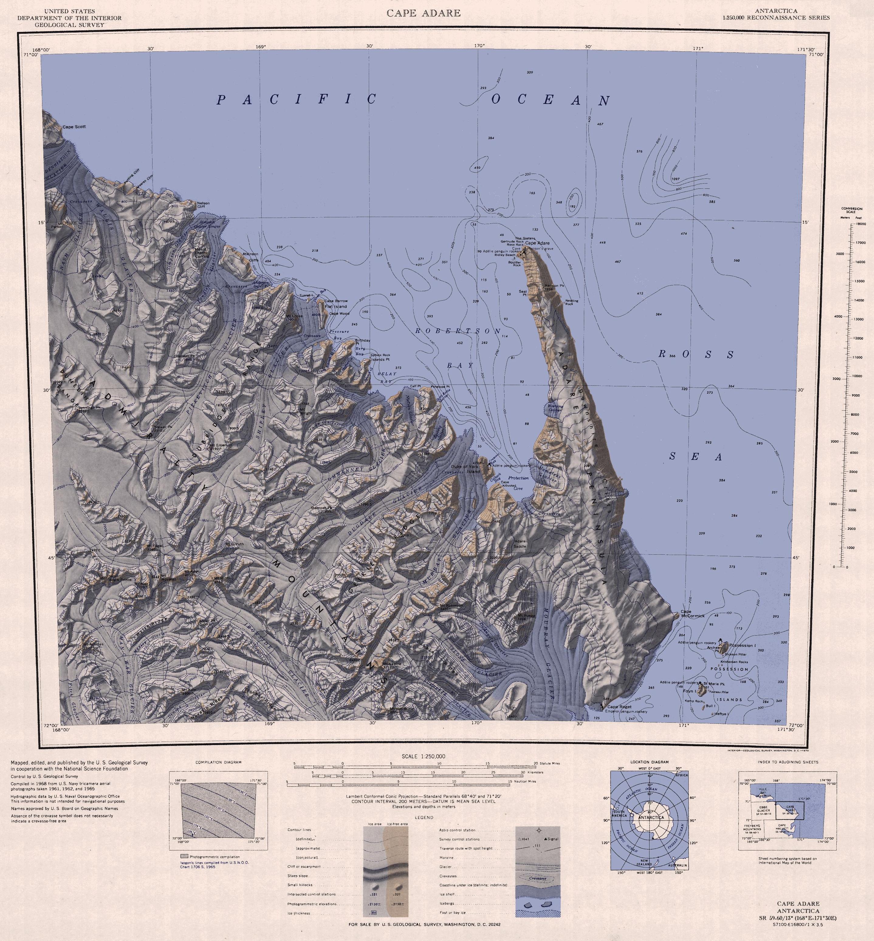
English: 1:250,000-scale topographic reconnaissance map of the Cape Adare region in Antarctica (168°E - 171°30'E, 71°S - 72°S). Mapped, edited and published by the U.S. Geological Survey in cooperation with the National Science Foundation. |
|||
| תאריך יצירה | ||||
| מקור | http://usarc.usgs.gov/drg_dload.shtml | |||
| יוצר | United States Geological Survey | |||
| אישורים והיתרים (שימוש חוזר בקובץ זה) |
|
|||
| גרסאות אחרות |
Derivative works of this file: |
היסטוריית הקובץ
ניתן ללחוץ על תאריך/שעה כדי לראות את הקובץ כפי שנראה באותו זמן.
| תאריך/שעה | תמונה ממוזערת | ממדים | משתמש | הערה | |
|---|---|---|---|---|---|
| נוכחית | 12:47, 26 בנובמבר 2015 | | 3,096 × 2,877 (1.53 מ"ב) | ValeriySh (שיחה | תרומות) | Обрізка зайвого поля |
| 16:43, 3 באפריל 2005 |  | 3,260 × 3,506 (1.67 מ"ב) | Achim Raschka (שיחה | תרומות) | Map of Antarctica by the United States Antarctic Ressource Center of the US Geological Society. {{PD-US}} Copyrights and Trademarks USGS-authored or produced data and information are in the public domain. While the content of most USGS web pages is in th |
אין באפשרותך לדרוס את הקובץ הזה.
שימוש בקובץ
הדפים הבאים משתמשים בקובץ הזה:
שימוש גלובלי בקובץ
אתרי הוויקי השונים הבאים משתמשים בקובץ זה:
- שימוש באתר ar.wikipedia.org
- שימוש באתר ast.wikipedia.org
- שימוש באתר az.wikipedia.org
- שימוש באתר be.wikipedia.org
- שימוש באתר bg.wikipedia.org
- שימוש באתר ceb.wikipedia.org
- שימוש באתר de.wikipedia.org
- שימוש באתר el.wikipedia.org
- שימוש באתר en.wikipedia.org
- שימוש באתר eo.wikipedia.org
- שימוש באתר es.wikipedia.org
- שימוש באתר fr.wikipedia.org
- שימוש באתר he.wikipedia.org
- שימוש באתר id.wikipedia.org
- שימוש באתר it.wikipedia.org
צפייה בשימושים גלובליים נוספים של קובץ זה.