File:COVID-19 Active Cases in Australia proportional to population.svg
Jump to navigation
Jump to search

Size of this PNG preview of this SVG file: 512 × 512 pixels. Other resolutions: 240 × 240 pixels | 480 × 480 pixels | 768 × 768 pixels | 1,024 × 1,024 pixels | 2,048 × 2,048 pixels.
Original file (SVG file, nominally 512 × 512 pixels, file size: 73 KB)
Captions
Captions
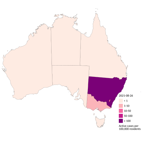
Colour-coded map of Active COVID-19 cases in Australia by state/territory proportional to population
Summary
[edit]
| Description |
English: Map of Australia indicating number of Active COVID-19 cases[1] by state/territory proportional to population. Note that colour of smaller islands matches the state and does not indicate the presence or not of a case on the small island. The inhabited territories of Jervis Bay Territory, Australian Antarctic Territory, Christmas Island, the Cocos (Keeling) Islands, the Coral Sea Islands, and Norfolk Island are not shown. |
| Date | |
| Source | Own work |
| Author | Aeonx |
Licensing
[edit]
I, the copyright holder of this work, hereby publish it under the following license:
This file is licensed under the Creative Commons Attribution-Share Alike 4.0 International license.
- You are free:
- to share – to copy, distribute and transmit the work
- to remix – to adapt the work
- Under the following conditions:
- attribution – You must give appropriate credit, provide a link to the license, and indicate if changes were made. You may do so in any reasonable manner, but not in any way that suggests the licensor endorses you or your use.
- share alike – If you remix, transform, or build upon the material, you must distribute your contributions under the same or compatible license as the original.
File history
Click on a date/time to view the file as it appeared at that time.
| Date/Time | Thumbnail | Dimensions | User | Comment | |
|---|---|---|---|---|---|
| current | 04:53, 27 August 2021 | | 512 × 512 (73 KB) | Aeonx (talk | contribs) | Uploaded own work with UploadWizard |
You cannot overwrite this file.
File usage on Commons
There are no pages that use this file.
File usage on other wikis
The following other wikis use this file:
- Usage on es.wikipedia.org
- Usage on jv.wikipedia.org
- Usage on ro.wikipedia.org