File:Cambridgeshire UK locator map 2010.svg
קפיצה לניווט
קפיצה לחיפוש

גודל התצוגה המקדימה הזאת מסוג PNG של קובץ ה־SVG הזה: 494 × 600 פיקסלים. רזולוציות אחרות: 198 × 240 פיקסלים | 395 × 480 פיקסלים | 633 × 768 פיקסלים | 843 × 1,024 פיקסלים | 1,687 × 2,048 פיקסלים | 1,108 × 1,345 פיקסלים.
לקובץ המקורי (קובץ SVG, הגודל המקורי: 1,108 × 1,345 פיקסלים, גודל הקובץ: 302 ק"ב)
כיתובים
כיתובים
נא להוסיף משפט שמסביר מה הקובץ מייצג
תקציר[עריכה]
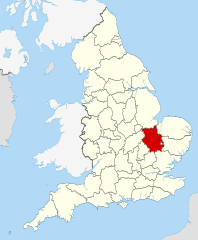
| תיאור | Location of the ceremonial county of Cambridgeshire within England. |
| תאריך יצירה | |
| מקור |
National Geospatial-Intelligence Agency
|
| יוצר | Nilfanion |
רישיון[עריכה]
אני, בעל זכויות היוצרים על היצירה הזאת, מפרסם אותה בזאת תחת הרישיונות הבאים:
הקובץ הזה מתפרסם לפי תנאי רישיון קריאייטיב קומונז ייחוס-שיתוף זהה 3.0 לא מותאם.
- הנכם רשאים:
- לשתף – להעתיק, להפיץ ולהעביר את העבודה
- לערבב בין עבודות – להתאים את העבודה
- תחת התנאים הבאים:
- ייחוס – יש לתת ייחוס הולם, לתת קישור לרישיון, ולציין אם נעשו שינויים. אפשר לעשות את זה בכל צורה סבירה, אבל לא בשום צורה שמשתמע ממנה שמעניק הרישיון תומך בך או בשימוש שלך.
- שיתוף זהה – אם תיצרו רמיקס, תשנו, או תבנו על החומר, חובה עליכם להפיץ את התרומות שלך לפי תנאי רישיון זהה או תואם למקור.

|
מוענקת בכך הרשות להעתיק, להפיץ או לשנות את המסמך הזה, לפי תנאי הרישיון לשימוש חופשי במסמכים של גנו, גרסה 1.2 או כל גרסה מאוחרת יותר שתפורסם על־ידי המוסד לתוכנה חופשית; ללא פרקים קבועים, ללא טקסט עטיפה קדמית וללא טקסט עטיפה אחורית. עותק של הרישיון כלול בפרק שכותרתו הרישיון לשימוש חופשי במסמכים של גנו. |
הנכם מוזמנים לבחור את הרישיון הרצוי בעיניכם.

|
This is one of the images forming part of the Valued image set: Locator maps of the Ceremonial counties of England on Wikimedia Commons. The image set has been assessed under the valued image set criteria and is considered the most valued set on Commons within the scope:
Locator maps of the Ceremonial counties of England
You can see its nomination at Commons:Valued image candidates/Locator maps of English ceremonial counties. |
היסטוריית הקובץ
ניתן ללחוץ על תאריך/שעה כדי לראות את הקובץ כפי שנראה באותו זמן.
| תאריך/שעה | תמונה ממוזערת | ממדים | משתמש | הערה | |
|---|---|---|---|---|---|
| נוכחית | 22:31, 23 בנובמבר 2010 | | 1,345 × 1,108 (302 ק"ב) | Nilfanion (שיחה | תרומות) | == Summary == {{Information |Description=Location of the ceremonial county of Cambridgeshire within England. |Source=Ordnance Survey [https://www.ordnancesurvey.co.uk/opendatadownload/products.html OpenData]: *Co |
אין באפשרותך לדרוס את הקובץ הזה.
שימוש בקובץ
הדפים הבאים משתמשים בקובץ הזה:
- Valued image set: Locator maps of the Ceremonial counties of England
- Commons:Valued image candidates/Locator maps of English ceremonial counties
- Category:Alumni by school in Cambridgeshire
- Category:Births in Cambridgeshire
- Category:Bridges in Cambridgeshire
- Category:Cambridgeshire
- Category:Cambridgeshire in the 16th century
- Category:Cambridgeshire in the 19th century
- Category:Cambridgeshire in the 2000s
- Category:Cambridgeshire in the 2010s
- Category:Cambridgeshire in the 20th century
- Category:Cambridgeshire in the 21st century
- Category:Canals in Cambridgeshire
- Category:Castles in Cambridgeshire
- Category:Cemeteries in Cambridgeshire
- Category:Deaths in Cambridgeshire
- Category:Disused railway stations in Cambridgeshire
- Category:Hospitals in Cambridgeshire
- Category:Local government in Cambridgeshire
- Category:Maps of Cambridgeshire
- Category:Meadows in Cambridgeshire
- Category:Populated places in Cambridgeshire
- Category:Rail transport in Cambridgeshire
- Category:Railway stations in Cambridgeshire
- Category:Rivers of Cambridgeshire
- Category:Roads in Cambridgeshire
- Category:Sports venues in Cambridgeshire
- Category:Towers in Cambridgeshire
- Category:Tunnels in Cambridgeshire
- Category:Views of Cambridgeshire
- Category:Villages in Cambridgeshire
- Category:Visitor attractions in Cambridgeshire
- Category:Windmills in Cambridgeshire
שימוש גלובלי בקובץ
אתרי הוויקי השונים הבאים משתמשים בקובץ זה:
- שימוש באתר af.wikipedia.org
- שימוש באתר an.wikipedia.org
- שימוש באתר ar.wikipedia.org
- שימוש באתר ast.wikipedia.org
- שימוש באתר be-tarask.wikipedia.org
- שימוש באתר bg.wikipedia.org
- שימוש באתר br.wikipedia.org
- שימוש באתר ca.wikipedia.org
- שימוש באתר ceb.wikipedia.org
- שימוש באתר cs.wikipedia.org
- שימוש באתר dag.wikipedia.org
- שימוש באתר en.wikipedia.org
- Cambridgeshire
- Eye Green
- Paxton Pits Nature Reserve
- Northborough, Cambridgeshire
- Carlton, Cambridgeshire
- Cambridge Business Park
- Brinkley, Cambridgeshire
- Rivey Hill
- Newmarket Ridge
- Free School Lane
- Odsey
- New England, Peterborough
- Westwick, Cambridgeshire
- Upend
- Upton, Peterborough
- Denton and Caldecote
- The Stukeleys
- Template:Cambridgeshire-geo-stub
- Stanground North
- Bainton, Cambridgeshire
- Barham and Woolley
- Old Fletton Urban District
- Queen Adelaide, Cambridgeshire
- Bythorn and Keyston
- Netherton, Peterborough
- Conington, South Cambridgeshire
- Serpentine Green
- Chettisham
- Doddington, Cambridgeshire
- Wothorpe
- Stamford Baron St Martin
- St Martin's Without
- Little Downham
- Coveney, Cambridgeshire
- Glinton, Cambridgeshire
- Melbourn Science Park
צפייה בשימושים גלובליים נוספים של קובץ זה.