File:Canada provinces evolution-250.gif
Jump to navigation
Jump to search
No higher resolution available.
Canada_provinces_evolution-250.gif (250 × 216 pixels, file size: 211 KB, MIME type: image/gif, looped, 18 frames, 54 s)
Captions
Captions
Add a one-line explanation of what this file represents
Summary[edit]
| Description |
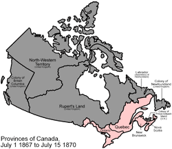
English: Scaled down version of Image:Canada provinces evolution.gif
An animated GIF of the evolution of Canada's internal borders, from the formation of the dominion to the present. PINK Province BROWN Territory GRAY Foreign land FUCHSIA Disputed land |
||||||
| Source | Own work | ||||||
| Author | Made by User:Golbez. | ||||||
| Other versions |
|


Licensing[edit]
This file is licensed under the Creative Commons Attribution 2.5 Generic license.
- You are free:
- to share – to copy, distribute and transmit the work
- to remix – to adapt the work
- Under the following conditions:
- attribution – You must give appropriate credit, provide a link to the license, and indicate if changes were made. You may do so in any reasonable manner, but not in any way that suggests the licensor endorses you or your use.
File history
Click on a date/time to view the file as it appeared at that time.
| Date/Time | Thumbnail | Dimensions | User | Comment | |
|---|---|---|---|---|---|
| current | 23:05, 6 November 2006 | | 250 × 216 (211 KB) | Qyd (talk | contribs) | Scaled down version of Image:Canada provinces evolution.gif An animated GIF of the evolution of Canada's internal borders, from the formation of the dominion to the present. Pink = provinces; brown = territories; gray = foreign lands; kinda fuschia |
You cannot overwrite this file.
File usage on Commons
The following 2 pages use this file:
File usage on other wikis
The following other wikis use this file:
- Usage on be-tarask.wikipedia.org
- Usage on be.wikipedia.org
- Usage on en.wikipedia.org
- Usage on fa.wikipedia.org
- Usage on lez.wikipedia.org
- Usage on oc.wikipedia.org
- Usage on ru.wikipedia.org