File:Cannel City-Amburgy Coal Zone (Pikeville Formation, Middle Pennsylvanian; Jackson North roadcut, Breathitt County, Kentucky, USA) 1 (16798235747).jpg

Original file (4,000 × 3,000 pixels, file size: 4.52 MB, MIME type: image/jpeg)
Captions
Captions
Summary[edit]
_1_(16798235747).jpg&action=edit§ion=1)
| Description |
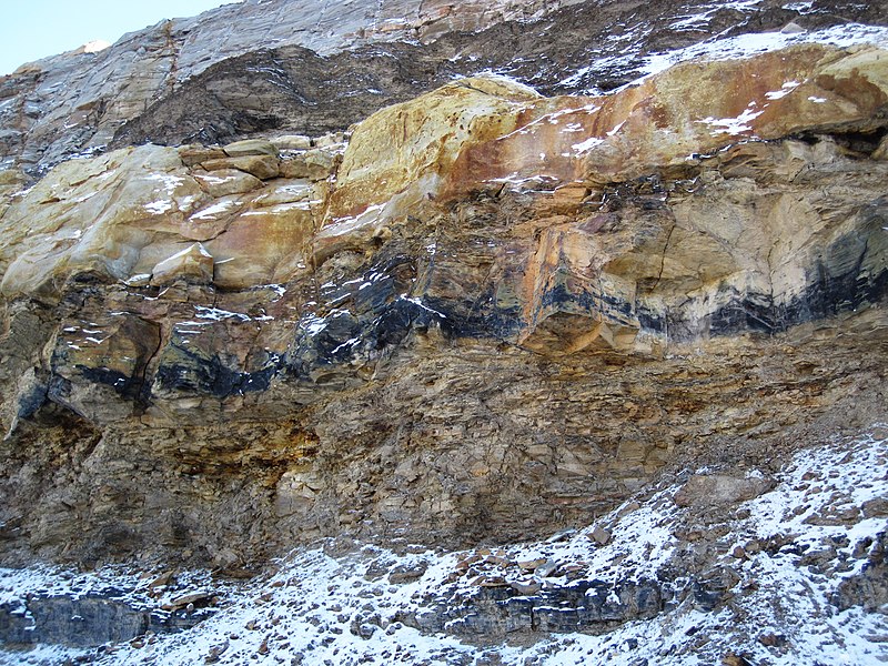
Cannel City-Amburgy Coal Zone in the Pennsylvanian of Kentucky, USA. This exposure is part of a relatively new roadcut along new Route 15, north of the town of Jackson, Kentucky, USA. The exposure has Pennsylvanian-aged cyclothemic sedimentary rocks of the Breathitt Group (formerly the Breathitt Formation). Shown above is the Cannel City-Amburgy Coal Zone. The two black-colored horizons are coal beds. The upper coal bed is cannel coal. The lower is bituminous coal. Cannel coal is a scarce, fossil spore-rich variety of coal - it is hard, has a velvety to satiny luster, little to no stratification, and a conchoidal fracture. Bituminous coal is a common variety of coal - it is relatively soft, sooty, has blocky-weathering, is well stratified and laminated, and has patches of glassy-lustered material (vitrain) in and among dull-lustered material. The cannel coal horizon was economically significant in the early 20th century, and the unit was extensively mined in eastern Kentucky. Published info. about the locality shown above (see Greb & Eble, 2014) indicates that the cannel coal is 33% ash and 1.6% sulfur. The macerals in the cannel coal include liptinite (~47%), inertinite (~31%), and vitrinite (~22%). Plant microfossils from the cannel coal are principally lycopsid tree spores and calamite sphenophyte spores. The cannel coal horizon itself represents an ancient lake formed in a basement fault-generated depression. The grayish to yellowish-weathering, cliff-like unit at the top is a channel sandstone. The gray to gray-brown unit between the two coal horizons is shale. Below the lower coal bed is another channel sandstone (= covered in talus in this shot). Stratigraphy: Cannel City-Amburgy Coal Zone, upper Pikeville Formation, Breathitt Group, lower Atokan Series (Duckmantian), lower Middle Pennsylvanian Location: Jackson North outcrop - large roadcut on the eastern side of new Rt. 15, just south of southbound old Rt. 15-new Rt. 15 split, north of Jackson, north-central Breathitt County, eastern Kentucky, USA (37° 34’ 53.95” North, 83° 23’ 07.99” West) Reference cited: Greb & Eble (2014) - Cannel coals of the Cannel City-Amburgy Coal Bed (Pikeville Formation, Middle Pennsylvanian); evidence for possible fault-generated lakes. Geological Society of America Abstracts with Programs 46(6): 604. |
| Date | |
| Source | Cannel City-Amburgy Coal Zone (Pikeville Formation, Middle Pennsylvanian; Jackson North roadcut, Breathitt County, Kentucky, USA) 1 |
| Author | James St. John |
Licensing[edit]
_1_(16798235747).jpg&action=edit§ion=2)
- You are free:
- to share – to copy, distribute and transmit the work
- to remix – to adapt the work
- Under the following conditions:
- attribution – You must give appropriate credit, provide a link to the license, and indicate if changes were made. You may do so in any reasonable manner, but not in any way that suggests the licensor endorses you or your use.
| This image was originally posted to Flickr by James St. John at https://flickr.com/photos/47445767@N05/16798235747 (archive). It was reviewed on 6 December 2019 by FlickreviewR 2 and was confirmed to be licensed under the terms of the cc-by-2.0. |
File history
Click on a date/time to view the file as it appeared at that time.
| Date/Time | Thumbnail | Dimensions | User | Comment | |
|---|---|---|---|---|---|
| current | 03:16, 6 December 2019 | | 4,000 × 3,000 (4.52 MB) | Ser Amantio di Nicolao (talk | contribs) | Transferred from Flickr via #flickr2commons |
You cannot overwrite this file.
File usage on Commons
There are no pages that use this file.
File usage on other wikis
The following other wikis use this file:
- Usage on uk.wikipedia.org
_1_(16798235747).jpg&oldid=847370972)