File:Carolingian and Byzantine Empires 814.png
Vai alla navigazione
Vai alla ricerca
Dimensioni di questa anteprima: 800 × 470 pixel. Altre risoluzioni: 320 × 188 pixel | 640 × 376 pixel | 1 024 × 602 pixel | 1 280 × 753 pixel | 2 560 × 1 505 pixel | 3 840 × 2 258 pixel.
File originale (3 840 × 2 258 pixel, dimensione del file: 700 KB, tipo MIME: image/png)
Didascalie
Didascalie
Aggiungi una brevissima spiegazione di ciò che questo file rappresenta
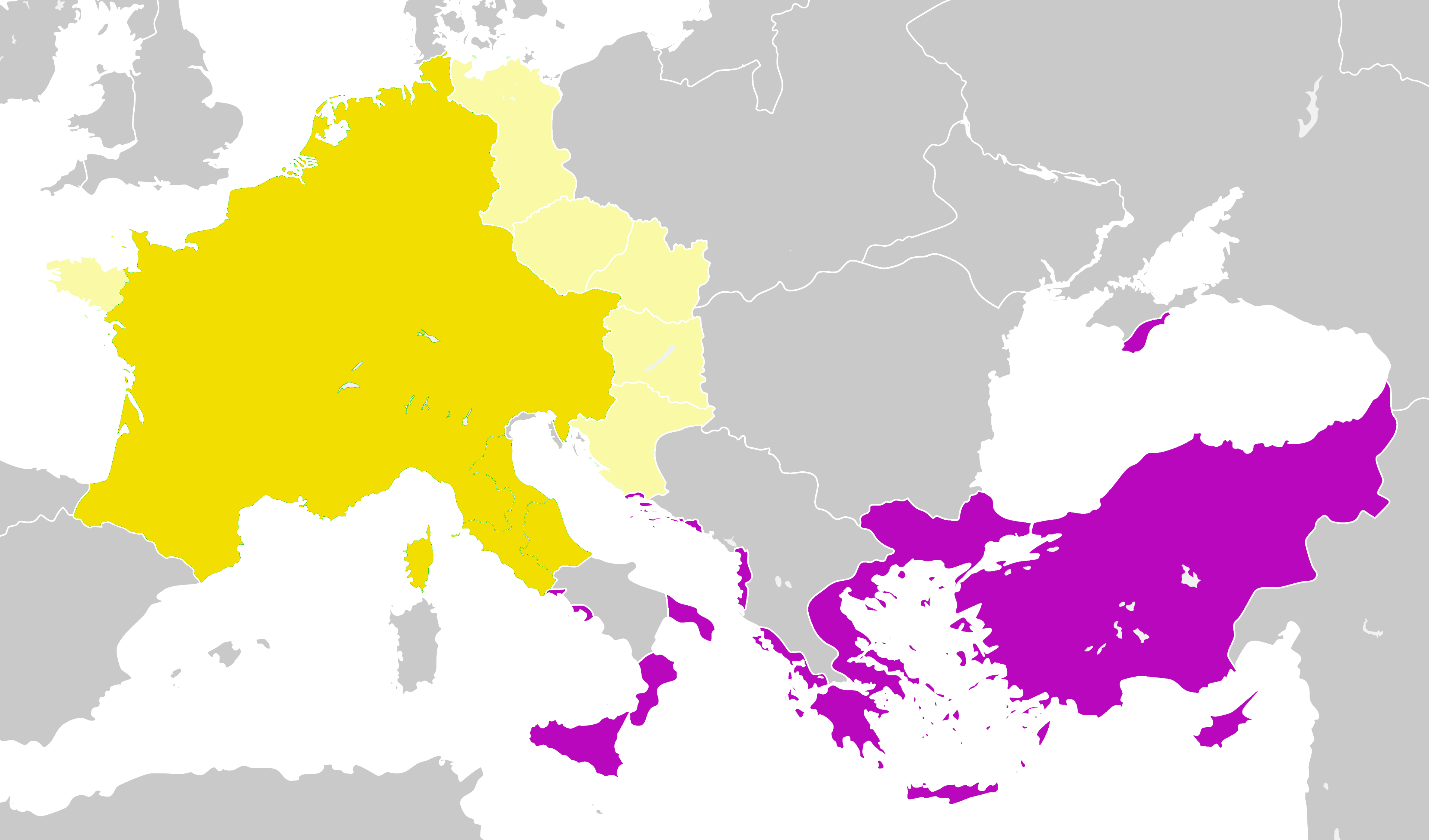
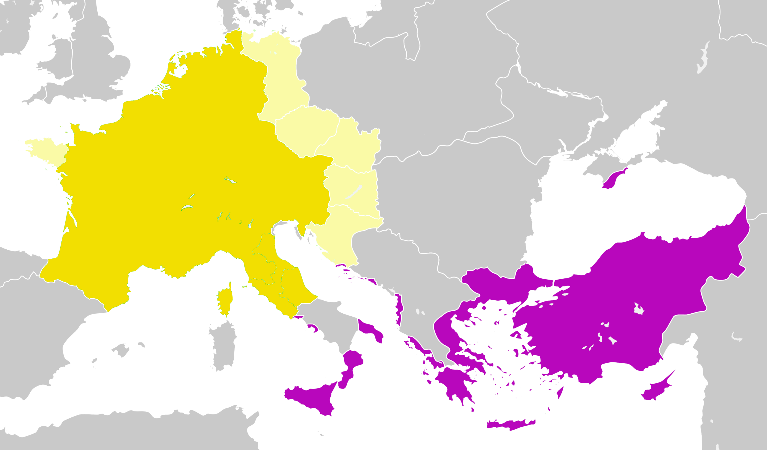
The Carolingian Empire and the Byzantine Empire in 814 AD

Dettagli[modifica]
| Descrizione |
English: The Carolingian Empire and the Byzantine Empire in 814 AD |
| Data | |
| Fonte | Francia 814.svg |
| Autore |
User:Alphathon User:Ichthyovenator (derivative work forbidden by the rule "COM:CROP" usually applied to old maps scanned, but for the current ones created here, normally we should could improve each other. Since this is not the case for this map, I create another more exact version here Carolingian and Eastern Roman empires 814.png.) |
Licenza[modifica]
Questo file è disponibile in base alla licenza Creative Commons Attribuzione-Condividi allo stesso modo 4.0 Internazionale
- Tu sei libero:
- di condividere – di copiare, distribuire e trasmettere quest'opera
- di modificare – di adattare l'opera
- Alle seguenti condizioni:
- attribuzione – Devi fornire i crediti appropriati, un collegamento alla licenza e indicare se sono state apportate modifiche. Puoi farlo in qualsiasi modo ragionevole, ma non in alcun modo che suggerisca che il licenziante approvi te o il tuo uso.
- condividi allo stesso modo – Se remixi, trasformi o sviluppi il materiale, devi distribuire i tuoi contributi in base alla stessa licenza o compatibile all'originale.
Cronologia del file
Fare clic su un gruppo data/ora per vedere il file come si presentava nel momento indicato.
| Data/Ora | Miniatura | Dimensioni | Utente | Commento | |
|---|---|---|---|---|---|
| attuale | 05:38, 26 gen 2022 | | 3 840 × 2 258 (700 KB) | GPinkerton (discussione | contributi) | Reverted to version as of 12:33, 2 January 2020 (UTC) COM:CROP Rules apply to you too |
| 18:19, 31 dic 2021 |  | 3 840 × 2 258 (608 KB) | Claude Zygiel (discussione | contributi) | WP:CROP rules are not for restore mistakes, a map must be conform to Historic atlases | |
| 04:36, 27 set 2021 |  | 3 840 × 2 258 (700 KB) | GPinkerton (discussione | contributi) | Reverted to version as of 12:33, 2 January 2020 (UTC) COM:CROP | |
| 14:54, 18 giu 2020 |  | 3 840 × 2 258 (597 KB) | Claude Zygiel (discussione | contributi) | Venice: byzantine until 990; Church state: autonomous; Slavs: also in Peloponnesus (Ezerits, Melinges); separate Western from Eastern Slavs, Avarian from Bulgarian states and Etelköz from the Khazarian state; removed the modern dam reservoirs. | |
| 12:33, 2 gen 2020 |  | 3 840 × 2 258 (700 KB) | Ichthyovenator (discussione | contributi) | Fixed image being a bit too bright | |
| 21:24, 1 gen 2020 |  | 3 840 × 2 258 (688 KB) | Ichthyovenator (discussione | contributi) | User created page with UploadWizard |
Impossibile sovrascrivere questo file.
Utilizzo del file
Le seguenti 2 pagine usano questo file:
Utilizzo globale del file
Anche i seguenti wiki usano questo file:
- Usato nelle seguenti pagine di en.wikipedia.org:
- Usato nelle seguenti pagine di zh.wikipedia.org: