File:CarteNouvelledesRoyaumesdeGalizieetLodomerie large.jpg

Original file (5,722 × 4,971 pixels, file size: 7.07 MB, MIME type: image/jpeg)
Captions
Captions
Summary[edit]
| Description |
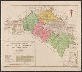
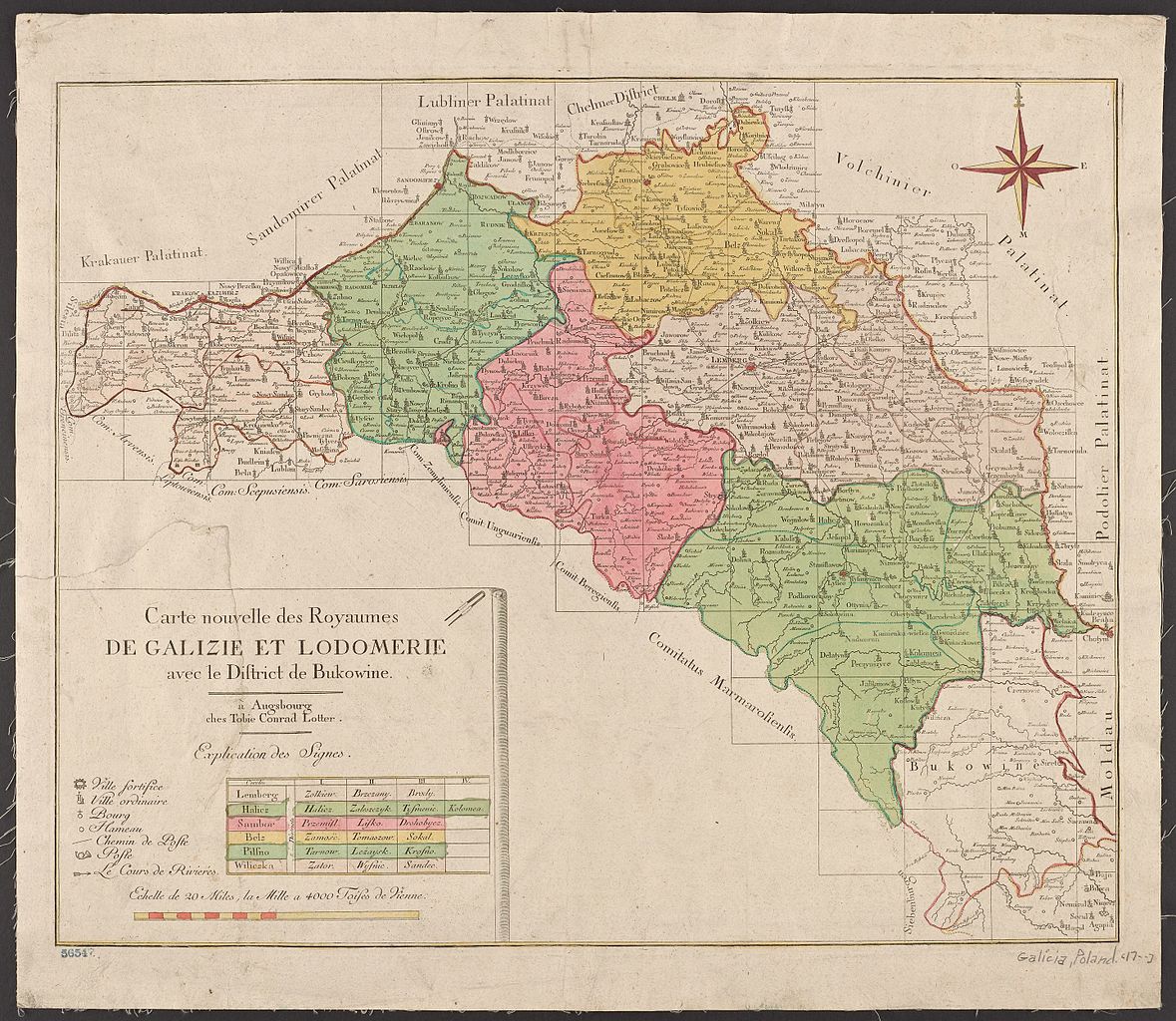
Українська: Адміністративний поділ Королівства Галичини та Володимирії у 1777-1782 роках |
| Date | кінець XVIII століття |
| Source | http://report.if.ua/istoriya/biblioteka-nyu-jorka-vyklala-unikalnu-kartu-galychyny-j-bukovyny-18-stolittya-foto/ |
| Author | створена у ХVIII столітті, видали в місті Аусбург. |
Licensing[edit]
|
This is a faithful photographic reproduction of a two-dimensional, public domain work of art. The work of art itself is in the public domain for the following reason:
The official position taken by the Wikimedia Foundation is that "faithful reproductions of two-dimensional public domain works of art are public domain". This photographic reproduction is therefore also considered to be in the public domain in the United States. In other jurisdictions, re-use of this content may be restricted; see Reuse of PD-Art photographs for details. {{PD-Art}} template without license parameter: please specify why the underlying work is public domain in both the source country and the United States
(Usage: {{PD-Art|1=|deathyear=''year of author's death''|country=''source country''}}, where parameter 1= can be PD-old-auto, PD-old-auto-expired, PD-old-auto-1996, PD-old-100 or similar. See Commons:Multi-license copyright tags for more information.) | ||||
File history
Click on a date/time to view the file as it appeared at that time.
| Date/Time | Thumbnail | Dimensions | User | Comment | |
|---|---|---|---|---|---|
| current | 09:29, 14 January 2016 | | 5,722 × 4,971 (7.07 MB) | Бучач-Львів (talk | contribs) | User created page with UploadWizard |
You cannot overwrite this file.
File usage on Commons
There are no pages that use this file.
File usage on other wikis
The following other wikis use this file:
- Usage on ast.wikipedia.org
- Usage on be.wikipedia.org
- Usage on de.wikipedia.org
- Usage on en.wikipedia.org
- Usage on mk.wikipedia.org
- Usage on pl.wikipedia.org
- Usage on ro.wikipedia.org
- Usage on uk.wikipedia.org
- Історія України
- Чортків
- Язловець
- Теребовля
- Вузлове (село)
- Глиняни
- Золотий Потік
- Буцики
- Бариш (село)
- Королівство Галичини та Володимирії
- Сновидів
- Поділля (Чортківський район)
- Нижнів
- Верхня Білка
- Погірці
- Білий Камінь (Золочівський район)
- Червоногрод
- Стрийський округ
- Тернопільський округ
- Чортківський округ (Королівство Галичини та Володимирії)
- Бережанський округ
- Коломийський округ
- Станиславівський округ
- Самбірський округ
- Львівський округ
- Сяноцький округ
- Перемиський округ
- Жовківський округ
- Ряшівський округ
- Тракт Глинянський
- Галицький округ
- Історія Бучача
- Підлісся (Гримайлів)
- Городло
- Заліщицький округ
- Usage on www.wikidata.org