File:Caucasus 1311 AD map de.png
Jump to navigation
Jump to search

Size of this preview: 771 × 600 pixels. Other resolutions: 309 × 240 pixels | 617 × 480 pixels | 988 × 768 pixels | 1,280 × 995 pixels | 2,560 × 1,991 pixels | 2,995 × 2,329 pixels.
Original file (2,995 × 2,329 pixels, file size: 3.38 MB, MIME type: image/png)
Captions
Captions
Add a one-line explanation of what this file represents
Summary[edit]
| Description |
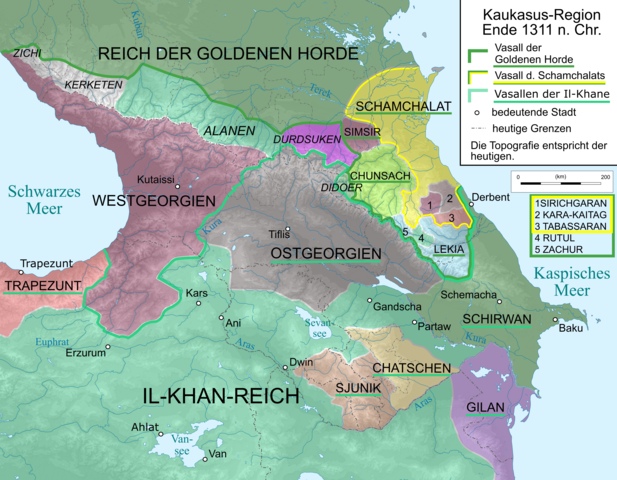
English: Map of Caucasus Region around 1380 in German.
Deutsch: Kaukasus-Region um 1311 n. Chr. Quellen sind: * Michael Kemper: Herrschaft, Recht und Islam in Daghestan. Von den Khanaten und Gemeindebünden zum ǧihād-Staat. Wiesbaden 2005. S. 30–111.
|
| Date | |
| Source | Own work, derivative of File:Caucasus_topographic_map-fr.svg |
| Author |
|
| Other versions |
 |
Licensing[edit]
I, the copyright holder of this work, hereby publish it under the following licenses:

|
Permission is granted to copy, distribute and/or modify this document under the terms of the GNU Free Documentation License, Version 1.2 or any later version published by the Free Software Foundation; with no Invariant Sections, no Front-Cover Texts, and no Back-Cover Texts. A copy of the license is included in the section entitled GNU Free Documentation License. |
This file is licensed under the Creative Commons Attribution-Share Alike 3.0 Unported, 2.5 Generic, 2.0 Generic and 1.0 Generic license.
- You are free:
- to share – to copy, distribute and transmit the work
- to remix – to adapt the work
- Under the following conditions:
- attribution – You must give appropriate credit, provide a link to the license, and indicate if changes were made. You may do so in any reasonable manner, but not in any way that suggests the licensor endorses you or your use.
- share alike – If you remix, transform, or build upon the material, you must distribute your contributions under the same or compatible license as the original.
You may select the license of your choice.
File history
Click on a date/time to view the file as it appeared at that time.
| Date/Time | Thumbnail | Dimensions | User | Comment | |
|---|---|---|---|---|---|
| current | 17:25, 9 April 2020 | | 2,995 × 2,329 (3.38 MB) | Don-kun (talk | contribs) | small fix for Rutul+Zachur |
| 17:30, 8 April 2020 |  | 3,000 × 2,332 (3.39 MB) | Don-kun (talk | contribs) | Changes according to ongoing discussion and new sources (will be added soon) | |
| 19:42, 13 October 2010 |  | 3,000 × 2,332 (3.6 MB) | Don-kun (talk | contribs) | {{Information |Description={{en|1=Map of Caucasus Region around 1311 AD in German.}} {{de|1=Kaukasus-Region um 1311 n. Chr. Quellen sind: * Heinz Fähnrich: ''Geschichte Georgiens von den Anfängen bis zur Mongolenherrschaft''. Shaker, Aachen 1993, ISBN 3 |
You cannot overwrite this file.
File usage on Commons
The following 3 pages use this file:
File usage on other wikis
The following other wikis use this file:
- Usage on als.wikipedia.org
- Usage on de.wikipedia.org
- Usage on en.wikipedia.org
- Usage on fr.wikipedia.org
- Usage on lv.wikipedia.org
- Usage on ru.wikipedia.org
- Usage on tr.wikipedia.org
- Usage on uk.wikipedia.org
Metadata
Categories:
- Maps of the history of the Caucasus
- Maps of the history of Georgia
- Maps of the history of Armenia
- PNG maps of the history of Azerbaijan
- Maps of Alania
- Maps of the history of the south Caucasus region
- Maps of the history of Adygea
- Maps of the history of Karachay-Cherkessia
- Maps of the history of Kabardino-Balkaria
- Maps of the history of North Ossetia – Alania
- Maps of the Caucasus by user Don-kun
- Maps of the history of Dagestan
- Maps showing 1311
- Shamkhalate of Tarki