File:Census Regions and Divisions.PNG
Vai alla navigazione
Vai alla ricerca
Dimensioni di questa anteprima: 788 × 600 pixel. Altre risoluzioni: 315 × 240 pixel | 631 × 480 pixel | 909 × 692 pixel.
File originale (909 × 692 pixel, dimensione del file: 92 KB, tipo MIME: image/png)
Didascalie
Didascalie
Aggiungi una brevissima spiegazione di ciò che questo file rappresenta
Dettagli[modifica]

|
This map has been uploaded by Electionworld from en.wikipedia.org to enable the |
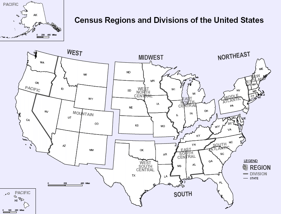
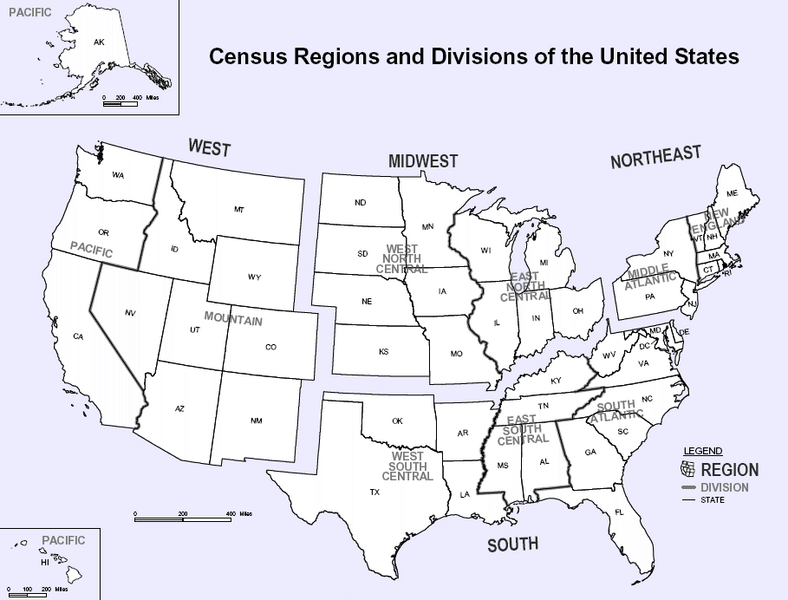
Map of U.S. Census Regions and Divisions. This map shows the four official US Census Regions, and the nine official Divisions within those Regions. See also: Image:US Census regional map.gif.
Licenza[modifica]
Quest'opera è nel pubblico dominio negli Stati Uniti d'America poiché è opera del Governo Federale degli Stati Uniti secondo i termini del titolo 17, capitolo 1, sezione 105 del Codice USA. Vedi anche Copyright per maggiori informazioni.
Nota: la norma si applica solo ad opere prodotte dal governo federale e non dai singoli stati, territori, commonwealth, contee, suddivisioni, municipalità o qualsiasi altra suddivisione degli Stati Uniti. Non si applica inoltre ai francobolli pubblicati dallo United States Postal Service fino al 1978 (vedi 206.02(b) of Compendium II: Copyright Office Practices).
|
 | |
| Questo file è stato identificato come libero da restrizioni conosciute riguardanti le leggi sul copyright, compresi tutti i diritti connessi e vicini. | ||

|
File:Census Regions and Division of the United States.svg è una versione vettoriale di questo file. Dovrebbe essere usata quella versione al posto di questo file PNG.
File:Census Regions and Divisions.PNG → File:Census Regions and Division of the United States.svg
Per maggiori informazioni, vedi Help:SVG. |
 |
Cronologia del file
Fare clic su un gruppo data/ora per vedere il file come si presentava nel momento indicato.
| Data/Ora | Miniatura | Dimensioni | Utente | Commento | |
|---|---|---|---|---|---|
| attuale | 11:56, 9 nov 2023 | | 909 × 692 (92 KB) | Harold (discussione | contributi) | Reverted to version as of 19:46, 13 June 2010 (UTC), COM:OW |
| 22:08, 3 set 2020 |  | 2 200 × 1 700 (103 KB) | ACupOfCoffee (discussione | contributi) | Census regions were changed in 2013. | |
| 19:46, 13 giu 2010 |  | 909 × 692 (92 KB) | Ras67 (discussione | contributi) | cropped, wm removed | |
| 22:11, 29 nov 2006 |  | 916 × 699 (107 KB) | Electionworld (discussione | contributi) | {{ew|en|NThurston}} Map of U.S. Census Regions and Divisions. == Licensing == {{PD-USGov}} Category:Maps of the United States |
Impossibile sovrascrivere questo file.
Utilizzo del file
La seguente pagina usa questo file:
Utilizzo globale del file
Anche i seguenti wiki usano questo file:
- Usato nelle seguenti pagine di bn.wikipedia.org:
- Usato nelle seguenti pagine di ca.wikipedia.org:
- Usato nelle seguenti pagine di de.wikipedia.org:
- Usato nelle seguenti pagine di en.wikipedia.org:
- Usato nelle seguenti pagine di eo.wikipedia.org:
- Usato nelle seguenti pagine di gl.wikipedia.org:
- Usato nelle seguenti pagine di it.wikipedia.org:
- Usato nelle seguenti pagine di ja.wikipedia.org:
- Usato nelle seguenti pagine di ko.wikipedia.org:
- Usato nelle seguenti pagine di nn.wikipedia.org:
- Usato nelle seguenti pagine di ro.wikipedia.org:
- Usato nelle seguenti pagine di simple.wikipedia.org:
- Usato nelle seguenti pagine di sk.wikipedia.org:
- Usato nelle seguenti pagine di tr.wikipedia.org:
- Usato nelle seguenti pagine di vec.wikipedia.org:
- Usato nelle seguenti pagine di vi.wikipedia.org: