File:Central europe 1683.png
קפיצה לניווט
קפיצה לחיפוש

גודל התצוגה המקדימה הזאת: 790 × 599 פיקסלים. רזולוציות אחרות: 317 × 240 פיקסלים | 633 × 480 פיקסלים | 1,013 × 768 פיקסלים | 1,280 × 971 פיקסלים.
לקובץ המקורי (1,280 × 971 פיקסלים, גודל הקובץ: 406 ק"ב, סוג MIME: image/png)
כיתובים
כיתובים
נא להוסיף משפט שמסביר מה הקובץ מייצג

|
יש ליצור מחדש את התמונה map הזו באמצעות גרפיקה וקטורית כדוגמת קובץ SVG. לפעולה זו מספר יתרונות, כפי שניתן לקרוא (באנגלית) בדף Commons:Media for cleanup. אם ברשותכם קובץ SVG, אנא העלו אותו. לאחר מכן, החליפו תבנית זו בתבנית
{{vector version available|שם הקובץ.svg}} |
תקציר
[עריכה]
| תיאור |
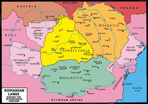
English: Central Europe during the short-term existence of Imre Thököly's Principality of Upper Hungary. - Habsburg and Ottoman territories, including Habsburg Kingdom of Hungary (Royal Hungary) and Habsburg Croatia, Ottoman vassal states (Wallachia, Moldavia, Transylvania, Principality of Upper Hungary (existed between 1682-1685), Montenegro, Ragusa) and Ottoman eyalets. The Ottoman expansion was asked by prince Imre Thököly in Upper Hungary (centered in present-day Slovakia) against the Habsburgs. The Ottoman Rule in Upper Hungary lasted only for 3 years. |
| תאריך יצירה | |
| מקור | נוצר על־ידי מעלה היצירה |
| יוצר | PANONIAN |
| גרסאות אחרות |
Derivative works of this file:
|
רישיון
[עריכה]
אני, בעל זכויות היוצרים על עבודה זו, מפרסם בזאת את העבודה תחת הרישיון הבא:
| קובץ זה זמין לפי תנאי הקדשה עולמית לנחלת הכלל CC0 1.0 של Creative Commons. | |
| האדם ששייך יצירה להיתר הזה הקדיש את היצירה לנחלת הכלל על־ידי ויתור על כל הזכויות שלו או שלה על היצירה בכל העולם לפי חוק זכויות יוצרים, לרבות כל הזכויות הקשורות או הסמוכות כקבוע בחוק. באפשרותך להעתיק, לשנות, להפיץ, או להציג את היצירה, אפילו למטרות מסחריות, וכל זה אפילו מבלי לבקש רשות.
|
References
[עריכה]
- The Times History of Europe, Times Books, London, 2002.
- Peter Rokai - Zoltan Đere - Tibor Pal - Aleksandar Kasaš, Istorija Mađara, Beograd, 2002.
- Dr Dušan J. Popović, Srbi u Vojvodini, knjiga 1, Novi Sad, 1990.
- Dr D. J. Popović, Vojvodina u tursko doba, Zbornik "Vojvodina", knjiga I, Fototipsko izdanje, PROMETEJ, Novi Sad, 2008.
- Halil Inaldžik, Osmansko carstvo, Beograd, 2003.
- Petrit Imami, Srbi i Albanci kroz vekove, Beograd, 2000.
- File:Magyar- és Erdélyország 1629-ben (Pallas).jpg
- http://www.sulinet.hu/oroksegtar/data/telepulesek_ertekei/Erd/pages/images/221.jpg
- http://www.zum.de/whkmla/region/balkans/xsilistra.html
- http://www.euratlas.net/history/europe/1600/index.html
- http://www.freeweb.hu/csodaszarvas/galeria/galeria09/001/large_terkep12.jpg
- http://mek.niif.hu/01800/01885/html/cd5m/kepek/tortenelem/to212pe94185.jpg
- http://www.tortenelemklub.hu/galeries/6/Wesselényi%20legújabb.JPG[dead link]
- http://farm4.static.flickr.com/3361/3657063110_1532418eb3.jpg
- http://www.camo.ch/Images/bpasaluk06.jpg archive copy at the Wayback Machine
- http://medlem.spray.se/zelenika/sandzak.jpg[dead link]
- http://img375.imageshack.us/img375/7287/pasaluk2.png
- http://www.camo.ch/Images3/bhpasaluk.jpg archive copy at the Wayback Machine
- http://xxlworld.xx.ohost.de/povijest/slike/mape/1606.jpg
- http://www.hic.hr/books/pavlicev/images/s05.gif archive copy at the Wayback Machine
- http://api.wb21.net/images/a-torok-hodoltsag-kora-magyar-tortenelem/dr-blaskovics-jozsef,az-ujvari-ejalet-torok-adoosszeirasai.jpg archive copy at the Wayback Machine
.jpg)
היסטוריית הקובץ
ניתן ללחוץ על תאריך/שעה כדי לראות את הקובץ כפי שנראה באותו זמן.
| תאריך/שעה | תמונה ממוזערת | ממדים | משתמש | הערה | |
|---|---|---|---|---|---|
| נוכחית | 12:48, 31 בינואר 2020 | | 971 × 1,280 (406 ק"ב) | Claude Zygiel (שיחה | תרומות) | Belergad eyalet cited in: Artin Hindoğlu's "Kurzwörterbuch Türkisch-Deutsch / Dictionnaire abrégé Turc-Français", Wien 1838, p. 125. |
| 21:35, 8 באפריל 2018 |  | 971 × 1,280 (390 ק"ב) | Filederchest (שיחה | תרומות) | info | |
| 19:06, 8 באפריל 2018 |  | 971 × 1,280 (378 ק"ב) | Filederchest (שיחה | תרומות) | Principality of Upper Hungary | |
| 15:19, 28 בינואר 2017 |  | 1,170 × 1,543 (146 ק"ב) | PANONIAN (שיחה | תרומות) | Reverted to version as of 20:47, 8 September 2011 (UTC) - this shows vassal principalities as separate states which they were not | |
| 20:52, 25 בינואר 2017 |  | 1,170 × 1,543 (135 ק"ב) | Mélomène (שיחה | תרומות) | Contrast | |
| 20:47, 8 בספטמבר 2011 |  | 1,170 × 1,543 (146 ק"ב) | PANONIAN (שיחה | תרומות) | corrected version | |
| 16:59, 5 בספטמבר 2011 |  | 1,170 × 1,543 (143 ק"ב) | PANONIAN (שיחה | תרומות) | {{Information |Description ={{en|1=Central Europe in 1683.}} |Source ={{own}} |Author =PANONIAN |Date =2011 |Permission = |other_versions = }} |
אין באפשרותך לדרוס את הקובץ הזה.
שימוש בקובץ
הדפים הבאים משתמשים בקובץ הזה:
- Atlas of Bosnia and Herzegovina
- Atlas of Croatia
- Atlas of Hungary
- Atlas of Moldova
- Atlas of Romania
- Atlas of Slovakia
- Atlas of Transylvania
- Atlas of Vojvodina
- User:J budissin/Uploads/BiH/2017 January 21-31
- User:J budissin/Uploads/BiH/2018 April 1-10
- User:J budissin/Uploads/BiH/2020 January 21-31
- Commons:Graphic Lab/Map workshop/Archive/2014
- Category:Budin Province, Ottoman Empire
שימוש גלובלי בקובץ
אתרי הוויקי השונים הבאים משתמשים בקובץ זה:
- שימוש באתר an.wikipedia.org
- שימוש באתר ar.wikipedia.org
- שימוש באתר arz.wikipedia.org
- שימוש באתר azb.wikipedia.org
- שימוש באתר az.wikipedia.org
- שימוש באתר ba.wikipedia.org
- שימוש באתר be-tarask.wikipedia.org
- שימוש באתר be.wikipedia.org
- שימוש באתר bg.wikipedia.org
- שימוש באתר bn.wikipedia.org
- שימוש באתר bs.wikipedia.org
- שימוש באתר ca.wikipedia.org
- שימוש באתר cs.wikipedia.org
- שימוש באתר de.wikipedia.org
- שימוש באתר el.wikipedia.org
- שימוש באתר en.wikipedia.org
צפייה בשימושים גלובליים נוספים של קובץ זה.
מטא־נתונים
קטגוריות:
- Maps of the history of Central Europe
- 1683 in Europe
- 1683 in Romania
- 1683
- Budin Province, Ottoman Empire
- Eyalet of Bosnia
- Eğri Province, Ottoman Empire
- Kanije Province, Ottoman Empire
- Kingdom of Hungary (1526–1867)
- Maps of Temeşvar Province, Ottoman Empire
- Maps of Wallachia
- Maps of eyalets of the Ottoman Empire
- Maps of the Habsburg Monarchy
- Maps of the Ottoman period in the history of Serbia
- Maps of the Principality of Moldavia
- Maps of the history of Banat
- Maps of the history of Bosnia and Herzegovina under Ottoman Empire
- Maps of the history of Croatia (1526–1918)
- Maps of the history of Early Modern Romania
- Maps of the history of Hungary (1526–1700)
- Maps of the history of Moldova
- Maps of the history of Slovakia
- Maps of the history of Transylvania
- Maps of the history of Vojvodina
- Maps of the history of the Ottoman Empire in the 1680s
- Maps of vassal states of the Ottoman Empire
- Principality of Transylvania
- Principality of Upper Hungary
- Romania in the 17th century
- Uyvar Province, Ottoman Empire
- Varat Province, Ottoman Empire