File:Chancellorsville May4-6.png
Jump to navigation
Jump to search
Size of this preview: 800 × 533 pixels. Other resolutions: 320 × 213 pixels | 640 × 427 pixels | 1,024 × 683 pixels | 1,280 × 854 pixels | 2,560 × 1,707 pixels | 6,300 × 4,201 pixels.
Original file (6,300 × 4,201 pixels, file size: 8.55 MB, MIME type: image/png)
Captions
Captions
Add a one-line explanation of what this file represents
| Description |
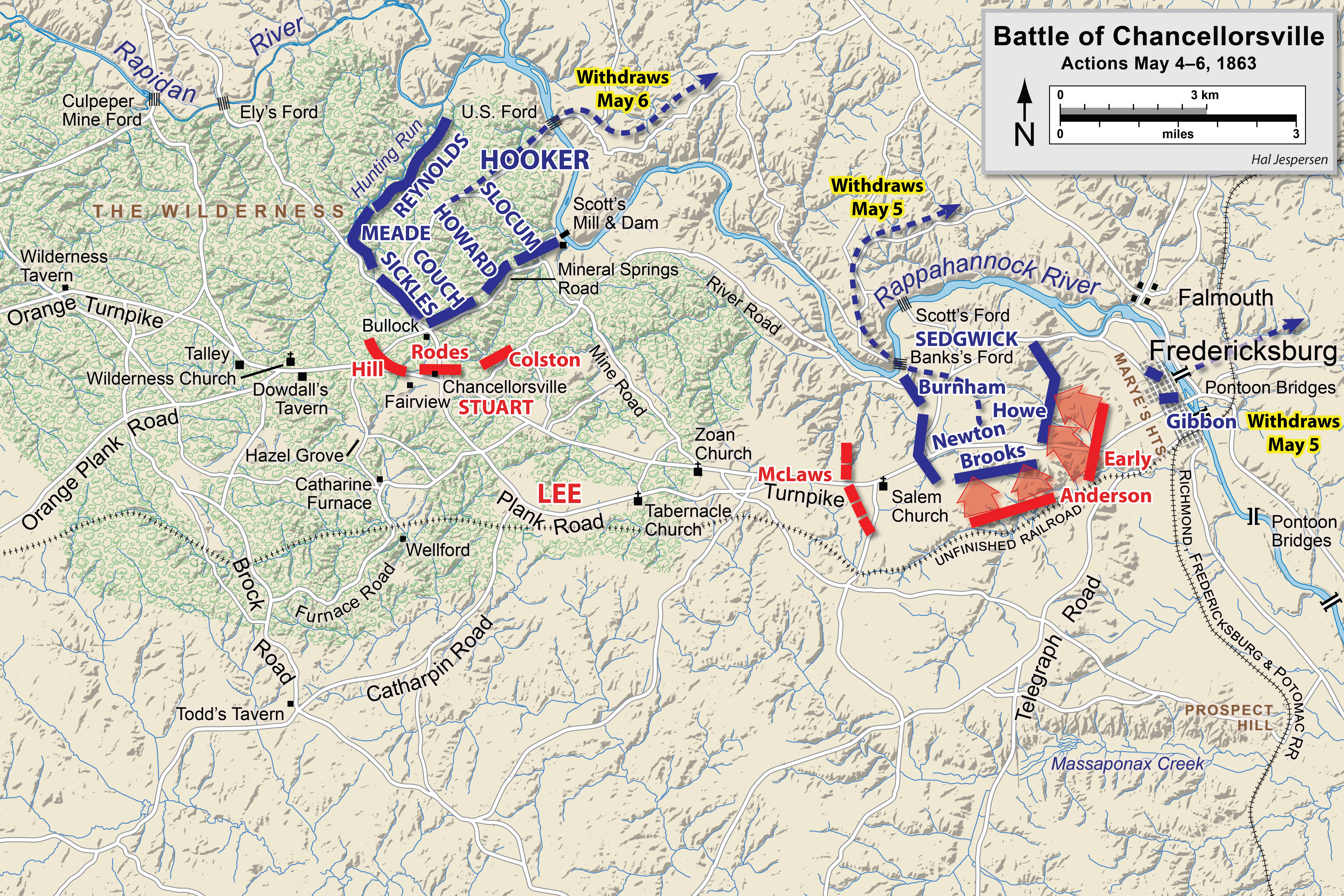
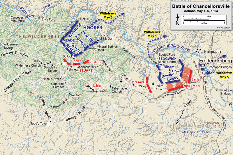
English: Map of a portion (May 4-6) of the battle of Chancellorsville of the American Civil War. This map replaces the map entitled Chancellorsville May4.png.
Drawn in Adobe Illustrator CS6 by Hal Jespersen. Graphic source file is available at http://www.cwmaps.com This file is licensed under the Creative Commons Attribution 3.0 Unported license. Attribution: Map by Hal Jespersen, www.cwmaps.com
|
| Date | |
| Source | Own work |
| Author | Hlj |
File history
Click on a date/time to view the file as it appeared at that time.
| Date/Time | Thumbnail | Dimensions | User | Comment | |
|---|---|---|---|---|---|
| current | 18:15, 14 March 2023 | | 6,300 × 4,201 (8.55 MB) | Hlj (talk | contribs) | improved graphics |
| 17:52, 30 December 2012 |  | 2,500 × 1,822 (1.37 MB) | Hlj (talk | contribs) | Corrected spelling error, made minor graphic improvements | |
| 22:17, 3 June 2011 |  | 2,500 × 1,822 (1.31 MB) | Hlj (talk | contribs) | Improved the accuracy of the terrain and some landmarks. Same license. | |
| 19:33, 27 March 2011 |  | 2,500 × 1,822 (1.28 MB) | Hlj (talk | contribs) | Update to graphical style of rivers and roads. Same license. | |
| 22:01, 27 January 2011 |  | 2,500 × 1,822 (1,005 KB) | Hlj (talk | contribs) | Minor updates to feature labeling and unit positions and actions. {{cc-by-3.0|Map by Hal Jespersen, www.posix.com/CW}} | |
| 00:17, 28 November 2010 |  | 2,500 × 1,822 (999 KB) | Hlj (talk | contribs) | {{Information |Description={{en|1=Map of a portion (May 4-6) of the battle of Chancellorsville of the American Civil War. This map replaces the map entitled Chancellorsville May4.png. Drawn in Adobe Illustrator CS5 by Hal Jespersen. Graphic source fil |
You cannot overwrite this file.
File usage on Commons
The following page uses this file:
File usage on other wikis
The following other wikis use this file:
- Usage on en.wikipedia.org
- Usage on es.wikipedia.org
- Usage on fr.wikipedia.org
- Usage on hu.wikipedia.org
- Usage on ms.wikipedia.org
- Usage on pt.wikipedia.org
- Usage on ro.wikipedia.org