File:Chernyakhov.PNG
Pereiti į navigaciją
Jump to search
Geresnė raiška negalima.
Chernyakhov.PNG (777 × 471 taškų, rinkmenos dydis: 10 KiB, MIME tipas: image/png)
Captions
Captions
Add a one-line explanation of what this file represents
Aprašymas[keisti]

|
Please translate the English parts of this template into Lithuanian.
Yra šio failo vektorinė versija (SVG formatu). Dėl geresnės kokybės ji turėtų būti naudojama vietoj šio rastrinio paveikslėlio. File:Chernyakhov.PNG → File:Chernyakhov.svg
Daugiau informacijos apie vektorinę grafiką rasite straipsnyje Commons perėjimas prie SVG. Taip pat yra informacijos apie MediaWiki SVG formato palaikymą. |
 |
| Aprašymas |
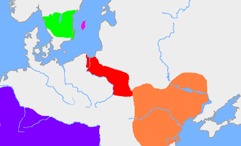
English: The green area is the traditional extent of Götaland and the pink area is the island of Gotland. The red area is the extent of the Wielbark culture in the early 3rd century, and the orange area is the Chernyakhov culture, in the early 4th century. The purple area is the Roman Empire.
The extent of the Wielbark culture is based on Zbigniew Babik: "Najstarsza warstwa nazewnicza na ziemiach polskich" Cracow 2001. The extent of the Chernyakhov culture is based on R. Wołągiewicz (1993), a map drawn by Lars Östlin, in Kaliff's Gothic Connections. Contacts between eastern Scandinavia and the southern Baltic coast 1000 BC – 500 AD (2001:29)Deutsch: Ungefähre Ausbildung der Chernjachov-Kultur im 3. Jahrhundert (orange) und der Wielbark-Kultur (rot). |
| Šaltinis | Wiglaf's map, based on Dbachmann's blank map. |
| Autorius | en:User:Wiglaf, en:User:Dbachmann |
Licencija[keisti]

|
Suteikiamas leidimas kopijuoti, platinti ir/ar redaguoti šį dokumentą pagal GNU Free Documentation licencijos versijos 1.2 ar bet kurios vėlesnės versijos sąlygas, publikuotas Free Software Foundation; be nekintamų dalių, be priekinių ir galinių tekstinių žymų viršeliuose. Šios licencijos kopija įtraukta dalyje, pavadintoje GNU Free Documentation License. |
| Šiam failui taikoma Creative Commons Attribution-Share Alike 3.0 Unported licencija. | ||
| ||
| Licencijos šablonas buvo priskirtas šiam failui kaip GFDL licencijos atnaujinimo dalis. |
Image history[keisti]
| date/time | username | edit summary |
|---|---|---|
| 22:03, 19 August 2005 | en:User:Wiglaf | |
| 20:55, 26 July 2005 | en:User:Wiglaf | |
| 13:04, 26 July 2005 | en:User:Wiglaf | |
| 12:57, 26 July 2005 | en:User:Wiglaf |
Rinkmenos istorija
Paspauskite ant datos/laiko, kad pamatytumėte rinkmeną tokią, kokia ji buvo tuo metu.
| Data/Laikas | Miniatiūra | Matmenys | Naudotojas | Paaiškinimas | |
|---|---|---|---|---|---|
| dabartinis | 03:34, 9 sausio 2022 | | 777 × 471 (10 KiB) | Jul059 (aptarimas | indėlis) | Lossless file size reduction |
| 16:57, 4 kovo 2006 |  | 777 × 471 (25 KiB) | Maksim (aptarimas | indėlis) | La bildo estas kopiita de wikipedia:en. La originala priskribo estas: my own map, based on User:Dbachmann's blank map. The extent of the Wielbark culture is based on Zbigniew Babik: "Najstarsza warstwa nazewnicza na ziemiach polskich" Cracow 200 |
Jūs negalite perrašyti šios rinkmenos.
Rinkmenos naudojimas
Šie puslapiai naudoja šią rinkmeną:
Visuotinis rinkmenos naudojimas
Ši rinkmena naudojama šiose viki svetainėse:
- Naudojama af.wikipedia.org
- Naudojama an.wikipedia.org
- Naudojama ar.wikipedia.org
- Naudojama arz.wikipedia.org
- Naudojama ba.wikipedia.org
- Naudojama be-tarask.wikipedia.org
- Naudojama be.wikipedia.org
- Naudojama bg.wikipedia.org
- Naudojama bs.wikipedia.org
- Naudojama ca.wikipedia.org
- Naudojama cv.wikipedia.org
- Naudojama da.wikipedia.org
- Naudojama de.wikipedia.org
- Naudojama de.wikibooks.org
- Naudojama el.wikipedia.org
- Naudojama en.wikipedia.org
Žiūrėti visuotinį šios rinkmenos naudojimą.